Route 35 is a state highway in the U.S. state of New Jersey, primarily traveling through the easternmost parts of Middlesex, Monmouth, and Ocean counties. It runs 58.1 mi (93.5 km) from the entrance to Island Beach State Park in Berkeley Township, Ocean County, to an intersection with Lincoln Highway/St. Georges Avenue (Route 27) in Rahway, Union County. Between Seaside Park and Mantoloking, Route 35 follows the right-of-way of the former Pennsylvania Railroad along the Jersey Shore. The route heads through Point Pleasant Beach and crosses the Manasquan River on the Brielle Bridge, meeting the intersection of Route 34 and Route 70 at the former Brielle Circle in Wall Township. From there, Route 35 heads north and interchanges with Route 138, an extension of I-195, continuing north through Monmouth County before crossing the Victory Bridge over the Raritan River into Perth Amboy, where the route continues north to Rahway.

Route 70 is a state highway located in the U.S. state of New Jersey. It extends 59.8 mi (96.24 km) from an interchange with Route 38 in Pennsauken, Camden County, east to an intersection with Route 34 and Route 35 in Wall Township, Monmouth County. Route 70 cuts across the middle of the state as a two-lane highway through the Pine Barrens in Burlington and Ocean counties. A popular truck route, it provides access between Philadelphia and the surrounding Philadelphia metro area and the Jersey Shore resorts, particularly Long Beach Island by way of Route 72. It is also a congested commercial route within Philadelphia's New Jersey suburbs. The western section in Cherry Hill and Marlton is a four- to eight-lane divided highway that serves as a major suburban arterial and is locally known as Marlton Pike. The eastern section in Monmouth and Ocean counties is also a multilane divided highway that runs through suburban areas.

Brielle is a borough located in southern Monmouth County, in the U.S. state of New Jersey, along the Manasquan River. As of the 2020 United States census, the borough's population was 4,982, its highest decennial count ever and an increase of 208 (+4.4%) from the 2010 census count of 4,774, which in turn reflected a decline of 119 (−2.4%) from the 4,893 counted in the 2000 census.

Manasquan is a borough in Monmouth County, in the U.S. state of New Jersey, on the Jersey Shore. As of the 2020 United States census, the borough's population was 5,938, an increase of 41 (+0.7%) from the 2010 census count of 5,897, which in turn reflected a decline of 413 (−6.5%) from the 6,310 counted in the 2000 census.

Point Pleasant Beach is a coastal borough situated on the Jersey Shore, and the northernmost community directly facing the Atlantic Ocean within Ocean County, in the U.S. state of New Jersey. It lies at the northern end of the Barnegat Peninsula, which serves as a barrier island separating Barnegat Bay from the open Atlantic Ocean. The borough's name is derived from its location.

Route 71 is a state highway in New Jersey that runs 16.7 miles (26.9 km) near the shore in Monmouth County. It begins at Route 35 in Brielle just north of the Manasquan River and the Ocean County line and heads north to Route 35 in Eatontown with a four block concurrency with Route 35 in Belmar. Monmouth University is located off Route 71 in West Long Branch.

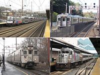
NJ Transit Rail Operations is the rail division of NJ Transit. It operates commuter rail service in New Jersey, with most service centered on transportation to and from New York City, Hoboken, and Newark. NJ Transit also operates rail service in Orange and Rockland counties in New York under contract to Metro-North Railroad. The commuter rail lines saw 57,179,000 riders in 2023, making it the third-busiest commuter railroad in North America and the longest commuter rail system in North America by route length.

The Metedeconk River is a tributary of Barnegat Bay in Ocean County, New Jersey in the United States.
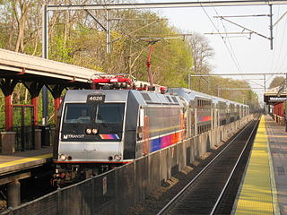
The North Jersey Coast Line is a commuter rail line running from Rahway to Bay Head, New Jersey, traversing through the Jersey Shore region. Operated by New Jersey Transit, the line is electrified as far south as Long Branch. On rail system maps it is colored light blue, and its symbol is a sailboat. The line runs along the former New York & Long Branch Railroad, which was co-owned by the Central Railroad of New Jersey and the Pennsylvania Railroad.

The Manasquan River is a 26.5-mile-long (42.6 km) waterway in central New Jersey.
New Jersey's 4th congressional district is a congressional district that stretches along the New Jersey Shore. It has been represented by Republican Chris Smith since 1981, the second-longest currently serving member of the US House of Representatives and the longest serving member of Congress from New Jersey in history.

Point Pleasant Beach is a train station located in Point Pleasant Beach, in Ocean County, New Jersey, United States, on NJ Transit's North Jersey Coast Line, and is one of the most significant stops on the NJCL portion between Long Branch and Bay Head. This station is located on one of the borough's major arteries, Arnold Avenue, Route 35, several blocks from the Atlantic Ocean, boardwalk, Manasquan Inlet marina, and within the community's downtown business, shopping, dining and entertainment nexus. The station is handicapped-accessible.
The Barnegat Peninsula, also known as the Island Beach Peninsula or Barnegat Bay Island and colloquially as "the barrier island", is a 20-mile (32 km) long, narrow barrier peninsula located on the Jersey Shore in Ocean County, New Jersey, United States, that divides the Barnegat Bay from the Atlantic Ocean. It is a vacation destination and summer colony area and is heavily dependent on tourism, real estate and fishing.

The Glimmer Glass Bridge is a county owned bridge in Monmouth County, New Jersey, United States. It carries traffic from Brielle Road over the Glimmer Glass, a navigable tidal inlet of the Manasquan River, between Manasquan and Brielle. It has also been on the National Register of Historic Places, since 2008. Due to its age, Commercial vehicles cannot be driven over it. It also allows Bicycles and pedestrians to walk on the wooden sidewalk.

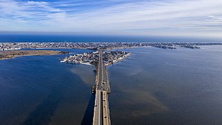
The Manasquan Inlet is an inlet that connects the Atlantic Ocean with the Manasquan River, dividing the counties of Ocean County and Monmouth County in the state of New Jersey. Passage to Bay Head Harbor and the Barnegat Bay is possible via the Point Pleasant Canal.

WR Draw is an out-of-service railroad bridge crossing the Passaic River between Newark and the Arlington section of Kearny, New Jersey. The plate girder rim-bearing swing bridge, originally built in 1897 and modified in 1911 and 1950, is the 14th bridge from the river's mouth at Newark Bay and is 8.1 miles (13.0 km) upstream from it. Last used for regular passenger service in 2002, it is welded in closed position as its height is not considered a hazard to navigation.
Morgan Draw is railroad moveable bridge over the Cheesequake Creek between the Morgan section of Sayreville and Laurence Harbor in Old Bridge in Middlesex County, New Jersey, United States. Located at MP 0.2 near the mouth on the Raritan Bay, the bascule bridge lies just upstream of the New Jersey Route 35 crossing. It is owned and operated by New Jersey Transit Rail Operations (NJT) and substantially rehabilitated in 2005-2008. A storm surge during Hurricane Sandy in 2012 caused severe damage to the bridge.

The Shark River Draw, commonly known as the Belmar Bridge, is a moveable drawbridge that over the Shark River Inlet, an inlet at the mouth of the Shark River in the towns of Belmar and Avon-by-the-Sea Monmouth County, New Jersey, United States, just west of the Atlantic Ocean.
Beach Bridge, or Beach Drawbridge, is a railroad swing bridge over Beach Thorofare Waterway in Atlantic City, Atlantic County, New Jersey, United States just west of the Atlantic City Rail Terminal. It carries the New Jersey Transit Rail Operations (NJT) Atlantic City Line at milepoint mile 68.9 and is parallel to the Atlantic City Expressway. Built in 1922, the swing bridge was rehabilitated in 1988 and 2004. Operation of bridge openings for maritime traffic is provided by the Title 33 of the Code of Federal Regulations.
Oceanport Draw is railroad moveable bridge over the Oceanport Creek, a tributary of the Shrewsbury River, in Oceanport in Monmouth County, New Jersey, United States. It is owned and operated by New Jersey Transit Rail Operations (NJT).