Brooklyn (Jacksonville)

Last updated
Brooklyn
FidelityNational2Jacksonville-Jul2009.JPG
Fidelity National Financial located on Riverside Avenue in Brooklyn.
Jacksonville Urban Core.png
Red pog.svg
Brooklyn
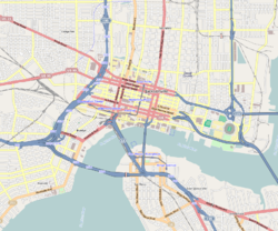
Location within Central Jacksonville
Coordinates: 30°19′19″N81°40′34″W / 30.321919°N 81.676162°W / 30.321919; -81.676162
Government
   City Council Garrett L. Dennis
   State Assembly Tracie Davis (D)
   State Senate Audrey Gibson (D)
   U.S. House Aaron Bean (R)
Area
[1]
  Total1.30 km2 (0.502 sq mi)
  Land1.30 km2 (0.502 sq mi)
Population
 (2008)
  Total325
  Density250/km2 (650/sq mi)
  [1]
ZIP Code
32202, 32204
Area code 904

Brooklyn is a neighborhood of Jacksonville, Florida, considered part of the downtown area. Originally a residential suburb, commercial uses became prominent during the 20th century, particularly along the St. Johns River and Riverside Avenue, and the area became included in Jacksonville's central business district. In the 21st century, it has become the site of mixed-use developments.

Contents

Location

Rapid redevelopment in Brooklyn has transformed once blighted areas of the neighborhood. Brooklynjax.jpg
Rapid redevelopment in Brooklyn has transformed once blighted areas of the neighborhood.

Brooklyn is located along the St. Johns River, south of Lavilla and the Downtown Core, and immediately north of Riverside. It is roughly bounded by McCoy's Creek and the CSX Railroad lines to the north, the river to the east, and Interstate 95 to the south and west. Brooklyn has come to be considered part of Jacksonville's greater downtown. [2]

History

The area was first settled in 1801, when Phillip Dell started a large 800-acre plantation there known as Dell's Bluff. Dell's Bluff changed hands several times before the American Civil War. After the war it was acquired by Miles Price, who sold the southern half of the property to be developed as the suburb of Riverside. The northern section he retained and developed himself as Brooklyn. [3]

It appears that Price gave Brooklyn its name, but it is not known why a former staunch Confederate would have chosen a name so associated with the New York borough of Brooklyn. Price's Brooklyn was initially a residential suburb, growing quickly with the establishment of a streetcar line. The area held a population of 1,000 and a few hundred homes and mansions. African-American former soldiers (known as Buffalo Soldiers) lived in the neighborhood, and one of their houses still stands, though in disrepair. [4] In 1887 Brooklyn and several other suburbs were annexed by Jacksonville. It remained primarily residential into the 20th century, but it eventually developed into a commercial and industrial area with the increasing use of the railway. In the 1950s, Interstate 95 over the Fuller Warren Bridge cut off the historically black neighborhood. [5] In the late 20th century, a number of commercial skyscrapers and other building were constructed along the river and Riverside Avenue. [3]

Subsequently, a rift emerged between the office-centered part of the neighborhood on the river and the traditional neighborhood further inland. As such, the city developed plans in the late 20th and early 21st century to reintroduce residential zoning and mixed-use development. [3] [6]

Gentrification is affecting the long-term residents of Brooklyn. [5] [7]

Notes

  1. 1 2 Brooklyn neighborhood in Jacksonville, Florida (FL), 32202, 32204 subdivision profile - real estate, apartments, condos, homes, community, population, jobs, income, ...
  2. "Celebrating the River: A Plan for Downtown Jacksonville". www.coj.net. City of Jacksonville. 2000. pp. 20–21. Archived from the original (PDF) on August 8, 2013. Retrieved February 21, 2013.
  3. 1 2 3 Wood, pp. 105–107.
  4. Gilmore, Tim (2016-12-25). "Brooklyn: Buffalo Soldier's House". Jax Psycho Geo. Retrieved 2017-02-02.
  5. 1 2 Pantazi, Andrew (2014-12-04). "Long-time residents in Jacksonville's Brooklyn neighborhood look to hang on amid major changes". Florida Times-Union. Jacksonville, FL. Retrieved 2017-02-02.
  6. "History of Downtown: Brooklyn". Downtown Vision inc. 2013. Retrieved February 27, 2013.
  7. Gilmore, Tim (2017-01-25). "Gentrification: A perspective from a long time resident". Modern Cities. Retrieved 2017-02-02.

Related Research Articles

<span class="mw-page-title-main">Jacksonville, Florida</span> Largest city in Florida, United States

Jacksonville is a city located on the Atlantic coast of northeastern Florida, the most populous city proper in the state and the largest city by area in the contiguous United States as of 2020. It is the seat of Duval County, with which the city government consolidated in 1968. Consolidation greatly increased its population relative to its extended size which placed most of its metropolitan population within the city limits. As of July 2022, Jacksonville's population is 971,319, making it the most populous city in the Southeastern United States and the largest in the South outside the state of Texas. With a population of 1,733,937, the Jacksonville metropolitan area ranks as Florida's fourth-largest metropolitan region.

<span class="mw-page-title-main">Gay village</span> Geographical area within a city that is inhabited or frequented by LGBT people

A gay village, also known as a gayborhood, is a geographical area with generally recognized boundaries that is inhabited or frequented by many lesbian, gay, bisexual, transgender, and queer (LGBT) people. Gay villages often contain a number of gay-oriented establishments, such as gay bars and pubs, nightclubs, bathhouses, restaurants, boutiques, and bookstores.

<span class="mw-page-title-main">North Loop, Minneapolis</span> Neighborhood in Hennepin, Minnesota, United States

The North Loop is a neighborhood in the Central community of Minneapolis.

A streetcar suburb is a residential community whose growth and development was strongly shaped by the use of streetcar lines as a primary means of transportation. Such suburbs developed in the United States in the years before the automobile, when the introduction of the electric trolley or streetcar allowed the nation’s burgeoning middle class to move beyond the central city’s borders. Early suburbs were served by horsecars, but by the late 19th century cable cars and electric streetcars, or trams, were used, allowing residences to be built farther away from the urban core of a city. Streetcar suburbs, usually called additions or extensions at the time, were the forerunner of today's suburbs in the United States and Canada. San Francisco's Western Addition is one of the best examples of streetcar suburbs before westward and southward expansion occurred.

The Greater Richmond, Virginia area has many neighborhoods and districts.

Tampa Heights is one of the oldest neighborhoods within the city limits of Tampa, situated in the central part of the city. As of the 2000 census, the neighborhood had a population of 16,393.

<span class="mw-page-title-main">Elliot Park, Minneapolis</span> Neighborhood in Hennepin, Minnesota, United States

Elliot Park is a neighborhood within the larger Central community in Minneapolis. It was the home of some of Minneapolis's wealthiest citizens in Minneapolis's early years. As the city grew and encompassed the neighborhood, most of the wealthy citizens left to build in more secluded neighborhoods like Lowry Hill and Kenwood. A few historic mansions and buildings from Minneapolis's early years can be found in some parts of Elliot Park.

<span class="mw-page-title-main">Jacksonville metropolitan area, Florida</span> Metropolitan statistical area in the United States

The Jacksonville Metropolitan Area, also called the First Coast, Metro Jacksonville, or Northeast Florida, is the metropolitan area centered on the principal city of Jacksonville, Florida and including the First Coast of North Florida. As of the 2020 United States census, the total population was 1,605,848. The Jacksonville–St. Marys–Palatka, FL–GA Combined Statistical Area (CSA) had a population of 1,733,937 in 2020 and was the 34th largest CSA in the United States. The Jacksonville metropolitan area is the 40th largest in the country and the fourth largest in the State of Florida, behind the Miami, Tampa, and Orlando metropolitan areas.

<span class="mw-page-title-main">Downtown Jacksonville</span> Neighborhood of Jacksonville, Florida

Downtown Jacksonville is the historic core and central business district (CBD) of Jacksonville, Florida. It comprises the earliest area of the city to be developed and is located in its geographic center along the narrowing point of the St. Johns River.

<span class="mw-page-title-main">Neighborhoods of Jacksonville</span>

There are more than 500 neighborhoods within the area of Jacksonville, Florida, the largest city in the contiguous United States by area. These include Downtown Jacksonville and surrounding neighborhoods. Additionally, greater Jacksonville is traditionally divided into several major sections with amorphous boundaries: Northside, Westside, Southside, and Arlington, as well as the Jacksonville Beaches.

<span class="mw-page-title-main">Neighborhoods in Spokane, Washington</span>

Neighborhoods in Spokane, Washington are officially grouped by the Spokane City Council into three main city council districts: 1, 2, and 3. Each city council district contains multiple, official neighborhoods that are recognized with a neighborhood council. Informally, neighborhoods are colloquially grouped by local geographical, geological, cultural, or historical features The list of neighborhoods below is organized based on the official designations by the City of Spokane. Unofficial neighborhoods and districts are listed within the official neighborhood in which they are located.

The following is a list of neighborhoods and commercial districts in Sioux City, Iowa.

<span class="mw-page-title-main">Neighborhoods in Saint Paul, Minnesota</span>

Saint Paul, Minnesota, consists of 17 officially defined city districts or neighborhoods.

<span class="mw-page-title-main">LaVilla</span> Neighborhood of Jacksonville

LaVilla is a historic African American neighborhood of Jacksonville, Florida and a was formerly an independent city. It developed after the American Civil War and was eventually annexed to the city of Jacksonville in 1887 and is now considered part of downtown.

<span class="mw-page-title-main">Transportation in Jacksonville, Florida</span> Overview of transportation in Jacksonville, Florida

The Jacksonville transportation network includes ground, air, and sea options for passenger and freight transit. The Jacksonville Port Authority (Jaxport) operates the Port of Jacksonville, which includes container shipping facilities at Blount Island Marine Terminal, the Talleyrand Marine Terminal and the Dames Point Marine Terminal. Jacksonville Aviation Authority managers Jacksonville International Airport in Northside, as well as several smaller airports. The Jacksonville Transportation Authority (JTA) operates bus, people mover, and park-n-ride services throughout the city and region. A major bus terminal at the intermodal Rosa Parks Transit Station serves as JTA's main transit hub. Various intercity bus companies terminate near Central Station. Amtrak operates passenger rail service to and from major cities throughout North America. The city is bisected by major highways, I-95 and I-10, I-295 creates a full beltway around the city.

<span class="mw-page-title-main">Neighborhoods in Springfield, Massachusetts</span>

The City of Springfield, Massachusetts, has 19 distinct neighborhoods. Many feature subdivisions known by other names, such as The X, Hungry Hill, and Mason Square. Springfield's neighborhoods fan out north, south, and east, from its original, colonial settlement in what is now Metro Center.

South River City is a community located in Austin, Texas. Also frequently called Travis Heights, the neighborhood is located south of the city's urban core, just below Lake Lady Bird in South Austin. The area encompasses a portion of ZIP code 78704.

<span class="mw-page-title-main">Riverside and Avondale</span> Neighborhood of Jacksonville, Florida

Riverside and Avondale are two adjacent and closely associated neighborhoods, alternatively considered one continuous neighborhood, of Jacksonville, Florida. The area is primarily residential, but includes some commercial districts, including Five Points, the King Street District, and the Shoppes of Avondale.

<span class="mw-page-title-main">Riverside Park (Jacksonville)</span>

Riverside Park is an 11.4-acre (46,000 m2) public park, located in the heart of Riverside, one of the most historic neighborhoods near downtown Jacksonville, Florida. It is the second oldest park in the city.

<span class="mw-page-title-main">San Marco (Jacksonville)</span> Neighborhood of Jacksonville, Florida

San Marco is a neighborhood of Jacksonville, Florida, south of Downtown across the St. Johns River. The neighborhood was formerly the independent city of South Jacksonville until it was annexed by Jacksonville in 1932. The neighborhood is primarily residential, with an integrated commercial sector known as San Marco Square.

References