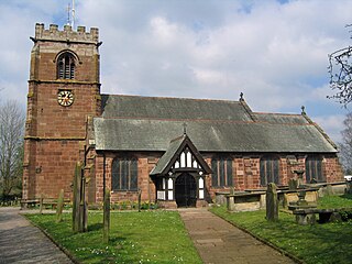
Tattenhall is a village and former civil parish, now in the parish of Tattenhall and District, 8 miles (13 km) south-east of Chester, in the unitary authority area of Cheshire West and Chester and the ceremonial county of Cheshire, England. In the 2001 census, the population was recorded as 1,986, increasing to 2,079 by the 2011 census.

Oban railway station is a railway station serving Oban in Scotland. It is the terminus of one branch of the highly scenic West Highland Line, sited 71 miles 44 chains (115.1 km) from Callander, via Glen Ogle. It was originally the terminus of the Callander and Oban Railway. All services are operated by ScotRail, who also manage the station.

Achanalt railway station is a geographically remote railway station on the Kyle of Lochalsh Line, serving the village of Achanalt in the north of Scotland. The station is 21 miles 34 chains (34.5 km) from Dingwall, between Lochluichart and Achnasheen. ScotRail, who manage the station, operate all services.

Bache is a small civil parish and suburb of Chester, in the unitary authority of Cheshire West and Chester and the ceremonial county of Cheshire, England. Located to the north of the city, Bache combines with Moston and Upton-by-Chester to form a joint parish council.
Broxton is a village and civil parish in the unitary authority of Cheshire West and Chester and the ceremonial county of Cheshire, England. The village is 11 miles south of Chester, and only 10 miles east of Wrexham in Wales. The civil parish also contains the small settlements of Barnhill, Bolesworth, Brown Knowl, Fuller's Moor and Meadow Bank. According to the 2001 Census it had a total population of 390, increasing to 461 at the 2011 census.
Chartered in 1903, the Ocilla and Valdosta Railroad had originally planned on building a railroad from Macon, GA to Valdosta, GA. In 1905 it acquired track between Broxton, GA and Hazlehurst, GA from the Broxton, Hazlehurst and Savannah Railroad. By 1906 it was operating between Broxton and Ocilla, GA and was constructing track to Fitzgerald, GA. The O&V then ran into financial trouble and sold the Broxton to Hazlehurst section to the Douglas, Augusta and Gulf Railway in 1907 and the next year the remainder of the O&V was sold to the Fitzgerald, Ocilla and Broxton Railroad.

Bellshill railway station is a railway station in the town of Bellshill, North Lanarkshire, Scotland. The station is managed by ScotRail and served by Argyle Line and Shotts Line services. The station is adjacent to Bellshill Main Street, on Hamilton Road, and was opened by the Caledonian Railway as part of the Cleland and Midcalder Line on 1 May 1879. West of the station, the Glasgow, Bothwell, Hamilton and Coatbridge Railway crossed with a second station in the town to the north west - this ceased to carry passengers back in 1951.

Achnasheen railway station is a remote railway station on the Kyle of Lochalsh Line, serving the village of Achnasheen in the north of Scotland. The station is 27 miles 72 chains (44.9 km) from Dingwall, between Achanalt and Achnashellach. ScotRail, who manage the station, operate all services.

Duirinish railway station is a remote railway station on the Kyle of Lochalsh Line near the settlement of Duirinish in the Highlands, northern Scotland. The station is approximately 2 miles (3 km) inland of Scotland's west coast, near Loch Lundie. The station is 59 miles 58 chains (96.1 km) from Dingwall, between Kyle of Lochalsh and Plockton. ScotRail, who manage the station, operate all services here.

Dalmally railway station is a railway station serving the village of Dalmally, near Loch Awe in Scotland. This station is on the Oban branch of the West Highland Line, originally part of the Callander and Oban Railway. It is sited 46 miles 76 chains (75.6 km) from Callander via Glen Ogle, between Tyndrum Lower and Loch Awe. ScotRail manage the station and operate all services.

Baillieston railway station is located in Caledonia Road on the southern boundary of the Baillieston area of Glasgow, Scotland, with the Broomhouse area on the other side of the tracks. It is on the Whifflet Line, 8 miles (13 km) east of Glasgow Central railway station. Train services are provided by ScotRail.

Scotstounhill railway station serves Scotstounhill in Glasgow, Scotland. The station lies on the Argyle and North Clyde lines, serving the districts of Scotstoun and Knightswood, with trains to and from Glasgow Central or Queen Street stations and on into the east end.

Alexandra Parade railway station is a railway station in Glasgow, Scotland. The station is 1+3⁄4 miles (2.8 km) east of Glasgow Queen Street on the Springburn branch of the North Clyde Line. The station is managed by ScotRail.

Pollokshields West railway station is one of three railway stations in Pollokshields, a district of Glasgow, Scotland. The station is managed by ScotRail and lies on the Cathcart Circle Line. The Cathcart Circle Line has been electrified since 1962 under British Railways.

Dumbreck railway station is a railway station in Dumbreck, a district of Glasgow, Scotland. The station is managed by ScotRail and lies on the Paisley Canal Line, 1¾ miles (3 km) west of Glasgow Central, close to the M77 motorway. It is accessed from the Nithsdale Road at the bridge over the railway. Dumbreck railway station is also the closest station for the Bellahouston Park.

Pollokshaws West railway station is a railway station in Glasgow, Scotland. The station is managed by ScotRail and is served by trains on the Glasgow South Western Line.
Gorbals railway station was a railway station serving the Gorbals area of Glasgow, Lanarkshire, Scotland. The station was originally part of the Glasgow, Barrhead and Kilmarnock Joint Railway.
Withington railway station was on the Midland and South Western Junction Railway serving the village of Withington in Gloucestershire. The station opened to passengers on 1 August 1891 with the opening of the section of the line between Cirencester Watermoor and the junction at Andoversford with the Great Western Railway's Cheltenham Lansdown to Banbury line, which had opened in 1881.
The Whitchurch and Tattenhall Railway was a line in Cheshire built by the London and North Western Railway in the 19th century. The branch, which was 14.5 mi (23.3 km) long, connected the North Wales Coast Line from Chester with the Welsh Marches line and Oswestry, Ellesmere and Whitchurch Railway at Whitchurch. Although only a branch line, the route was built to main line standards with double track along its entire length. It was used on occasion to stable the British Royal Train in sidings on the eve of official visits by members of the Royal Family.
