Whitchurch is a market town in the civil parish of Whitchurch Urban, in the north of Shropshire, England. It lies 2 miles (3 km) east of the Welsh border, 2 miles south of the Cheshire border, 20 miles (30 km) north of the county town of Shrewsbury, 20 miles (30 km) south of Chester, and 15 miles (24 km) east of Wrexham. At the 2021 Census, the population of the parish was 10,141. Whitchurch is the oldest continuously inhabited town in Shropshire. Notable people who have lived in Whitchurch include the composer Sir Edward German, and illustrator Randolph Caldecott.
Tattenhall is a village and former civil parish, now in the parish of Tattenhall and District, 8 miles (13 km) south-east of Chester, in the unitary authority area of Cheshire West and Chester and the ceremonial county of Cheshire, England. In the 2001 census, the population was recorded as 1,986, increasing to 2,079 by the 2011 census.

The Welsh Marches line, known historically as the North and West Route, is the railway line running from Newport in south-east Wales to Shrewsbury in the West Midlands region of England by way of Abergavenny, Hereford and Craven Arms and thence to Crewe via Whitchurch. The line thus links the south of Wales to north-west England via the Welsh Marches region, bypassing Birmingham. Through services from south-west Wales, Swansea and Cardiff to Manchester and from Cardiff to Wrexham, Chester, the north coast of Wales and Anglesey constitute the bulk of passenger operations on the route.

No Man's Heath is a village in the unitary authority of Cheshire West and Chester and the ceremonial county of Cheshire, England. Its name has historically also been spelt Nomansheath and Noman's Heath, the latter being the version formerly favoured by the General Post Office.

Waverton is a village and civil parish on the outskirts of Chester in the unitary authority of Cheshire West and Chester and the ceremonial county of Cheshire, England. It lies about 3 miles (4.8 km) south-east of Chester High Cross, 19 miles (31 km) south of Liverpool and 33 miles (53 km) south west of Manchester. It is almost continuous with the village of Rowton to the north west and that in turn is almost continuous with Christleton. According to the 2011 Census, the population of the parish was 1,587.

Agden is a small civil parish in the unitary authority of Cheshire West and Chester and the ceremonial county of Cheshire, England. It is the site of Agden Hall. The parish has a parish meeting rather than a parish council. The area is mostly made up of farmland, with just a small population now having residence in the area. At the 2001 census it had a population of 42, compared to a peak of 98 reported in 1851.

Holyhead railway station serves the Welsh town of Holyhead on Holy Island, Anglesey. The station is the western terminus of the North Wales Coast Line 105+1⁄2 miles (170 km) west of Crewe and is managed by Transport for Wales Rail. It connects with the Port of Holyhead ferry terminal. The station is connected to the town centre by a stainless steel pedestrian/cycle bridge named The Celtic Gateway.

Tushingham cum Grindley is a former civil parish, now in the parish of Tushingham-cum-Grindley, Macefen and Bradley, in the unitary authority of Cheshire West and Chester and the ceremonial county of Cheshire, England. The parish contained the village of Tushingham and the hamlet of Bell o' th' Hill. According to the 2001 UK census, the total population of the civil parish was 166, rising to 187 at the 2011 Census. The civil parish was abolished in 2015 to form Tushingham-cum-Grindley, Macefen and Bradley.
Malpas is a market town and a civil parish in the unitary authority of Cheshire West and Chester and the ceremonial county of Cheshire, England. It lies near the borders with Shropshire and Wales, and had a population of 1,673 at the 2011 census.
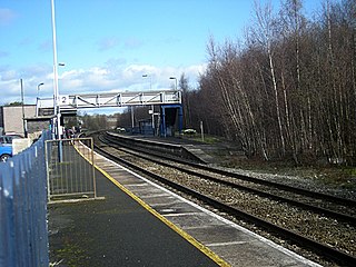
Whitchurch (Shropshire) railway station serves the town of Whitchurch in Shropshire, England. The station is 18¾ miles (30 km) north of Shrewsbury on the Welsh Marches Line. The station is maintained and served by Transport for Wales.
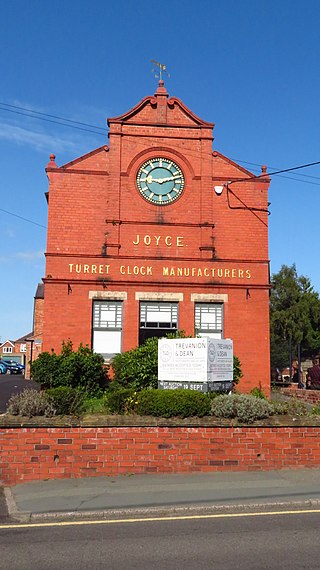
J. B. Joyce & Co, clockmakers, were founded in Shropshire in England. The company claim to be the oldest clock manufacturer in the world, originally established in 1690, and have been part of the Smith of Derby Group since 1965. The claim is challenged by another English firm of clockmakers, Thwaites & Reed, who claim to have been in continuous manufacture since before 1740, with antecedents to 1610.

Macefen is a former civil parish in the unitary authority of Cheshire West and Chester and the ceremonial county of Cheshire, England. Its area is now part of the civil parishes of Tushingham-cum-Grindley, Macefen and Bradley and No Man's Heath and District. Macefen lies 2 miles (3.2 km) east of the village of Malpas and 5 miles (8.0 km) north west of Whitchurch, Salop. Part of the village of No Man's Heath was within the northern boundary of Macefen. Its name is thought to possibly be an anglicisation of an older Welsh placename Maes-y-ffin, "the open field (maes) at the boundary (ffin)".

Hampton is a small village and former civil parish in the unitary authority of Cheshire West and Chester and the ceremonial county of Cheshire, England. According to the 2001 UK census, the total population of the civil parish was 409, decreasing marginally to 405 at the 2011 Census. The parish included Hampton Green. The civil parish was abolished in 2015 to form No Man's Heath and District, part of it also went to Malpas.
The Whitchurch and Tattenhall Railway was a line in Cheshire built by the London and North Western Railway in the 19th century. The branch, which was 14.5 mi (23.3 km) long, connected the North Wales Coast Line from Chester with the Welsh Marches line and Oswestry, Ellesmere and Whitchurch Railway at Whitchurch. Although only a branch line, the route was built to main line standards with double track along its entire length. It was used on occasion to stable the British Royal Train in sidings on the eve of official visits by members of the royal family.

Broxton railway station was a railway station near the village of Broxton, Cheshire on the Whitchurch and Tattenhall Railway.
Tattenhall railway station was a railway station in the village of Tattenhall, Cheshire on the Whitchurch and Tattenhall Railway or Chester-Whitchurch Branch Line, about a mile to the south of Tattenhall junction where the branch line diverged from the North Wales Coast Line running from Chester in the north-west towards Crewe to the south-east.

Tattenhall Road railway station was a railway station situated a mile to the north of the village of Tattenhall, Cheshire on the Chester and Crewe Railway that was built in 1840 linking Chester to the north-west with Crewe to the south-east. The track now forms part of the North Wales Coast Line.

Whittington Low Level railway station is a disused station and was one of two former railway stations in the village of Whittington, Shropshire, England.

Oswestry railway station is a Grade II listed heritage railway station in Oswestry, Shropshire, England. It was closed when passenger services were withdrawn in 1966. The station building today is used as commercial premises, although the Cambrian Railways Society are restoring it.
Whittington High Level railway station is one of two former railway stations in the village of Whittington, Shropshire, England.
