| Bukit Batu Lawi | |
|---|---|
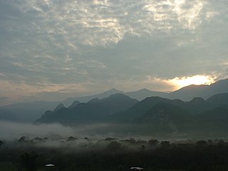
Batu Lawi, seen from the peak of Mount Murud on 4 September 1998 | |
| Highest point | |
| Elevation | 2,046 m (6,713 ft) |
| Geography | |
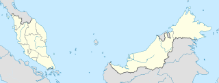
| Location | Sarawak, Borneo |
| Parent range | Kelabit Highlands |
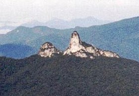
Batu Lawi is a twin-peaked mountain in the Kelabit Highlands of Sarawak, Malaysia (Borneo) that has played important roles in both ancient mythology and modern history. The taller 'male' peak is 2046 metres above sea level, while the female summit is at 1850 metres. It is one of the highest mountains in the state of Sarawak.
The Kelabit Highlands are a mountain range located in the northernmost part of Sarawak, on the island of Borneo. The highest mountains in this range are Mount Murud at 2,423 metres (7,949 ft), Bukit Batu Buli at 2,082 metres (6,831 ft), and Bukit Batu Lawi at 2,046 metres (6,713 ft).
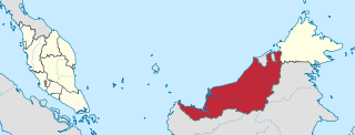
Sarawak is a state of Malaysia. Being the largest among 13 other states with the size almost equal to West Malaysia, Sarawak is located in northwest Borneo Island, and is bordered by the Malaysian state of Sabah to the northeast, Kalimantan to the south, and Brunei in the north. The capital city, Kuching, is the largest city in Sarawak, the economic centre of the state, and the seat of the Sarawak state government. Other cities and towns in Sarawak include Miri, Sibu, and Bintulu. As of the 2015 census, the population of Sarawak was 2,636,000. Sarawak has an equatorial climate with tropical rainforests and abundant animal and plant species. It has several prominent cave systems at Gunung Mulu National Park. Rajang River is the longest river in Malaysia; Bakun Dam, one of the largest dams in Southeast Asia, is located on one of its tributaries, the Balui River. Mount Murud is the highest point in Sarawak.

Malaysia is a country in Southeast Asia. The federal constitutional monarchy consists of 13 states and three federal territories, separated by the South China Sea into two similarly sized regions, Peninsular Malaysia and East Malaysia. Peninsular Malaysia shares a land and maritime border with Thailand in the north and maritime borders with Singapore in the south, Vietnam in the northeast, and Indonesia in the west. East Malaysia shares land and maritime borders with Brunei and Indonesia and a maritime border with the Philippines and Vietnam. Kuala Lumpur is the national capital and largest city while Putrajaya is the seat of federal government. With a population of over 30 million, Malaysia is the world's 44th most populous country. The southernmost point of continental Eurasia, Tanjung Piai, is in Malaysia. In the tropics, Malaysia is one of 17 megadiverse countries, with large numbers of endemic species.