County Route A1 (CR A1), more commonly known as Route of the Olympic Torch, is a 35.3-mile (56.8km) county route in Lassen County, California, United States. It gained its name as a result of being used for a portion of the 1984 Summer Olympics torch relay.
County Route A2 (CR A2), known entirely as Susanville Road, is a county route in Lassen County, California, United States, connecting SR 299 to SR 139.
Major junctions The entire route is in Lassen County.
County Route A3 (CR A3), or Standish–Buntingville Road, is a road in Lassen County, California, United States, connected to U.S. Route 395, and functions as a bypass for northbound traffic around Susanville. At its northern end it is signed for Reno (via US 395), and its southern end for Lakeview, also via US 395.
This route still serves as bypass for north–south US395 motorists, but is no longer signed as such.
Major junctions The entire route is in Lassen County.
County Route A7 (CR A7) is a road in Tehama County, California, United States, connecting Ridge Road to SR 36 in Red Bluff. The route is known as Live Oak Road, Wilder Road, and Walnut Street.
Major junctions The entire route is in Tehama County.
County Route A8 (CR A8) is a road in Tehama County, California, United States, connecting SR 99 in Los Molinos to SR 36 in Red Bluff. The route is known as Aramayo Way in Los Molinos, C Street and 5th Street in Tehama, San Benito Avenue, Road 99W or State Highway 99W (despite the old highway being a U.S. Route), and South Main Street and Main Street in Red Bluff.
The route between Proberta and Red Bluff follows the former U.S. Route 99W up to where it met up with former U.S. Route 99E (present day SR 36 / Antelope Boulevard), reuniting both with the former U.S. Route 99 (at the intersection of Main Street and Antelope Boulevard / Oak Street) in downtown Red Bluff.
Major junctions The entire route is in Tehama County.
County Route A9 (CR A9) is a road in Tehama County, California, United States, connecting Round Valley Road in Paskenta to SR 99 near Vina. The route is known as Paskenta Road, Corning Road, Solano Street in Corning, Hoag Road, Hall Road, and South Avenue.
Major junctions The entire route is in Tehama County.
County Route A10 (CR A10), known locally as "Everitt Memorial Highway", is a 15.19-mile (24.4km) long[1] county road in Siskiyou County, California, United States, near Mount Shasta. It runs from Interstate 5 in the town of Mount Shasta City to a dead end at the 8,000-foot (2,400m) level on 14,162-foot (4,317m)Mount Shasta. The route follows Lake Street, Mount Shasta Boulevard, Alma Street, and Rockfellow Drive, right before reaching Everitt Memorial Highway.
The highway, completed in 1958 at a cost of $980,000 and designated in 1959,[1] was originally built to provide access to the Mount Shasta Ski Bowl, which was destroyed by an avalanche in 1978.[3] Today, the highway provides access to Mount Shasta for climbers, skiers, and anyone wanting access to the mountain.
In wintertime, the road is kept open only to the U.S.F.S. outpost at the 6,000-foot (1,800m) level.
County Route A11 (CR A11) is a county route in Tehama County, California, United States, connecting Interstate 5 at exit 636 with CR A8 in Tehama. The route is mostly known as Gyle Road, while most of the portion within the city of Tehama is known as 5th Street.
Major junctions The entire route is in Tehama County.
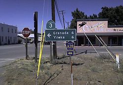
County Route A12 (CR A12), known locally as the "99-97 Cutoff", or more commonly, "the 97 cutoff", is a two-lane rural highway in Siskiyou County, California, United States, with a length of 17.9 miles (28.8km).[1] A12 begins in the west at its junction with Old 99 Highway, which was once US 99. Just a few dozen yards to the east, it intersects Interstate 5. Its eastern terminus is at US 97, 12 miles (19km) north of Weed.
CR A12
One mile east of the Interstate junction, it passes through the tiny village of Grenada, the only population center of any merit along the route. 7 miles (11km) further east is the burg Mayten, which consists only of a convenience store, a church, and an elementary school.
The route is heavily used by travelers and truckers southbound on Interstate 5 who wish to use US 97 northbound en route to Klamath Falls and points north. This route saves over 13 miles (21km) than if the alternative routing via I-5 to Weed, then north on US 97 was used. Hence, the local name "97 cutoff".
The western two-thirds of the route passes through agricultural areas, and is very reminiscent of two-lane farm roads in California's Central Valley. However, the eastern portion is very scenic, passing through an area with towering dark red crags and buttes to the north.
County Route A16 (CR A16) is a county route in Shasta County, California, United States, connecting SR 36 in Platina to SR 273 in Redding. The route is known as Platina Road, Placer Road, and Placer Street in Redding.
Known locally as "Ditch Grade Road"; the final 6.5-mile (10.5km) section before the junction with SR 36 closely follows the contour of hillside as this route was previously used to bring water to the mine at Platina. There is a rock formation some 6.5 miles (10.5km) from SR 36 known as Old Man Rock or The Lincoln Memorial.
Major junctions The entire route is in Shasta County.
County Route A17 (CR A17) is a county route in Shasta and Tehama counties in the U.S. state of California, connecting Interstate 5 near Cottonwood to SR 44 near Inwood. The route is known as Balls Ferry Road, Ash Creek Road, and Dersch Road. In Cottonwood, the route follows Main Street, Front Street, Magnolia Street, Chestnut Street, and First Street.
The southern end of CR A18 was the location of the only Shopko in the entire state of California, in Redding, which opened in 1989. The store was shuttered on May 5, 2019, as part of the chain's bankruptcy and liquidation.[5]
Major junctions The entire route is in Shasta County.
County Route A20 (CR A20), or Glenburn Road, is a county route in Shasta County, California, United States, connecting SR 89 to CR A19 (McArthur Road).
Major junctions The entire route is in Shasta County.
County Route A21 (CR A21) is a county route in Lassen County, California, United States, connecting SR 147 to SR 44, intersecting SR 36 along the way. The route is known as 3rd Street and Ash Street in Westwood and Mooney Road for the remainder of the route.
Major junctions The entire route is in Lassen County.
County Route A22 (CR A22) is a county route in Plumas County, California, United States, connecting SR 89 in Crescent Mills to Taylorsville. The route is mostly known as Arlington Road, along with a small section of Main Street in Taylorsville.
Major junctions The entire route is in Plumas County.
County Route A23 (CR A23) is a county route in Plumas and Sierra counties in the U.S. state of California, connecting SR 49 / SR 89 near Sattley to SR 70 near Beckwourth passing through the Sierra Valley on its west side. In the northerly direction, CR A23 begins at the junction of SR 49 / SR 89 at Sattley, formerly known as Church's Corners, which is a census-designated place in Sierra County. The road leaves Sattley as Westside Road. It passes near Calpine, a census-designated place also in Sierra County, where the road becomes Beckwourth-Calpine Road and continues to SR 70 near Beckwourth, a census-designated place in Plumas County.
County Route A24 (CR A24) is a county route in Plumas and Sierra counties in the U.S. state of California, connecting SR 49 in Loyalton to SR 70 in Hawley. The route is known as 3rd Street and Beckwith Street in Loyalton, Beckwith Road, Sierra Valley Road, Dyson Lane, and Beckworth Loyalton Road.
County Route A28 (CR A28) is a two-lane rural highway in Siskiyou County, California, United States, connecting CR A12 (the 99-97 Cutoff) to Copco Road near Hornbrook. The route is known as Montague Grenada Road, 11th Street in Montague, and Ager Road.
CR A28 begins at CR A12 in Grenada, connecting Grenada with Interstate 5 near Hornbrook via Montague. It is a flat, level route, and for this reason, was the original preferred routing for both US 99 and I-5 through the area. In both instances, the routing was changed because of intense lobbying by officials in Yreka, who decried the fact that the major highway through the county would bypass the county seat. Thus, both highways ended up being built over far more rigorous terrain at a huge cost increase.
A28 serves the aforementioned three towns, as well as numerous homes and ranches along the way.
This page is based on this Wikipedia article Text is available under the CC BY-SA 4.0 license; additional terms may apply. Images, videos and audio are available under their respective licenses.