Related Research Articles

Dyfed is a preserved county in southwestern Wales. It is a mostly rural area with a coastline on the Irish Sea and the Bristol Channel.

Carmarthenshire is a county in the south-west of Wales. The three largest towns are Llanelli, Carmarthen and Ammanford. Carmarthen is the county town and administrative centre. The county is known as the "Garden of Wales" and is also home to the National Botanic Garden of Wales.

The River Towy is one of the longest rivers flowing entirely within Wales. Its total length is 120 km (75 mi). It is noted for its sea trout and salmon fishing.

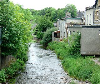
The River Teifi in Wales forms the boundary for most of its length between the counties of Ceredigion and Carmarthenshire, and for the final 3 miles (4.8 km) of its total length of 76 miles (122 km), the boundary between Ceredigion and Pembrokeshire. Its estuary is northwest of Cardigan. Teifi has formerly been anglicised as "Tivy".

The Teifi Valley Railway is a 2 ft narrow gauge railway occupying a section of the former standard gauge Great Western Railway line between Llandysul and Newcastle Emlyn. After the closure of the former line by British Rail in 1973, a preservation group built and periodically extended a narrow-gauge railway along the route, westwards from Henllan, eventually operating a 3 kilometres (1.9 mi) long line as a tourist attraction.

The A475 road in Wales links Newcastle Emlyn in Carmarthenshire with Lampeter in Ceredigion; a distance of 19 miles (31 km).

Afon Cych is a tributary of the River Teifi in south-west Wales. It is 13 km long, passes through a number of small settlements on the border between Pembrokeshire and Carmarthenshire, and is significant in Welsh legend.

The River Dulas is a tributary of the River Teifi and has its source near the village of Llangybi, Ceredigion, Wales. Its confluence with the Teifi is near Lampeter.
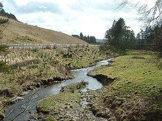
The River Brenig is a tributary river of the River Teifi and runs through the market town of Tregaron in Ceredigion, Wales. It is formed from the confluence of the Afon Groes and Afon Berwyn in the foothills of the Cambrian Mountains.
This is a list of the extreme points and extreme elevations in Wales.
The Afon Llynfi is a short river in the county of Powys, south Wales. A tributary of the River Wye, it runs approximately south to north just to the west of the Black Mountains and partly within the Brecon Beacons National Park.

This is a list of the longest rivers of the United Kingdom.

The Afon Twrch is a short river in Carmarthenshire, West Wales. It joins the River Cothi at the village of Pumsaint, near to which are the Roman gold mines of Dolaucothi.
The Camddwr is a right-bank tributary of the River Teifi in Ceredigion, mid Wales. It rises to the west of the village of Bronnant and flows in a generally southeasterly direction to join the Teifi at Cors Caron, an extensive inland marsh protected as a national nature reserve. Its tributary streams include the right-bank ones of Afon Talfryn, Afon Hirfain, Nant yr Efail and Nant Tyn-y-swydd and Camddwr fach which enters on its left bank.
The River Ithon is a major left-bank tributary of the River Wye in Powys, mid Wales. It rises in the broad saddle between the western end of Kerry Hill and the hill of Glog to its west and flows initially southwards to Llanbadarn Fynydd. It then takes a twisting route south via the villages of Llanbister, Llanddewi Ystradenny and Penybont before turning southwest, then doubling back northwards towards Crossgates. From here it resumes a southwesterly course, flowing past Llandrindod Wells and the site of Cefnllys Castle to a confluence with the Wye, 1 mile to the south of Newbridge-on-Wye.

The Afon Gwili is a right-bank tributary of the River Loughor in the east of Carmarthenshire, South Wales. It rises near Cross Hands before flowing in a generally southerly direction past the small village of Cwmgwili to join with the Loughor beyond Hendy near Pontarddulais.

Afon Irfon is a river in Powys, Wales. It flows from the upper slopes of Bryn Garw in the Cambrian Mountains, through the Abergwesyn Valley, past the Nant Irfon National Nature Reserve in the hills above the village of Abergwesyn, and through Llanwrtyd Wells to its confluence with the River Wye at Builth Wells. The source of the Irfon is in the so-called 'Desert of Wales'.

Elenydd is an upland area of Mid Wales, extending across parts of northern and eastern Ceredigion and Powys between Aberystwyth and Rhayader. Elenydd is also a name given to the medieval commote of Cwmwd Deuddwr which covered approximately the same area.

The Afon Elan is a tributary of the River Wye which runs through the wide expanse of upland moors, traditionally known as Elenydd, in central Wales. Its valley is the Elan Valley. The name probably arises from elain meaning 'hind' or 'fawn' in reference perhaps to the rushing, bounding nature of its course.
References
- ↑ Ordnance Survey 1:25,000 scale Explorer map sheet 187 Llandovery
Coordinates: 52°11′39″N3°47′45″W / 52.1943°N 3.7957°W
