Canterbury, New Brunswick

Last updated

Canterbury
Canterbury NB.JPG
Canterbury Main Street
Canada New Brunswick location map 2.svg
Red pog.svg
Canterbury
Coordinates: 45°53′21″N67°27′50″W / 45.88903°N 67.46378°W / 45.88903; -67.46378
CountryCanada
Province New Brunswick
County York
Parish Canterbury
Municipality Lakeland Ridges
Incorporated1966
Area
[1]
  Land5.32 km2 (2.05 sq mi)
Population
 (2021) [1]
  Total320
  Density60.2/km2 (156/sq mi)
  Change (2016–21)
Decrease2.svg 4.8%
Time zone UTC-4 (EST)
  Summer (DST) UTC-3 (EDT)
Website Canterbury Website

Canterbury is a former village in York County, in the Canadian province of New Brunswick. It held village status prior to 2023 and is now part of the village of Lakeland Ridges. The community is west of the Trans-Canada Highway at the intersection of Route 122 and Route 630.

Contents

It is named for Thomas Manners-Sutton (1814–77), later third Viscount Canterbury, who served as Lieutenant-Governor of New Brunswick from 1854-1861. Parrish erected in 1855. [2]

History

Tracing its roots to the forestry and railway industries, Canterbury was once home to over 1,000 residents and served as a service centre for the surrounding area of western York County. There were at least three general stores, a small department store, a railway hotel, bank, and a butcher as late as the mid-1960s, but they are all gone now.

Early settlers of the area were Loyalists ( possibly disbanded soldiers of the King's American Regiment and their families ) displaced by the end of the American Revolution (1780s) later augmented by immigrants from Ireland (Ulster, circa 1840).

In the winter of 1865, Canterbury was briefly the focus of much military activity when some 9000 British troops passed through the village on their way to "The Canadas" (Ontario and Quebec). The British government had become alarmed about the possibility of an American invasion following the end of the American Civil War and sent this military contingent to reinforce the garrisons in The Canadas. As it was winter, the shipping season in the St. Lawrence River was closed leaving overland travel from British colonies in the Maritimes as the only option. The closest rail connection to Quebec from the Atlantic coast in the 1860s was the New Brunswick and Canada Railway line extending from the port of St. Andrews through Canterbury to the end of rails in nearby Richmond Corner. The large contingent of British troops debarked passenger trains at the station and were then driven by horse-drawn sleigh up the Saint John River and then across to St Lawrence to Levis (opposite Quebec City) where they re-boarded passenger trains operated by the Grand Trunk Railway.

Prior to 1966 Canterbury was a local improvement district governed by a chairman and secretary and 3 councillors and then in 1966, it was incorporated as a village, with a mayor, secretary and 3 councillors later adding a fourth councillor and at present has a village office on Main Street.

On 1 January 2023, Canterbury amalgamated with the village of Meductic and all or part of five local service districts to form the new village of Lakeland Ridges. [3] [4] The community's name remains in official use. [5]

Demographics

In the 2021 Census of Population conducted by Statistics Canada, Canterbury had a population of 320 living in 135 of its 142 total private dwellings, a change of

Historical populations:
Canterbury, NB
YearPop.±%
2001 399    
2006 360−9.8%
2011 336−6.7%
2016 336+0.0%
2021320−4.8%
Source: [6] [7] [1]

Infrastructure

The New Brunswick and Canada Railway extended the former St. Andrews and Quebec Railway line to Canterbury in 1859, placing Canterbury roughly halfway between Woodstock to the north and McAdam to the south. The New Brunswick and Canada Railway was purchased by the New Brunswick Railway in 1882. In 1890, the New Brunswick Railway was purchased by the Canadian Pacific Railway, which operated the line through Canterbury to serve its rail network in the upper Saint John River valley until rail service was abandoned in the early 1990s. The original CPR passenger station on Water Street in Canterbury was demolished in the 2000s and the rail line is now a rail trail and part of the Sentier NB Trail system.

Education

Canterbury has a school called Canterbury High School, which educates students from kindergarten to grade 12 all in one building. The school has escaped closure several times but had its future sealed in 2002 with an extensive construction overhaul and addition of a new gym. Prior to 1975, Canterbury High School held grades 7–12, The Old Green School house beside Mill Street housed Grade 1, 2, 3 and 6 and Grades 4 and 5 were held in Meductic School.

Notable people

See also

Related Research Articles

<span class="mw-page-title-main">Fredericton</span> Capital city of New Brunswick, Canada

Fredericton is the capital city of the Canadian province of New Brunswick. The city is situated in the west-central portion of the province along the Saint John River, also known by its Indigenous name of Wolastoq, which flows west to east as it bisects the city. The river is the dominant natural feature of the area. One of the main urban centres in New Brunswick, the city had a population of 63,116 and a metropolitan population of 108,610 in the 2021 Canadian Census. It is the third-largest city in the province after Moncton and Saint John.

<span class="mw-page-title-main">Miramichi, New Brunswick</span> City in New Brunswick, Canada

Miramichi ( ) is the largest city in northern New Brunswick, Canada. It is situated at the mouth of the Miramichi River where it enters Miramichi Bay. The Miramichi Valley is the second longest valley in New Brunswick, after the Saint John River Valley.

<span class="mw-page-title-main">Edmundston</span> City in New Brunswick, Canada

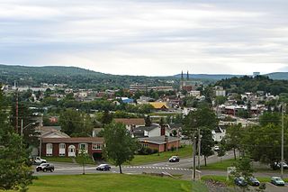
Edmundston is a city in Madawaska County, New Brunswick, Canada. Established in 1850, it had a population of 16,437 as of 2021.

<span class="mw-page-title-main">Cornwall, Ontario</span> City in Ontario, Canada

Cornwall is a city in Eastern Ontario, Canada, situated where the provinces of Ontario and Quebec and the state of New York converge. It is the seat of the United Counties of Stormont, Dundas, and Glengarry and is Ontario's easternmost city.

<span class="mw-page-title-main">St. Stephen, New Brunswick</span> Town in New Brunswick, Canada

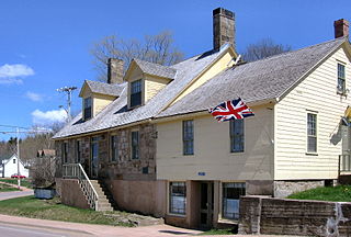
St. Stephen is a Canadian town in Charlotte County, New Brunswick, situated on the east bank of the St. Croix River around the intersection of New Brunswick Route 170 and the southern terminus of New Brunswick Route 3. The St. Croix River marks a section of the Canada–United States border, forming a natural border between Calais, Maine and St. Stephen. U.S. Route 1 parallels the St. Croix river for a few miles, and is accessed from St. Stephen by three cross-border bridges.

<span class="mw-page-title-main">Kawartha Lakes</span> City in Ontario, Canada

The City of Kawartha Lakes is a unitary municipality in Central Ontario, Canada. It is a municipality legally structured as a single-tier city; however, Kawartha Lakes is the size of a typical Ontario county and is mostly rural. It is the second largest single-tier municipality in Ontario by land area.

<span class="mw-page-title-main">Dorchester, New Brunswick</span> Place in New Brunswick, Canada

Dorchester is a community in Westmorland County, New Brunswick, Canada. The community became part of the new town of Tantramar in the 2023 New Brunswick local governance reform. Originally incorporated as a town in 1911, it was converted to a village in 1966. By 1825 it had been named for Guy Carleton, 1st Baron Dorchester, an 18th-century Governor-General of the old Province of Quebec, but prior to that was called Botsford.

<span class="mw-page-title-main">Tracadie-Sheila</span> Former town in New Brunswick, Canada

Tracadie-Sheila is a former town in Gloucester County, New Brunswick, Canada. It is now part of the Regional Municipality of Tracadie.

<span class="mw-page-title-main">Hampton, New Brunswick</span> Town in New Brunswick, Canada

Hampton is a town in Kings County, New Brunswick, Canada.

<span class="mw-page-title-main">Guelph/Eramosa</span> Township in Ontario, Canada

Guelph/Eramosa is a township located in Wellington County, in midwestern Ontario, Canada. It partly encircles the city of Guelph, surrounding it in a continuous arc from approximately northeast to south-southwest of the city. It is part of the Guelph census metropolitan area.

Dalhousie is a former town located in Northern New Brunswick. On January 1, 2023, Dalhousie merged with the village of Charlo and all or part of five local service districts (LSDs) to form the new town of Heron Bay, named Baie-des-Hérons in French. Heron Bay is New Brunswick's northernmost point of land.

<span class="mw-page-title-main">Saint-Quentin, New Brunswick</span> Town in New Brunswick, Canada

Saint-Quentin is a town in northern New Brunswick, Canada.

<span class="mw-page-title-main">McAdam, New Brunswick</span> Village in New Brunswick, Canada

McAdam is a village located in the southwestern corner of York County, New Brunswick, Canada. The village covers 14.28 square kilometres (5.51 sq mi) and had a population of 1,151 as of 2016. An independent study was executed early 2018, and the results found that the population of McAdam had grown to 1,225. Turning the tide of a shrinking population, this is the first time the community's population grew since 1956.

Meductic is a former village along the Saint John River in southern New Brunswick, Canada. It held village status prior to 2023 and is now part of the village of Lakeland Ridges. It is approximately 33 kilometres southeast of Woodstock.

Kingswear is a village and civil parish in the South Hams area of the English county of Devon. The village is located on the east bank of the tidal River Dart, close to the river's mouth and opposite the small town of Dartmouth. It lies within the South Devon Area of Outstanding Natural Beauty, and has a population of 1,332, reducing to 1,217 at the 2011 census.

<span class="mw-page-title-main">Aroostook, New Brunswick</span> Place in New Brunswick, Canada

Aroostook is a former village in Victoria County, New Brunswick, Canada. It held village status prior to 2023. It is now part of the village of Southern Victoria.

<span class="mw-page-title-main">Blackville, New Brunswick</span> Place in New Brunswick, Canada

Blackville is a former village in Northumberland County, New Brunswick, Canada. It is now part of the rural community of Miramichi River Valley.

<span class="mw-page-title-main">Harvey, New Brunswick</span> Rural community in New Brunswick, Canada

Harvey is a community in York County, in the Canadian province of New Brunswick, formerly an incorporated village but now part of an incorporated rural community of the same name. It is often called Harvey Station.

<span class="mw-page-title-main">Canterbury Parish, New Brunswick</span> Parish in New Brunswick, Canada

Canterbury is a geographic parish in York County, New Brunswick, Canada.

<span class="mw-page-title-main">Lakeland Ridges</span> Village in New Brunswick, Canada

Lakeland Ridges is a village municipality in the Canadian province of New Brunswick. The jurisdiction was formed through the 2023 New Brunswick local governance reforms which saw the consolidation of local government entities into regions or districts.

References

  1. 1 2 3 4 "Census Profile of Canterbury". Statistics Canada. 6 December 2022. Retrieved 15 January 2023.
  2. Hamilton, William (1978). The Macmillan Book of Canadian Place Names. Toronto: Macmillan. p. 72. ISBN   0-7715-9754-1.
  3. "Local Governments Establishment Regulation – Local Governance Act". Government of New Brunswick. 12 October 2022. Retrieved 20 January 2023.
  4. "RSC 12 - Western Valley Regional Service Commission". Government of New Brunswick. Retrieved 20 January 2023.
  5. "Proposed entity names reflect strong ties to nature and history" (Press release). Irishtown, New Brunswick: Government of New Brunswick. 25 May 2022. Retrieved 20 January 2023.
  6. "2006 Community Profiles: Canterbury, New Brunswick". Statistics Canada. Retrieved October 6, 2019.
  7. "Census Profile, 2016 Census: Canterbury, Village [Census subdivision], New Brunswick". Statistics Canada. Retrieved October 6, 2019.