Canterbury Parish, New Brunswick

Last updated

Canterbury
York County NB - Canterbury Parish.PNG
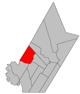
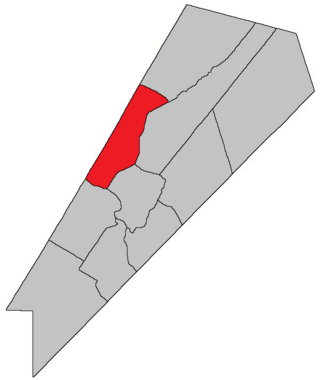
Location within York County, New Brunswick.
Coordinates: 45°50′42″N67°32′06″W / 45.845°N 67.535°W / 45.845; -67.535
Country Flag of Canada (Pantone).svg  Canada
Province Flag of New Brunswick.svg  New Brunswick
County York
Erected1855
Area
[1]
  Land550.70 km2 (212.63 sq mi)
Population
 (2021) [1]
  Total552
  Density1.0/km2 (3/sq mi)
  Change 2016-2021
Increase2.svg 5.1%
  Dwellings
419
Time zone UTC-4 (AST)
  Summer (DST) UTC-3 (ADT)
Figures do not include portions within the villages of Canterbury and Meductic

Canterbury is a geographic parish in York County, New Brunswick, Canada. [2]

Contents

Prior to the 2023 governance reform, for governance purposes it was divided between the villages of Canterbury and Meductic and the local service districts of Benton and the parish of Canterbury, [3] all of which were members of the Western Valley Regional Service Commission (WVRSC). [4]

Origin of name

The parish was named in honour of John Manners-Sutton, [5] Lieutenant Governor of New Brunswick at the time and later 3rd Viscount Canterbury following the death of his brother. Manners Sutton Parish (originally Manners-Sutton) was erected at the same time.

History

Canterbury was erected in 1855 from Dumfries Parish. [6] An oversight omits Falls Island in the Saint John River, leaving it outside the boundaries of both Canterbury and Dumfries.

In 1879 the rear of Canterbury was erected as North Lake Parish. [7]

In 1957 Fall Island in the Saint John River was stated to belong to Canterbury. [8]

Boundaries

Canterbury Parish is bounded: [2] [9] [10]

Communities

Communities at least partly within the parish. [9] [10] [11] bold indicates an incorporated municipality

Bodies of water

Bodies of water [lower-alpha 1] at least partly within the parish. [9] [10] [11]

Islands

Islands at least partly within the parish. [9] [10] [11]

Other notable places

Parks, historic sites, and other noteworthy places at least partly within the parish. [9] [10] [11] [12]

Demographics

Parish population total does not include the former incorporated village of Canterbury and the portion within the former incorporated village of Meductic. Revised census figures based on the 2023 local governance reforms have not been released.

See also

Notes

  1. Not including brooks, ponds or coves.

Related Research Articles

<span class="mw-page-title-main">Waterborough Parish, New Brunswick</span> Parish in New Brunswick, Canada

Waterborough is a geographic parish in Queens County, New Brunswick, Canada.

<span class="mw-page-title-main">Queensbury Parish, New Brunswick</span> Parish in New Brunswick, Canada

Queensbury is a geographic parish in York County, New Brunswick, Canada.

<span class="mw-page-title-main">Dumfries Parish, New Brunswick</span> Parish in New Brunswick, Canada

Dumfries is a geographic parish in York County, New Brunswick, Canada.

<span class="mw-page-title-main">Southampton Parish, New Brunswick</span> Parish in New Brunswick, Canada

Southampton is a geographic parish in York County, New Brunswick, Canada.

<span class="mw-page-title-main">Saint-François Parish, New Brunswick</span> Parish in New Brunswick, Canada

Saint-François is a geographic parish in Madawaska County, New Brunswick, Canada.

<span class="mw-page-title-main">Northesk Parish, New Brunswick</span> Parish in New Brunswick, Canada

Northesk is a geographic parish in Northumberland County, New Brunswick, Canada.

<span class="mw-page-title-main">Southesk Parish, New Brunswick</span> Parish in New Brunswick, Canada

Southesk is a geographic parish in Northumberland County, New Brunswick, Canada.

<span class="mw-page-title-main">Harcourt Parish, New Brunswick</span> Parish in New Brunswick, Canada

Harcourt is a geographic parish in Kent County, New Brunswick, Canada.

<span class="mw-page-title-main">Brighton Parish, New Brunswick</span> Parish in New Brunswick, Canada

Brighton is a geographic parish in Carleton County, New Brunswick, Canada, northeast of Woodstock, extending from the eastern bank of the Saint John River to the York County line.

<span class="mw-page-title-main">Woodstock Parish, New Brunswick</span> Parish in New Brunswick, Canada

Woodstock is a geographic parish in Carleton County, New Brunswick, Canada, surrounding the town of the same name on its landward side.

<span class="mw-page-title-main">North Lake Parish, New Brunswick</span> Parish in New Brunswick, Canada

North Lake is a geographic parish in York County, New Brunswick, Canada.

<span class="mw-page-title-main">McAdam Parish, New Brunswick</span> Parish in New Brunswick, Canada

McAdam is a geographic parish in York County, New Brunswick, Canada.

<span class="mw-page-title-main">Prince William Parish, New Brunswick</span> Parish in New Brunswick, Canada

Prince William is a geographic parish in York County, New Brunswick, Canada.

<span class="mw-page-title-main">Manners Sutton Parish, New Brunswick</span> Parish in New Brunswick, Canada

Manners Sutton is a geographic parish in York County, New Brunswick, Canada.

<span class="mw-page-title-main">Douglas Parish, New Brunswick</span> Parish in New Brunswick, Canada

Douglas is a geographic parish in York County, New Brunswick, Canada.

<span class="mw-page-title-main">Musquash Parish, New Brunswick</span> Parish in New Brunswick, Canada

Musquash is a geographic parish in Saint John County, New Brunswick, Canada.

<span class="mw-page-title-main">Lepreau Parish, New Brunswick</span> Parish in Canada

Lepreau is a geographic parish in Charlotte County, New Brunswick, Canada, west of Saint John.

<span class="mw-page-title-main">Canning Parish, New Brunswick</span> Parish in New Brunswick, Canada

Canning is a geographic parish in Queens County, New Brunswick, Canada.

<span class="mw-page-title-main">Sheffield Parish, New Brunswick</span> Parish in New Brunswick, Canada

Sheffield is a geographic parish in Sunbury County, New Brunswick, Canada.

<span class="mw-page-title-main">Saint James Parish, New Brunswick</span> Parish in Canada

Saint James is a geographic parish in Charlotte County, New Brunswick, Canada, located north of St. Stephen.

References

  1. 1 2 "Census Profile". Statistics Canada. 26 October 2022. Retrieved 29 October 2022.
  2. 1 2 "Chapter T-3 Territorial Division Act". Government of New Brunswick. Retrieved 13 November 2020.
  3. "New Brunswick Regulation 84-168 under the Municipalities Act (O.C. 84-582)". Government of New Brunswick. Retrieved 25 July 2020.
  4. "Communities in each of the 12 Regional Service Commissions (RSC) / Les communautés dans chacune des 12 Commissions de services régionaux (CSR)" (PDF), Government of New Brunswick, July 2017, retrieved 1 February 2021
  5. "Canterbury Parish". Provincial Archives of New Brunswick. Retrieved 24 October 2020.
  6. "18 Vic. c. 45 An Act to erect a part of the Parish of Dumfries, in the County of York, into a separate Town or Parish.". Acts of the General Assembly of Her Majesty's Province of New Brunswick, Passed in the Month of November, 1854, and in the Months of February, March, and April, 1855. Fredericton: Government of New Brunswick. 1855. pp. 174–175. Available as a free ebook from Google Books.
  7. "42 Vic. c. 42 An Act to erect part of the Parish of Canterbury, in the County of York, into a separate Parish.". Acts of the General Assembly of Her Majesty's Province of New Brunswick. Passed in the Month of April 1879. Fredericton: Government of New Brunswick. 1879. pp. 84–85. Available as a free ebook from Google Books.
  8. "6 Elizabeth II, 1957, c. 63 An Act to Amend the Territorial Division Act". Acts of the Legislature of New Brunswick Passed During the Session of 1957. Fredericton: Government of New Brunswick. 1957. p. 201.
  9. 1 2 3 4 5 "No. 123". Provincial Archives of New Brunswick. Department of Natural Resources and Energy Development. Retrieved 25 June 2021. Remainder of parish on maps 124, 134, and 135 at same site.
  10. 1 2 3 4 5 "365" (PDF). Transportation and Infrastructure. Government of New Brunswick. Retrieved 25 June 2021. Remainder of parish on mapbooks 366, 367, 385–387, 404, 405, and 423 at same site.
  11. 1 2 3 4 "Search the Canadian Geographical Names Database (CGNDB)". Government of Canada. Retrieved 3 July 2021.
  12. "Explore New Brunswick's Protected Natural Areas". GeoNB. Retrieved 3 July 2021.
  13. Statistics Canada: 1996, 2001, 2006 census
  14. 2006 Statistics Canada Community Profile: Canterbury Parish, New Brunswick
  15. 2011 Statistics Canada Census Profile: Canterbury Parish, New Brunswick
  16. 1 2 "Census Profile, 2016 Census: Canterbury, Parish [Census subdivision], New Brunswick". Statistics Canada. Retrieved 7 October 2019.


45°50′42″N67°32′06″W / 45.84500°N 67.53500°W / 45.84500; -67.53500 (Canterbury Parish, New Brunswick)