The Delaware River is a major river in the Mid-Atlantic region of the United States and is the longest free-flowing (undammed) river in the Eastern United States. From the meeting of its branches in Hancock, New York, the river flows for 282 miles (454 km) along the borders of New York, Pennsylvania, New Jersey, and Delaware, before emptying into Delaware Bay.

Orange County is a county located in the U.S. state of New York. As of the 2020 census, the population was 401,310. The county seat is Goshen. This county was first created in 1683 and reorganized with its present boundaries in 1798. The county is part of the Hudson Valley region of the state.

Deerpark is a town in the western part of Orange County, New York, United States, and part of the New York metropolitan area. As of the 2020 Census, the population was at 7,509. The center of population of New York is located in Cuddebackville, a hamlet in Deerpark. Cuddebackville and Deerpark most prominently serve as the headquarters of both the global Falun Gong religious movement and the Shen Yun performance arts troupe, based at the Dragon Springs compound.
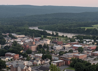
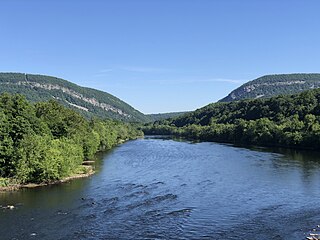
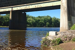
Port Jervis is a city located at the confluence of the Neversink and Delaware rivers in western Orange County, New York, United States, north of the Delaware Water Gap. Its population was 8,775 at the 2020 census. The communities of Deerpark, Huguenot, Sparrowbush, and Greenville are adjacent to Port Jervis. Matamoras, Pennsylvania, is across the river and connected by the Mid-Delaware Bridge. Montague Township, New Jersey, also borders the city. The Tri-States Monument, marking the tripoint between New York, New Jersey, and Pennsylvania, lies at the southwestern corner of the city.

Matamoras is a borough in Pike County, Pennsylvania, United States. The population was 2,362 at the 2020 census. It is the easternmost municipality of any kind in Pennsylvania. Matamoras is part of the New York–Newark–Jersey City, NY–NJ–PA Metropolitan Statistical Area, as well as the larger New York–Newark, NY–NJ–CT–PA Combined Statistical Area.

The Ramapo River is a tributary of the Pompton River, approximately 30 mi (48 km) long, in southern New York and northern New Jersey in the United States.
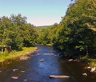
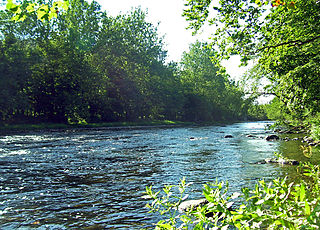
The Neversink River is a 55-mile-long (89 km) tributary of the Delaware River in southeastern New York in the United States. The name of the river comes from the corruption of an Algonquian language phrase meaning "mad river."
The Cuddebackville Dam was a concrete dam on the Neversink River in Deerpark, Orange County, New York near the town of Cuddebackville, New York, removed in October, 2004 to benefit aquatic life. It was the first dam removed in New York State for environmental reasons.

The Delaware and Hudson Canal was the first venture of the Delaware and Hudson Canal Company, which would later build the Delaware and Hudson Railway. Between 1828 and 1899, the canal's barges carried anthracite coal from the mines of northeastern Pennsylvania to the Hudson River and thence to market in New York City.
Bridgeville is a hamlet southeast of Monticello located in the southern Catskill Mountains in the Town of Thompson, County of Sullivan, and State of New York, United States. Bridgeville is located on the Neversink River on New York State Route 17, at an elevation of 1,081 feet (329 m). It has hilly terrain.

The Line of Property is the name commonly given to the line dividing Indian lands from those of the Thirteen Colonies, which were established in the 1768 Treaty of Fort Stanwix between British officials and the Iroquois tribes. In western Pennsylvania, it is referred to as the Purchase line.
The New York–Pennsylvania border is the state line between the U.S. states of New York and Pennsylvania. It has three sections:

Westbrookville is a hamlet in the town of Deerpark in Orange County, New York, United States, along US 209. Westbrookville was named for Dirck Van Keuren Westbrook, an early settler. Fort Westbrook, dating back to the American Revolution, is extant. The 1900–1940 US Census lists it as part of Mamakating in Sullivan County. Situated between Port Jervis and Wurtsboro, it is close to the borders of Pennsylvania and New Jersey. Westbrookville is located within the Port Jervis City School District. It contains many small businesses and Westbrookville Cemetery.

New Jersey is a state within the United States of America that lies on the north eastern edge of the North American continent. It shares a land border with the state of New York along the north, ratified by both states after the New York – New Jersey Line War, which is its only straight line border.
The Stillwater Presbyterian Church was a congregation of the Presbyterian Church (USA) located in the village of Stillwater in Stillwater Township of Sussex County, New Jersey, in the United States. It was a member of the Presbytery of the Highlands. Founded in 1769 as a union church shared by members of the Reformed and Lutheran faiths, the parish, now Presbyterian, closed in 2019.

Greeley is a town in Pike County, Pennsylvania, United States, approximately halfway between Milford and Hawley. Its population is 1322. Lake Greeley Camp is named after this town, and is situated on Lake Greeley.

The New York – New Jersey Line War was a series of skirmishes and raids that took place for over half a century between 1701 and 1765 at the disputed border between two American colonies, the Province of New York and the Province of New Jersey.

The Minisink or Minisink Valley is a loosely defined geographic region of the Upper Delaware River valley in northwestern New Jersey, northeastern Pennsylvania and New York.
Basher Kill is a stream in Orange and Sullivan counties in the U.S. state of New York. It is a tributary to the Neversink River.

The Tri-States Monument is a granite monument that marks the tripoint of the state boundaries of New Jersey, New York, and Pennsylvania. It is at the northwestern end of the boundary between New Jersey and New York, the northern end of the boundary between New Jersey and Pennsylvania, and the eastern end of the boundary between New York and Pennsylvania. The monument is located at the confluence of the Delaware and Neversink rivers. This location is also known as Carpenter's Point.

