Cashtown-McKnightstown | |
---|---|
Coordinates: 39°52′33″N77°20′17″W / 39.87583°N 77.33806°W | |
Country | United States |
State | Pennsylvania |
County | Adams |
Area | |
• Total | 2.4 sq mi (6 km2) |
• Land | 2.4 sq mi (6 km2) |
Population (2010) | |
• Total | 685 |
• Density | 290/sq mi (110/km2) |
Time zone | UTC-5 (Eastern (EST)) |
• Summer (DST) | UTC-4 (EDT) |
ZIP codes | 17353, 17310, 17343, 17307 |
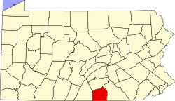
Cashtown-McKnightstown was a census-designated place (CDP) in Franklin Township, Adams County, Pennsylvania. It was the 2000 United States Census area designated by obsolete Census Code 11588 [1] and has been replaced by the CDPs of Cashtown [2] and McKnightstown, [3] which the USGS designated as separate named places on August 30, 2010.
Cashtown-McKnightstown is located at 39°52′33″N77°20′17″W / 39.87583°N 77.33806°W (39.875934, -77.338137). [4]
According to the United States Census Bureau, the CDP has a total area of 2.4 square miles (6.2 km2), all of it land.
In 1863 during the Civil War, General Robert E. Lee and the Army of Northern Virginia passed through Cashtown on its way to Gettysburg, and a few generals made their headquarters at the Cashtown Inn during the battle. After Lee's failure to defeat General Meade and the Army of the Potomac at the Battle of Gettysburg (July 1–3), Lee once again passed through Cashtown during the early morning hours of July 4, 1863 in heavy rain in his retreat to Virginia.
As of the census [5] of 2000, there were 753 people, 289 households, and 223 families residing in the CDP. The population density was 315.9 inhabitants per square mile (122.0/km2). There were 300 housing units at an average density of 125.9 per square mile (48.6/km2). The racial makeup of the CDP was 95.75% White, 1.73% African American, 0.93% from other races, and 1.59% from two or more races. Hispanic or Latino of any race were 0.93% of the population.
There were 289 households, out of which 30.1% had children under the age of 18 living with them, 65.7% were married couples living together, 9.3% had a female householder with no husband present, and 22.8% were non-families. 20.8% of all households were made up of individuals, and 10.4% had someone living alone who was 65 years of age or older. The average household size was 2.61 and the average family size was 3.03.
In the CDP, the population was spread out, with 24.4% under the age of 18, 6.4% from 18 to 24, 27.5% from 25 to 44, 27.4% from 45 to 64, and 14.3% who were 65 years of age or older. The median age was 40 years. For every 100 females, there were 93.1 males. For every 100 females age 18 and over, there were 92.9 males.
The median income for a household in the CDP was $45,882, and the median income for a family was $49,732. Males had a median income of $35,382 versus $18,864 for females. The per capita income for the CDP was $19,105. None of the families and 0.9% of the population were living below the poverty line, including no under eighteens and 6.9% of those over 64.
North Fort Myers is an unincorporated area and census-designated place (CDP) in Lee County, Florida, United States. The population was 42,719 at the 2020 census. It is part of the Cape Coral-Fort Myers, Florida Metropolitan Statistical Area.
Maugansville is a census-designated place (CDP) in Washington County, Maryland, United States. The population was 2,295 at the 2000 census.
Ogden is a census-designated place (CDP) in New Hanover County, North Carolina, United States. It is both a suburb of the city of Wilmington and part of the Wilmington Metropolitan Statistical Area. The population was 6,766 at the 2010 census, up from 5,481 in 2000.
Sherwood is a census-designated place (CDP) in Hamilton County, Ohio, United States. The population was 3,633 at the 2020 census.
Roseburg North is a census-designated place (CDP) in Douglas County, Oregon, United States. The population was 5,912 at the 2010 census. Winchester, Oregon is included as part of Roseburg North.
Altamont is a census-designated place (CDP) and unincorporated community in Klamath County, Oregon, United States, southeast of Klamath Falls. As of the 2010 Census, the population was 19,257. All mailing addresses in Altamont are Klamath Falls addresses, although Altamont is outside of the city limits of Klamath Falls.
Rose Lodge is a census-designated place (CDP) and unincorporated community in Lincoln County, Oregon, United States, along the 45th parallel. The population was 1,894 at the 2010 census.
Gopher Flats is a census-designated place (CDP) in Umatilla County, Oregon, United States. The population was 401 at the 2000 census. It is part of the Pendleton–Hermiston Micropolitan Statistical Area.
Aspers is a census-designated place in Adams County, Pennsylvania, United States. As of the 2020 census, it had a population of 486. At the 2000 census it was listed as the Bendersville Station-Aspers CDP.
Franklin Township is a township in Adams County, Pennsylvania, United States. The population was 4,676 at the 2020 census.
Lake Heritage is a census-designated place (CDP) in Adams County, Pennsylvania, United States. Its population was 2,158 at the 2020 census.
Fayetteville is an unincorporated community and census-designated place (CDP) in Franklin County, Pennsylvania, United States. The population was 3,208 at the 2020 census.
Avon is a census-designated place (CDP) in Cache County, Utah, United States. The population was 367 at the 2010 census. It is included in the Logan, Utah-Idaho (partial) Metropolitan Statistical Area.
Chamberlayne is a census-designated place (CDP) in Henrico County, Virginia, United States. The population was 5,581 at the 2020 census.
Wyndham is a census-designated place (CDP) in Henrico County, Virginia, United States, in the West End area outside of Richmond. The population was 9,785 at the 2010 census. The CDP is named for Wyndham, a planned community there. It is an affluent suburb of Richmond, Virginia.
Lake Bosworth is a census-designated place (CDP) in Snohomish County, Washington, United States. The population was 667 at the 2010 census.
Chief Lake is a census-designated place (CDP) in the town of Hayward, Sawyer County, Wisconsin, United States. The population was 583 at the 2010 census.
Little Round Lake is a census-designated place (CDP) in the town of Bass Lake, Sawyer County, Wisconsin, United States. The population was 1,081 at the 2010 census. It is the largest community on the reservation of the federally recognized tribe of the Lac Courte Oreilles Band of Lake Superior Chippewa Indians.
Cashtown is a census-designated place in Franklin Township, Adams County, Pennsylvania, United States. The community was part of the Cashtown-McKnightstown CDP, until it was split into two separate CDPs for the 2010 census. As of 2020, the population of Cashtown was 453.
McKnightstown is a census-designated place (CDP) in Franklin Township, Adams County, Pennsylvania, United States. It was formerly part of the Cashtown-McKnightstown CDP as of the 2000 census, and was then split into two separate CDPs for the 2010 census.