The Angora goat is a breed of domesticated goat, historically known as Angora. Angora goats produce the lustrous fibre known as mohair.

Stawell, is an Australian town in the Wimmera region of Victoria 237 kilometres (147 mi) west-north-west of the state capital, Melbourne. Located within the Shire of Northern Grampians local government area, it is a seat of local government for the shire and its main administrative centre. At the 2016 census, Stawell had a population of 6,032.

Christmas Hills is a town in Victoria, Australia, 35 km north-east of Melbourne's Central Business District in the local government area of the Shire of Nillumbik. At the 2016 Census, Christmas Hills had a population of 355.

The River Torrens, is the most significant river of the Adelaide Plains. It was one of the main reasons for the siting of the city of Adelaide, capital of South Australia. It flows 85 kilometres (53 mi) from its source in the Adelaide Hills near Mount Pleasant, across the Adelaide Plains, past the city centre and empties into Gulf St Vincent between Henley Beach South and West Beach. The upper stretches of the river and the reservoirs in its watershed supply a significant part of the city's water supply.

Cudlee Creek is a small town near Adelaide, South Australia. It is located in the Adelaide Hills Council local government area.

The Mount Lofty Ranges are the range of mountains just to the east of Adelaide in the Australian state of South Australia.

Para Hills is a residential suburb of Adelaide, South Australia. There is a light aircraft airport close to its boundary, and numerous sporting facilities, abundant parks and schools and two medium-sized shopping centres. Most of the suburb is in the City of Salisbury while some is in the City of Tea Tree Gully.
Kemps Creek is a suburb of Sydney, in the state of New South Wales, Australia. It is approximately 39 kilometres (24 mi) west of the Sydney central business district, in the local government areas of the City of Penrith and City of Liverpool. It is part of the Greater Western Sydney region.

Athelstone is a suburb of Adelaide in the City of Campbelltown. It was established in the 19th century but only became part of suburban Adelaide in the second half of the 20th century.

Rose Park is a suburb with a population of 1,293 in the South Australian capital city of Adelaide. It is located one kilometre east of Adelaide's central business district (CBD). Rose Park is a leafy, tree-lined and wealthy inner suburb containing a number of historical and contemporary attractions. Much of the area's 19th Century housing stock has been recognised with heritage protection.

Parachilna is a country town in South Australia. The town was first surveyed in 1863 due to its closeness to a government water well. It is on the railway line and road between Port Augusta and Leigh Creek. Today, the Prairie Hotel, railway station, airstrip and a few buildings remain. The road east into the Flinders Ranges leads through Parachilna Gorge, recognised for its scenic beauty, to Blinman. The town is surrounded by Motpena station pastoral lease.

Outer Harbor is a suburb in the Australian state of South Australia located at the northern tip of the Lefevre Peninsula about 22 kilometres (14 mi) north-west of the Adelaide city centre.
Paracombe is a small town near Adelaide, South Australia. At the 2011 census, Paracombe had a population of 343.
Tia, is a settlement and parish located approximately 30 kilometres east of Walcha, on the Northern Tablelands region of New South Wales, Australia.

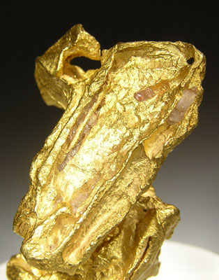
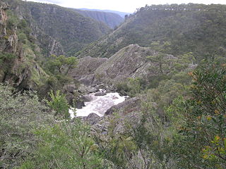
Hillgrove is a Northern Tablelands village with population of about 95. The village is located approximately 30 km east of Armidale and is 5 kilometres south of the Waterfall Way. Hillgrove is part of the Armidale Regional Council local government area and is in Sandon County. This historic goldmining town is situated at elevation of 1,000 metres on a granite plateau above Bakers Creek and near the Oxley Wild Rivers National Park.

Kangaroo Flat is a suburb of the Greater City of Bendigo in Victoria, Australia. It is located 5 kilometres South-West of the Bendigo CBD. Kangaroo Flat is neighbours with Golden Square, Big Hill, Lockwood, Maiden Gully and Mandurang. Kangaroo Flat derived its name from the large "mobs" (groups) of Eastern Grey Kangaroos encountered around gold miners' campsites and in the vast bush (forest) landscapes around Bendigo.

Warrandyte State Park is a state park, located in Warrandyte, east of Melbourne, Victoria on the banks of the Yarra River and surroundings. The park comprises 586 hectares of remnant bushland in various locations throughout Warrandyte and Wonga Park around Pound Bend, Fourth Hill, Black Flat, Yarra Brae and various other locations in the area. It hosts many significant geographical, environmental, archaeological and historical sites, such as the site of the first gold discovery in Victoria in 1851 and preserves the sites of former gold mines and tunnels. It is a popular destination for school and community groups and is frequented by local bush walkers and hikers.

Lal Lal is a town in Victoria (Australia), Australia. The town is located in the Shire of Moorabool and on the Geelong-Ballarat railway line, 108 kilometres (67 mi) west of the state capital, Melbourne. At the 2016 census, Lal Lal and the surrounding area had a population of 476.
Montacute is a small regional area in the Adelaide Hills, South Australia. Montacute is located on Fifth Creek, and the mostly-rural suburb extends from Rostrevor in the west to Lenswood in the east, bounded on the north by Castambul and on the south by Norton Summit and Cherryville. The small town of Montacute Heights is located on top of the ridge between Fifth and Sixth Creeks.

The Jordan River, a perennial river of the West Gippsland catchment, is located in the Alpine region of the Australian state of Victoria.