Catawissa Township, Columbia County, Pennsylvania

Last updated
Catawissa Township, Pennsylvania
Northwestern edge of Catawissa Mountain.JPG
Catawissa Mountain in Catawissa Township
Map of Catawissa Township, Columbia County, Pennsylvania Highlighted.png
Map of Columbia County, Pennsylvania highlighting Catawissa Township
Map of Pennsylvania highlighting Columbia County.svg
Map of Columbia County, Pennsylvania
Country United States
State Pennsylvania
County Columbia
Settled1774
Incorporated1785
Area
[1]
  Total12.88 sq mi (33.36 km2)
  Land12.36 sq mi (32.02 km2)
  Water0.52 sq mi (1.34 km2)
Population
 (2020) [2]
  Total904 Decrease2.svg
  Estimate 
(2021) [2]
908
  Density77.25/sq mi (29.83/km2)
Time zone UTC-5 (Eastern (EST))
  Summer (DST) UTC-4 (EDT)
Area code 570
FIPS code 42-037-11744

Catawissa Township is a township near the borough of Catawissa, Columbia County, Pennsylvania. It is part of Northeastern Pennsylvania. The population was 904 at the 2020 census. [2]

Contents

History

Catawissa Township is the oldest municipality in Columbia County. It was first formed in 1785 from parts of Augusta Township. When first formed, Catawissa Township stretched from Montour County in the west to western Schuylkill County in the east. The creations of Roaring Creek Township, Franklin Township, and Main Township in 1832, 1843, and 1844 respectively, reduced the size of Catawissa Township significantly. [3]

The first Native Americans to settle in the vicinity of the township were the Piscatawese, Conoys, or Gangawese, who built a wigwam in Catawissa. The first house in Catawissa Township was built in 1774 by Moses Roberts. By the mid to late 1770s, Quakers had arrived in the township. More settlers arrived in Catawissa Township in 1782. The same year, a group of Native Americans arrived in the area to re-establish a wigwam. This led to strife between them and the settlers, and several murders occurred. [3]

In 1833, there were two furnaces and two forges within the boundaries of Catawissa Township as it was at that time. [4]

The Hollingshead Covered Bridge No. 40 was listed on the National Register of Historic Places in 1979. [5]

Geography

Scenery of Catawissa Township Hill in Catawissa Township.JPG
Scenery of Catawissa Township

Catawissa Township is located southwest of the center of Columbia County, across the Susquehanna River from Bloomsburg, the county seat. The township is bordered to the north and northwest by the Susquehanna, to the west by the borough of Catawissa, to the southwest by Franklin Township, to the south by Cleveland and Locust townships, and to the east by Main Township. Catawissa Mountain, elevation 1,817 feet (554 m), occupies the southeastern part of the township.

According to the United States Census Bureau, the township has a total area of 12.9 square miles (33.4 km2), of which 12.4 square miles (32.0 km2) is land and 0.50 square miles (1.3 km2), or 4.01%, is water. [6] Catawissa Creek flows east to west across the center of the township, entering Catawissa borough before emptying into the Susquehanna River.

Geology

Iron ore is abundant in Catawissa Township. The soil in the township consists of clay and gravel. The terrain in the township is predominantly hilly. [4]

Demographics

Historical population
CensusPop.
2010 932
2020 904−3.0%
2021 (est.)908 [2] 0.4%
U.S. Decennial Census [7]

As of the census [8] of 2000, there were 944 people, 378 households, and 297 families residing in the township. The population density was 75.8 people per square mile (29.3/km2). There were 402 housing units at an average density of 32.3/sq mi (12.5/km2). The racial makeup of the township was 99.47% White, 0.42% African American, and 0.11% from two or more races.

There were 378 households, out of which 28.3% had children under the age of 18 living with them, 68.0% were married couples living together, 6.6% had a female householder with no husband present, and 21.4% were non-families. 19.0% of all households were made up of individuals, and 8.2% had someone living alone who was 65 years of age or older. The average household size was 2.50 and the average family size was 2.83.

In the township the population was spread out, with 21.2% under the age of 18, 3.6% from 18 to 24, 28.2% from 25 to 44, 31.3% from 45 to 64, and 15.8% who were 65 years of age or older. The median age was 43 years. For every 100 females, there were 100.9 males. For every 100 females age 18 and over, there were 98.9 males.

The median income for a household in the township was $44,250, and the median income for a family was $49,375. Males had a median income of $32,328 versus $26,579 for females. The per capita income for the township was $23,635. About 1.1% of families and 2.8% of the population were below the poverty line, including 2.0% of those under age 18 and 3.7% of those age 65 or over.

Related Research Articles

<span class="mw-page-title-main">Columbia County, Pennsylvania</span> County in Pennsylvania, United States

Columbia County is a county in the Commonwealth of Pennsylvania. It is located in Northeastern Pennsylvania. As of the 2020 census, the population was 64,727. Its county seat is Bloomsburg. The county was created on March 22, 1813, from part of Northumberland County. It was named Columbia, alluding to the United States and Christopher Columbus.

<span class="mw-page-title-main">Beaver Township, Columbia County, Pennsylvania</span> Township in Pennsylvania, United States

Beaver Township is a township in Columbia County, Pennsylvania. It is part of Northeastern Pennsylvania. The population was 879 at the 2020 census. Beaver Township is named for Beaver Run, a tributary of Catawissa Creek, both of which run through the township.

<span class="mw-page-title-main">Bloomsburg, Pennsylvania</span> Town in Pennsylvania, United States

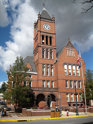
Bloomsburg is a town and the county seat of Columbia County, Pennsylvania. It is part of Northeastern Pennsylvania and is located 40 miles (64 km) southwest of Wilkes-Barre along the Susquehanna River. It is the only Pennsylvania municipality incorporated as a town. As of the 2010 census, Bloomsburg had a population of 14,855, with an estimated population of 13,811 in 2019.

<span class="mw-page-title-main">Catawissa, Pennsylvania</span> Borough in Pennsylvania, United States

Catawissa is a borough in Columbia County, Pennsylvania. It is part of Northeastern Pennsylvania. The population was 1,539 at the 2020 census. It is part of the Bloomsburg–Berwick Metropolitan Statistical Area.

Foundryville is a census-designated place (CDP) in Columbia County, Pennsylvania. It is part of Northeastern Pennsylvania. The population was 256 at the 2010 census. It is part of the Bloomsburg–Berwick Micropolitan Statistical Area.

<span class="mw-page-title-main">Franklin Township, Columbia County, Pennsylvania</span> Township in Pennsylvania, United States

Franklin Township is a township in Columbia County, Pennsylvania. It is part of Northeastern Pennsylvania. The population was 552 at the 2020 census.

<span class="mw-page-title-main">Hemlock Township, Columbia County, Pennsylvania</span> Township in Pennsylvania, United States

Hemlock Township is a township in Columbia County, Pennsylvania. It is part of Northeastern Pennsylvania. As of the 2020 census the population was 2,218, a decline from the figure of 2,249 tabulated in 2010.

<span class="mw-page-title-main">Jackson Township, Columbia County, Pennsylvania</span> Township in Pennsylvania, United States

Jackson Township is a township in Columbia County, Pennsylvania. It is part of Northeastern Pennsylvania. The population was 624 at the 2020 census.

<span class="mw-page-title-main">Main Township, Columbia County, Pennsylvania</span> Township in Pennsylvania, United States

Main Township is a township in Columbia County, Pennsylvania. It is part of Northeastern Pennsylvania. The population was 1,272 at the 2020 census. Main Township was settled in 1772 and incorporated in 1844. The iron industry was once preeminent in the township.

<span class="mw-page-title-main">Mainville, Pennsylvania</span> Census-designated place in Pennsylvania, United States

Mainville is a census-designated place in Columbia County, Pennsylvania. It is part of Northeastern Pennsylvania. The population was 132 at the 2010 census. It is part of the Bloomsburg–Berwick Micropolitan Statistical Area.

<span class="mw-page-title-main">Mifflin Township, Columbia County, Pennsylvania</span> Township in Pennsylvania, United States

Mifflin Township is a township in Columbia County, Pennsylvania. It is part of Northeastern Pennsylvania. The population was 2,277 at the 2020 census.

<span class="mw-page-title-main">Montour Township, Columbia County, Pennsylvania</span> Township in Pennsylvania, United States

Montour Township is a township in Columbia County, Pennsylvania. It is part of Northeastern Pennsylvania. The population was 1,263 at the 2020 census.

<span class="mw-page-title-main">Roaring Creek Township, Columbia County, Pennsylvania</span> Township in Pennsylvania, United States

Roaring Creek Township is a township in Columbia County, Pennsylvania. It is part of Northeastern Pennsylvania. The population was 545 at the 2010 census. The township office is located at 666 Bear Gap Road, Elysburg, Pennsylvania, outside the township.

<span class="mw-page-title-main">Rupert, Pennsylvania</span> Census-designated place in Pennsylvania, United States

Rupert is a census-designated place (CDP) in Columbia County, Pennsylvania. It is part of Northeastern Pennsylvania. The population was 183 at the 2010 census. It is part of the Bloomsburg–Berwick Micropolitan Statistical Area.

<span class="mw-page-title-main">Scott Township, Columbia County, Pennsylvania</span> Township in Pennsylvania, United States

Scott Township is a township in Columbia County, Pennsylvania. It is part of Northeastern Pennsylvania. The population was 5,527 at the 2020 census, an increase over the figure of 5,113 tabulated in 2000.

<span class="mw-page-title-main">Dallas, Pennsylvania</span> Borough in Pennsylvania, United States

Dallas is a borough in Luzerne County, Pennsylvania, United States. The population was 2,692 at the 2020 census. The local government describes the borough as the "Pride" of the Back Mountain. The area includes the townships of Dallas, Franklin, Jackson, Kingston, Lake, and Lehman. The region also includes the boroughs of Dallas and Harveys Lake. Dallas is in the vicinity of Misericordia University and Dallas State Correctional Institution.

<span class="mw-page-title-main">Franklin Township, Lycoming County, Pennsylvania</span> Township in Pennsylvania, United States

Franklin Township is a township in Lycoming County, Pennsylvania, United States. The population was 901 at the 2020 census. It is part of the Williamsport Metropolitan Statistical Area.

<span class="mw-page-title-main">Cooper Township, Montour County, Pennsylvania</span> Township in Pennsylvania, United States

Cooper Township is a township in Montour County, Pennsylvania, United States.

<span class="mw-page-title-main">Danville, Pennsylvania</span> Borough in Pennsylvania, United States

Danville is a borough in and the county seat of Montour County, Pennsylvania, United States, along the North Branch of the Susquehanna River. The population was 4,221 at the census.

<span class="mw-page-title-main">Mahoning Township, Montour County, Pennsylvania</span> Township in Pennsylvania, United States

Mahoning Township is a township in Montour County, Pennsylvania, United States.

References

  1. "2016 U.S. Gazetteer Files". United States Census Bureau. Retrieved Aug 13, 2017.
  2. 1 2 3 4 Bureau, US Census. "City and Town Population Totals: 2020—2021". Census.gov. US Census Bureau. Retrieved July 27, 2022.
  3. 1 2 "Chapter XVI, Catawissa and Franklin Townships, History of Columbia and Montour Counties, Pennsylvania". www.pa-roots.com. Retrieved 2016-05-21.
  4. 1 2 Gordon, Thomas Francis (1833-01-01). A gazetteer of the state of Pennsylvania. T. Belknap.
  5. "National Register Information System". National Register of Historic Places . National Park Service. July 9, 2010.
  6. "Geographic Identifiers: 2010 Census Summary File 1 (G001): Catawissa township, Columbia County, Pennsylvania". U.S. Census Bureau, American Factfinder. Archived from the original on February 13, 2020. Retrieved May 20, 2015.
  7. "Census of Population and Housing". Census.gov. Retrieved June 4, 2016.
  8. "U.S. Census website". United States Census Bureau . Retrieved 2008-01-31.

Coordinates: 40°58′00″N76°25′59″W / 40.96667°N 76.43306°W / 40.96667; -76.43306