
The State of Mexico, officially just Mexico, is one of the 32 federal entities of the United Mexican States. Commonly known as Edomex to distinguish it from the name of the whole country, it is the most populous, as well as the most densely populated, state in the country.

Malinalco is the municipality inside of Ixtapan Region, is a town and municipality located 65 kilometers south of the city of Toluca in the south of the western portion of the State of Mexico. Malinalco is 115 km (71 mi) southwest of Mexico City.
Coatlán del Río is a town in the Mexican state of Morelos. It stands at 18°45′N99°26′W, at a mean height of 1,010 metres above sea level.
Mazatepec is a city in the Mexican state of Morelos..

Puente de Ixtla is a city in the Mexican state of Morelos. It stands at 18°37′01″N99°19′23″W. The city serves as the municipal seat for the surrounding municipality of the same name. The municipality reported 66,435 inhabitants in the year 2015 census.
Platón Sánchez is a municipality in the Mexican state of Veracruz. It is located in the state's Huasteca Alta region. The municipal seat is the town of Platón Sánchez.

Otatitlán is a town and municipality in the Mexican state of Veracruz, in the south of the state along the border with the state of Oaxaca. The town is best known for its large black image of a crucified Christ, one of three notable images of this type. Most of the population in Otatitlán is poor and the area is dedicated to agriculture, especially sugar cane and bananas.

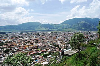
Santiago Tianguistenco, often simply called Santiago by locals, is a city located in Mexico State about thirty km south of the state capital of Toluca. It is the municipal seat for the municipality of Tianguistenco. It is located in the southwest part of the Valley of Toluca at the edge of the Ajusco mountain range that separates it from Mexico City. The name Tianguistenco (Tyanguistengko) is from Nahuatl and means “at the edge of the tianguis,” which is a traditional Aztec market. The section of the city where the industrial park is still bears this name. Historically, the area was known as having one of the richest and best-stocked markets in the Toluca Valley. Today, it is still home to a large permanent municipal market as well as a weekly tianguis that covers much of the historic center.
The municipality of Tenango del Valle is located in the southern portion of the Valley of Toluca in Mexico State, about 72 km southwest of Mexico City and 25 km south of Toluca. The municipal seat is the city of Tenango de Arista. While the seat is officially named Tenango de Arista, it is more commonly referred to as Tenango del Valle, as this was the original name of the town. Tenango del Valle is best known as the site of the Teotenango archeological site, which was a walled city inhabited from about 900 C.E. to 1550 C.E.

Tequixquiac is a municipality located in the Zumpango Region of the State of Mexico in Mexico. The municipality is located 84 kilometres (52 mi) north of Mexico City within the valley that connects the Valley of Mexico with the Mezquital Valley. The name comes from Nahuatl and means "place of tequesquite waters". The municipal seat is the town of Santiago Tequixquiac, although both the town and municipality are commonly referred to as simply "Tequixquiac".
Chalma is a municipality in the Mexican state of Veracruz.
Chiconamel is a municipality in the Mexican state of Veracruz. It is located in the state's Huasteca Alta region. The municipal seat is the village of Chiconamel, Veracruz.
El Higo is a municipality of the Mexican state of Veracruz. It is located in the state's Huasteca Alta region. The municipal seat is the village of El Higo, Veracruz.
Ayapango is one of 125 municipalities located in the southeast portion of the State of Mexico, southeast of Mexico City. It's municipal seat and largest town is Ayapango de Gabriel Ramos Millán. Despite the fact that this municipality is distinctly rural, it falls within the Mexico City Metropolitan Area. The town is known for its "French style" houses built early in the last century which have names which reflect something of their characteristics. The name Ayapango is derived from "eyapanco" which roughly translates to "place where three irrigation ditches meet." This town has been designated as a "Pueblo con Encanto" by the government of the State of Mexico.

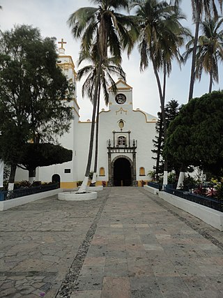
Chalma is a small community, which is part of the municipality of Malinalco, Mexico State. Its small population is almost completely dedicated to the pilgrims who come to visit the Sanctuary of Chalma, the second most-important pilgrimage site in Mexico. The sanctuary is dedicated to an image of what many people describe as a "black Christ" on a cross that legend says miraculously appeared in an area cave where the worship of a deity commonly known as Oxtoteotl used to take place. Some contend that as Oxtoteotl is an aspect of Tezcatlipoca, the "Smoking Mirror," then the "black Christ" is really Tezcatlipoca, which the Spanish friars superimposed on the existing representation of Tezcatlipoca in order to convert the natives. Pilgrimages to this Christian sanctuary follow many of the patterns of the prehispanic rituals, including walking the narrow paths to the town itself, bathing in the waters of a special fresh-water spring and dancing at the sanctuary.

Fernando Leal was one of the first painters to participate in the Mexican muralism movement starting in the 1920s. After seeing one of his paintings, Secretary of Education José Vasconcelos invited Leal to paint at the Escuela Nacional Preparatoria. The resulting work is Los danzantes de Chalma. Leal also painted a mural dedicated to Simón Bolívar at the Anfiteatro Bolivar, as well as religious murals such as those at the chapel dedicated to the Virgin of Guadalupe at the Basilica Villa in Tepeyac.
The Cristos Negros or Black Christs of Central America and Mexico trace their origins to the veneration of an image of Christ on a cross located in the Guatemalan town of Esquipulas, near the Honduran and Salvadoran border. This image was sculpted in 1595 in wood and over time it blackened and gained a reputation for being miraculous. Little is known of how veneration of the image was spread by clergy, although there are records of its introduction in various locations, especially in Central America, southern Mexico, central Mexico and even as far north as New Mexico. However, a number of these images, such as the ones in Chalma, State of Mexico and Mérida, Yucatán have origin stories that do not connect the local image with that of Esquipulas. The Cristo Negro of Esquipulas remains an important symbol for Central America, with its sanctuary the most visited site in the region. On January 11, 2021, a replica of Christ of Esquipulas and his accompanying statues were donated to Saint Joseph Cathedral of Antigua Guatemala eliciting an uncontainable and renewed veneration for Black Christ of Esquipulas among his followers. There are hundreds of other such images with at least local importance with Christ of Chalma attracting millions of visitors, second only to that of the Virgin of Guadalupe in Mexico. The popularity of the image continues to spread, with Central American and Mexican migrants bringing the image to the United States and Canada, founding new sanctuaries.
XHRHV-FM is a noncommercial radio station on 89.1 FM in Chalma, Veracruz, known as Macro Radio.

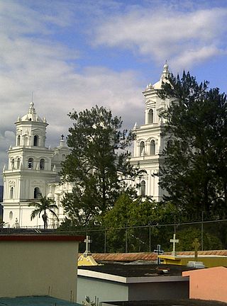
The Lord of the Chapel,, is a statue of the crucifixion of Jesus from Saint James Apostle parish in Santiago Tequixquiac, Mexico. The image is popularly believed to have placated any further disaster caused by illness and epidemics with Indigenous people. It became the patron saint of Santiago Tequixquiac, and is one of the most well-known images in Mexico State. It was probably created in Actopan ex-monastery by native artists around 1570, and is made of mixed materials, including sticks, plaques of agave fiber, and plaster. The author is unknown and belongs to the Spanish colonial period.
On 26 November 2021, a bus crashed on the Joquicingo-Malinalco highway in Central Mexico, killing at least 19 people. A bus carrying Catholic pilgrims was travelling on a highway on route to a religious shrine when it crashed into a house.

