Chandlers Valley, Pennsylvania

Last updated

Chandlers Valley, Pennsylvania
Unincorporated community
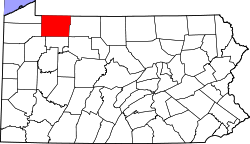
USA Pennsylvania location map.svg
Red pog.svg
Chandlers Valley
Coordinates: 41°56′03″N79°18′13″W / 41.93417°N 79.30361°W / 41.93417; -79.30361
Country United States
State Pennsylvania
County Warren
Elevation
1,506 ft (459 m)
Time zone UTC-5 (Eastern (EST))
  Summer (DST) UTC-4 (EDT)
ZIP code
16312
Area code 814
GNIS feature ID1171556 [1]

Chandlers Valley is an unincorporated community in Warren County, Pennsylvania, United States. [1] Chandlers Valley has a post office with ZIP code 16312. [2] [3]

Contents

Climate

Climate data for CHANDLERS VALLEY 1SE, PA (1991-2020 normals) (Records 2004-Present)
MonthJanFebMarAprMayJunJulAugSepOctNovDecYear
Record high °F (°C)65
(18)
73
(23)
80
(27)
85
(29)
91
(33)
93
(34)
98
(37)
91
(33)
92
(33)
85
(29)
76
(24)
65
(18)
98
(37)
Mean daily maximum °F (°C)30.7
(−0.7)
33.5
(0.8)
42.7
(5.9)
56.7
(13.7)
68.4
(20.2)
76.9
(24.9)
80.4
(26.9)
78.7
(25.9)
72.6
(22.6)
59.6
(15.3)
46.5
(8.1)
35.6
(2.0)
56.9
(13.8)
Daily mean °F (°C)22.0
(−5.6)
22.9
(−5.1)
31.3
(−0.4)
43.3
(6.3)
54.2
(12.3)
63.0
(17.2)
66.8
(19.3)
65.4
(18.6)
59.1
(15.1)
47.8
(8.8)
37.1
(2.8)
27.9
(−2.3)
45.1
(7.3)
Mean daily minimum °F (°C)13.2
(−10.4)
12.3
(−10.9)
19.9
(−6.7)
29.9
(−1.2)
40.1
(4.5)
49.2
(9.6)
53.2
(11.8)
52.2
(11.2)
45.6
(7.6)
36.0
(2.2)
27.6
(−2.4)
20.2
(−6.6)
33.3
(0.7)
Record low °F (°C)−21
(−29)
−32
(−36)
−25
(−32)
8
(−13)
22
(−6)
30
(−1)
37
(3)
38
(3)
27
(−3)
19
(−7)
2
(−17)
−14
(−26)
−32
(−36)
Average precipitation inches (mm)3.73
(95)
2.47
(63)
3.36
(85)
4.17
(106)
4.39
(112)
4.61
(117)
5.52
(140)
4.09
(104)
4.22
(107)
4.33
(110)
3.97
(101)
4.01
(102)
48.87
(1,241)
Average snowfall inches (cm)31.4
(80)
26.5
(67)
12.7
(32)
6.7
(17)
0.1
(0.25)
0.0
(0.0)
0.0
(0.0)
0.0
(0.0)
0.0
(0.0)
0.6
(1.5)
9.7
(25)
28.0
(71)
115.7
(294)
Average precipitation days (≥ 0.01 in)21.217.315.516.314.414.213.112.611.316.515.519.4187.3
Average snowy days (≥ 0.1 in)13.411.76.32.80.10.00.00.00.00.43.910.248.8
Source: NOAA [4]

Notable people

Notes

  1. 1 2 "Chandlers Valley, Pennsylvania". Geographic Names Information System . United States Geological Survey, United States Department of the Interior.
  2. United States Postal Service. "USPS - Look Up a ZIP Code" . Retrieved June 28, 2017.
  3. "Postmaster Finder - Post Offices by ZIP Code". United States Postal Service. Archived from the original on October 17, 2020. Retrieved June 28, 2017.
  4. "Monthly Normals 1991-2020". National Oceanic and Atmospheric Administration . Retrieved November 3, 2022.
  5. Wingard, Joel (1996). "Appendix: Lives of the Writers". Literature: Reading and Responding to Fiction, Poetry, Drama, and the Essay (1st ed.). New York: HarperCollins College Publishers. p. 1666. ISBN   0-06-501735-8.
  6. Whitermore, Carolyn (October 14, 1991). Interview with Robert Buck of 10,000 Maniacs (video). Rob Buck of 10,000 Maniacs. Jamestown TV Profiles. Event occurs at 0:44 via YouTube.
  7. 'Wisconsin Blue Book 1905,' Biographical Sketch of Lafayette M. Sturdevant, pg. 1071

Further reading

Related Research Articles

<span class="mw-page-title-main">ZIP Code</span> Numeric postal code used in the United States and its territories

A ZIP Code is a system of postal codes used by the United States Postal Service (USPS). Introduced on July 1, 1963, the basic format consisted of five digits. In 1983, an extended ZIP+4 code was introduced; it included the five digits of the ZIP Code, followed by a hyphen and four digits that designated a more specific location.

<span class="mw-page-title-main">Heafford Junction, Wisconsin</span> Unincorporated community in Wisconsin, United States

Heafford Junction is an unincorporated community located in Lincoln County, Wisconsin, United States. Heafford Junction is located along U.S. Route 8 north of Tomahawk, in the town of Bradley, and is surrounded by several lakes. Heafford Junction was named for George Heafford, an employee of the Chicago, Milwaukee & St. Paul Railroad. The community had a post office, which was opened by its first postmaster, Warren Slater, in March 1898. It closed on November 30, 1984.

Lafayette Monroe Sturdevant was a Wisconsin lawyer and politician.

<span class="mw-page-title-main">Coulter, Pennsylvania</span> Census-designated place in Pennsylvania, United States

Coulter is an unincorporated community and census-designated place in South Versailles Township, Allegheny County, Pennsylvania, United States. The community is located along the Youghiogheny River, 14.3 miles (23.0 km) southeast of Pittsburgh.

Concord is an unincorporated community in Fannett Township, Franklin County, Pennsylvania, United States. The community is located on Pennsylvania Route 75, 9.6 miles (15.4 km) south-southwest of East Waterford. Concord has a post office, with ZIP code 17217.

Brush Valley is an unincorporated community in Indiana County, Pennsylvania, United States. The community is located at the intersection of Pennsylvania Route 56 and Pennsylvania Route 259, 7.4 miles (11.9 km) southeast of Indiana. Brush Valley was founded by John Cresswell in 1803. The town was originally named Mechanicsburgh. It has its own ZIP code, 15720.

Listie is an unincorporated community in Somerset County, Pennsylvania, United States. The community is located 3.7 miles (6.0 km) east-northeast of Somerset. Listie had a post office until September 28, 2002; it still has its own ZIP code, 15549.

Hibbs is an unincorporated community in Fayette County, Pennsylvania, United States. The community is located along Pennsylvania Route 166, 5.9 miles (9.5 km) north of Masontown. Hibbs has a post office with ZIP code 15443.

Indian Head is an unincorporated community in Fayette County, Pennsylvania, United States. The community is located along Pennsylvania Route 381, 10.4 miles (16.7 km) east of Connellsville. Indian Head has a post office with ZIP code 15446, which opened on December 17, 1853. The community was named for its location near the headwaters of Indian Creek.

Keisterville is an unincorporated community in Fayette County, Pennsylvania, United States. The community is located near Pennsylvania Route 43, 5.5 miles (8.9 km) northwest of Uniontown. Keisterville has a post office with ZIP code 15449.

Alverton is an unincorporated community in Westmoreland County, Pennsylvania, United States. The community is located along Pennsylvania Route 981, 2.5 miles (4.0 km) west of Mount Pleasant. Alverton has a post office, with ZIP code 15612.

Branchton is an unincorporated community in Butler County, Pennsylvania, United States. The community is located near Pennsylvania Route 8, 3.7 miles (6.0 km) east of Slippery Rock. Branchton had a post office until April 23, 2005; it still has its own ZIP code, 16021.

Irvine is an unincorporated community in Warren County, Pennsylvania, United States. The community is located near the junction of U.S. Route 6 and U.S. Route 62, 6.4 miles (10.3 km) west of Warren. Irvine has a post office with ZIP code 16329.

Garland is an unincorporated community in Warren County, Pennsylvania, United States. The community is on Pennsylvania Route 27, 6.9 miles (11.1 km) west-southwest of Youngsville. Garland has a post office with ZIP code 16416.

Beach Haven is an unincorporated community in Salem Township, Luzerne County, Pennsylvania, United States. The community is located along the Susquehanna River and U.S. Route 11; it is 3.1 miles (5.0 km) east of Berwick. Beach Haven has a post office with ZIP code 18601, which opened on February 6, 1844.

Hunlock Creek is an unincorporated community in Hunlock Township, Luzerne County, Pennsylvania, United States. The community is located along the Susquehanna River and U.S. Route 11, 3.2 miles (5.1 km) west of Nanticoke. Hunlock Creek has a post office with ZIP code 18621. In 1940, a regional guidebook noted that the town, "its shacks resting in a mountain cleft, is named for the coal-blackened stream that splits it into a number of sections. US 11 parallels the winding river through a long valley that broadens out occasionally to include a cultivated tract on the river flat."

Warren Center is an unincorporated community in Bradford County, Pennsylvania, United States. The community is 4.5 miles (7.2 km) southwest of Little Meadows. Warren Center has a post office with ZIP code 18851.

Wysox is an unincorporated community in Bradford County, Pennsylvania, United States. The community is located at the intersection of U.S. Route 6 and Pennsylvania Route 187, 2.3 miles (3.7 km) east of Towanda. Wysox has a post office with ZIP code 18854.

<span class="mw-page-title-main">Pond Eddy, New York</span> Hamlet in New York, United States

Pond Eddy is a hamlet in Sullivan County, New York, United States. The community is located along the Delaware River and New York State Route 97. The Pond Eddy Bridge links the hamlet to the community of Pond Eddy, Pennsylvania, which is only accessible via the bridge. Pond Eddy has a post office with ZIP code 12770.

Kill Buck is a hamlet in Cattaraugus County, New York, United States. The community is located along New York State Route 417 and U.S. Route 219 Business, sharing its western border with the eastern border of the city of Salamanca. Kill Buck is named after Daniel Kill Buck, who was a mayor of the community during its days as a Seneca village.