Cleveland, North Dakota

Last updated

Cleveland, North Dakota
City Hall Cleveland, North Dakota 6-10-2008.jpg
City Hall in Cleveland
ND Stutsman County Cleveland.svg
Location of Cleveland, North Dakota
Coordinates: 46°53′27″N99°07′10″W / 46.89083°N 99.11944°W / 46.89083; -99.11944
CountryUnited States
State North Dakota
County Stutsman
Founded1882
Area
[1]
  Total0.21 sq mi (0.55 km2)
  Land0.21 sq mi (0.55 km2)
  Water0.00 sq mi (0.00 km2)
Elevation
[2]
1,873 ft (571 m)
Population
 (2020) [3]
  Total57
  Estimate 
(2022) [4]
60
  Density268.87/sq mi (103.95/km2)
Time zone UTC-6 (Central (CST))
  Summer (DST) UTC-5 (CDT)
ZIP code
58424
Area code 701
FIPS code 38-14660
GNIS feature ID1035971 [2]

Cleveland is a city in Stutsman County, North Dakota, United States. The population was 57 at the 2020 census. [3]

Contents

History

Cleveland was founded in 1882. It was named for Cleveland, Ohio. [5] A post office has been in operation at Cleveland since 1882. [6]

Geography

According to the United States Census Bureau, the city has a total area of 0.18 square miles (0.47 km2), all land. [7]

Demographics

Historical population
CensusPop.Note
1920 341
1930 273−19.9%
1940 246−9.9%
1950 181−26.4%
1960 169−6.6%
1970 128−24.3%
1980 1301.6%
1990 121−6.9%
2000 112−7.4%
2010 83−25.9%
2020 57−31.3%
2022 (est.)60 [4] 5.3%
U.S. Decennial Census [8]
2020 Census [3]

2010 census

As of the census of 2010, there were 83 people in 40 households, including 21 families, in the city. The population density was 461.1 inhabitants per square mile (178.0/km2). There were 54 housing units at an average density of 300.0 per square mile (115.8/km2). The racial makup of the city was 100.0% White.

Of the 40 households 20.0% had children under the age of 18 living with them, 47.5% were married couples living together, 5.0% had a male householder with no wife present, and 47.5% were non-families. 42.5% of households were one person and 15% were one person aged 65 or older. The average household size was 2.08 and the average family size was 2.90.

The median age was 44.5 years. 21.7% of residents were under the age of 18; 2.3% were between the ages of 18 and 24; 26.4% were from 25 to 44; 27.6% were from 45 to 64; and 21.7% were 65 or older. The gender makeup of the city was 56.6% male and 43.4% female.

2000 census

As of the census of 2000, there were 112 people in 52 households, including 34 families, in the city. The population density was 617.5 inhabitants per square mile (238.4/km2). There were 59 housing units at an average density of 325.3 per square mile (125.6/km2). The racial makup of the city was 99.11% White and 0.89% Native American.

Of the 52 households 26.9% had children under the age of 18 living with them, 50.0% were married couples living together, 7.7% had a female householder with no husband present, and 34.6% were non-families. 34.6% of households were one person and 13.5% were one person aged 65 or older. The average household size was 2.15 and the average family size was 2.68.

The age distribution was 25.9% under the age of 18, 4.5% from 18 to 24, 20.5% from 25 to 44, 32.1% from 45 to 64, and 17.0% 65 or older. The median age was 42 years. For every 100 females, there were 100.0 males. For every 100 females age 18 and over, there were 97.6 males.

The median household income was $25,179 and the median family income was $26,750. Males had a median income of $27,500 versus $26,875 for females. The per capita income for the city was $13,707. There were 14.3% of families and 15.8% of the population living below the poverty line, including 12.0% of under eighteens and 9.5% of those over 64.

Related Research Articles

<span class="mw-page-title-main">Oldtown, Idaho</span> City in Idaho, United States

Oldtown is a city in Bonner County, Idaho and suburb of Newport, Washington, with a population of 184 at the 2010 census. It is located on the Pend Oreille River, just east of Newport. There are no natural or physical barriers, and it is strictly a political division, separated by the straight-line state boundary. Oldtown is squeezed between this boundary to the west and the river to the east, leaving the main business district on U.S. Route 2 with only 700 feet of space in which to operate on the Idaho side. Many homes are located in the south end on the other side of the railroad, as the Pend Oreille is somewhat further away here.

<span class="mw-page-title-main">Wilder, Idaho</span> City in Idaho, United States

Wilder is a city in Canyon County, Idaho, United States. The population was 1,533 at the 2010 census.

<span class="mw-page-title-main">Culdesac, Idaho</span> City in Idaho, United States

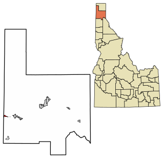
Culdesac is a city in Nez Perce County, Idaho, United States. The population was 380 at the 2010 census. It is part of the Lewiston, ID-WA Metropolitan Statistical Area.

<span class="mw-page-title-main">Nodaway, Iowa</span> City in Iowa, United States

Nodaway is a city in Nodaway Township, Adams County, Iowa, United States. The population was 74 at the time of the 2020 census. Nodaway was incorporated in 1900.

<span class="mw-page-title-main">Shellsburg, Iowa</span> City in Iowa, United States

Shellsburg is a city in Benton County, Iowa, United States. The population was 961 at the time of the 2020 census. It is part of the Cedar Rapids Metropolitan Statistical Area.

<span class="mw-page-title-main">Rinard, Iowa</span> City in Iowa, United States

Rinard is a city in Calhoun County, Iowa, United States. The population was 38 at the time of the 2020 census.

<span class="mw-page-title-main">Van Wert, Iowa</span> City in Iowa, United States

Van Wert is a city in northern Decatur County, Iowa, United States. The population was 178 at the time of the 2020 census.

<span class="mw-page-title-main">Wyoming, Iowa</span> City in Iowa, United States

Wyoming is a city in Jones County, Iowa, United States. The population was 523 at the time of the 2020 census. It is part of the Cedar Rapids Metropolitan Statistical Area.

<span class="mw-page-title-main">Macksburg, Iowa</span> City in Iowa, United States

Macksburg is a city in Madison County, Iowa, United States. The population was 97 at the time of the 2020 census. It is part of the Des Moines–West Des Moines Metropolitan Statistical Area.

<span class="mw-page-title-main">Ruthven, Iowa</span> City in Iowa, United States

Ruthven is a city in Palo Alto County, Iowa, United States. The population was 725 at the time of the 2020 census.

<span class="mw-page-title-main">Maloy, Iowa</span> City in Iowa, United States

Maloy is a city in southwest Ringgold County, Iowa, United States, along the Platte River. The population was 22 at the time of the 2020 census.

<span class="mw-page-title-main">Spring Hill, Iowa</span> City in Iowa, United States

Spring Hill is a city in Warren County, Iowa, United States. The population was 68 at the time of the 2020 census. It is part of the Des Moines–West Des Moines Metropolitan Statistical Area.

<span class="mw-page-title-main">St. Marys, Iowa</span> City in Iowa, United States

St. Marys or Saint Marys is a city in Warren County, Iowa, United States. The population was 108 at the time of the 2020 census.

<span class="mw-page-title-main">Crawfordsville, Iowa</span> City in Iowa, United States

Crawfordsville is a city in Washington County, Iowa, United States. It is part of the Iowa City, Iowa Metropolitan Statistical Area. The population was 277 at the 2020 census.

<span class="mw-page-title-main">West Chester, Iowa</span> City in Iowa, United States

West Chester is a city in Washington County, Iowa, United States. It is part of the Iowa City, Iowa Metropolitan Statistical Area. The population was 144 at the time of the 2020 census.

<span class="mw-page-title-main">Aldrich, Minnesota</span> City in Minnesota, United States

Aldrich is a city in Wadena County, Minnesota, United States, along the Partridge River. The population was 48 at the 2010 census. The small community holds the distinction as the first permanent settlement in Wadena County and the first to establish a post office. It is also home to the first Catholic church in the area, established in 1870, as a mission church.

<span class="mw-page-title-main">Mosby, Missouri</span> City in Missouri, United States

Mosby is a city in Clay County, Missouri, United States, along the Fishing River. The population was 101 at the 2020 census. It is part of the Kansas City metropolitan area.

<span class="mw-page-title-main">Dwight, North Dakota</span> City in North Dakota, United States

Dwight is a city in Richland County, North Dakota, United States. The population was 80 at the 2020 census. Dwight was founded in 1881. It is part of the Wahpeton, ND–MN Micropolitan Statistical Area.

<span class="mw-page-title-main">Bryant, South Dakota</span> City in South Dakota, United States

Bryant is a city in Hamlin County, South Dakota, United States. It is part of the Watertown, South Dakota Micropolitan Statistical Area. The population was 471 at the 2020 census.

<span class="mw-page-title-main">Whitewood, South Dakota</span> City in South Dakota, United States

Whitewood is a city in Lawrence County, South Dakota, United States. The population was 879 at the 2020 census.

References

  1. "ArcGIS REST Services Directory". United States Census Bureau. Retrieved September 20, 2022.
  2. 1 2 U.S. Geological Survey Geographic Names Information System: Cleveland, North Dakota
  3. 1 2 3 "Explore Census Data". United States Census Bureau . Retrieved December 14, 2023.
  4. 1 2 "City and Town Population Totals: 2020-2022". United States Census Bureau. December 14, 2023. Retrieved December 14, 2023.
  5. Federal Writers' Project (1938). North Dakota, a Guide to the Northern Prairie State. WPA. p. 285. ISBN   978-1-62376-033-5.
  6. "Stutsman County". Jim Forte Postal History. Retrieved October 22, 2015.
  7. "US Gazetteer files 2010". United States Census Bureau . Retrieved May 17, 2015.
  8. United States Census Bureau. "Census of Population and Housing" . Retrieved October 31, 2013.