Spiritwood Lake, North Dakota

Last updated

Spiritwood Lake
Sign in Spiritwood Lake, North Dakota 6-9-2008.jpg
Sign in Spiritwood Lake
ND Stutsman County Spiritwood Lake.svg
Location of Spiritwood Lake, North Dakota
Coordinates: 47°04′28″N98°35′12″W / 47.07444°N 98.58667°W / 47.07444; -98.58667
CountryUnited States
State North Dakota
County Stutsman
Founded1873
Incorporated October 1, 1935
Area
[1]
  Total1.86 sq mi (4.83 km2)
  Land1.14 sq mi (2.96 km2)
  Water0.72 sq mi (1.87 km2)
Elevation
[2]
1,434 ft (437 m)
Population
 (2020) [3]
  Total97
  Estimate 
(2022) [4]
92
  Density85.01/sq mi (32.82/km2)
Time zone UTC-6 (Central (CST))
  Summer (DST) UTC-5 (CDT)
ZIP code
58401
Area code 701
FIPS code 38-74740
GNIS feature ID1036282 [2]

Spiritwood Lake is a city in Stutsman County, North Dakota, United States. The population was 97 at the 2020 census. [3]

Contents

Geography

According to the United States Census Bureau, the city has a total area of 1.79 square miles (4.64 km2), of which 1.07 square miles (2.77 km2) is land and 0.72 square miles (1.86 km2) is water. [5]

Demographics

Historical population
CensusPop.Note
1880 50
1980 50
1990 6122.0%
2000 7218.0%
2010 9025.0%
2020 977.8%
2022 (est.)92 [4] −5.2%
U.S. Decennial Census [6]
2020 Census [3]

2010 census

As of the census of 2010, there were 90 people, 40 households, and 33 families residing in the city. The population density was 84.1 inhabitants per square mile (32.5/km2). There were 99 housing units at an average density of 92.5 per square mile (35.7/km2). The racial makeup of the city was 100.0% White.

There were 40 households, of which 20.0% had children under the age of 18 living with them, 77.5% were married couples living together, 5.0% had a female householder with no husband present, and 17.5% were non-families. 17.5% of all households were made up of individuals, and 10% had someone living alone who was 65 years of age or older. The average household size was 2.25 and the average family size was 2.48.

The median age in the city was 55.3 years. 12.2% of residents were under the age of 18; 4.4% were between the ages of 18 and 24; 17.7% were from 25 to 44; 37.7% were from 45 to 64; and 27.8% were 65 years of age or older. The gender makeup of the city was 50.0% male and 50.0% female.

2000 census

As of the census of 2000, there were 72 people, 31 households, and 23 families residing in the city. The population density was 66.5 inhabitants per square mile (25.7/km2). There were 63 housing units at an average density of 58.2 per square mile (22.5/km2). The racial makeup of the city was 100.00% White.

There were 31 households, out of which 25.8% had children under the age of 18 living with them, 74.2% were married couples living together, 3.2% had a female householder with no husband present, and 22.6% were non-families. 19.4% of all households were made up of individuals, and 6.5% had someone living alone who was 65 years of age or older. The average household size was 2.32 and the average family size was 2.67.

In the city, the population was spread out, with 19.4% under the age of 18, 1.4% from 18 to 24, 25.0% from 25 to 44, 37.5% from 45 to 64, and 16.7% who were 65 years of age or older. The median age was 47 years. For every 100 females, there were 125.0 males. For every 100 females age 18 and over, there were 114.8 males.

The median income for a household in the city was $43,500, and the median income for a family was $45,625. Males had a median income of $22,500 versus $14,375 for females. The per capita income for the city was $24,637. None of the population and none of the families were below the poverty line.

Related Research Articles

<span class="mw-page-title-main">Hazleton, Iowa</span> City in Iowa, United States

Hazleton is a city in Buchanan County, Iowa, United States. The population was 713 at the time of the 2020 census.

<span class="mw-page-title-main">Willey, Iowa</span> City in Iowa, United States

Willey is a city in Carroll County, Iowa, United States. The population was 73 at the time of the 2020 census.

<span class="mw-page-title-main">Delaware, Iowa</span> City in Iowa, United States

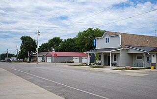
Delaware is a city in Delaware County, Iowa, United States. The population was 142 at the time of the 2020 census.

<span class="mw-page-title-main">Maynard, Iowa</span> City in Iowa, United States

Maynard is a city in Fayette County, Iowa, United States. The population was 476 at the time of the 2020 census.

<span class="mw-page-title-main">Lilydale, Minnesota</span> City in Minnesota, United States

Lilydale is a city in Dakota County, Minnesota, United States. The population was 623 at the 2010 census.

<span class="mw-page-title-main">Lastrup, Minnesota</span> City in Minnesota, United States

Lastrup is a city in Morrison County, Minnesota, United States. The population was 120 at the 2020 census.

<span class="mw-page-title-main">Clitherall, Minnesota</span> City in Minnesota, United States

Clitherall is a city in Otter Tail County, Minnesota, United States. The population was 62 at the 2020 census.

<span class="mw-page-title-main">Elizabeth, Minnesota</span> City in Minnesota, United States

Elizabeth is a city in Otter Tail County, Minnesota, United States. The population was 168 at the 2020 census.

<span class="mw-page-title-main">Richville, Minnesota</span> City in Minnesota, United States

Richville is a city in Otter Tail County, Minnesota, United States. The population was 77 as of the 2020 census.

<span class="mw-page-title-main">Lake Henry, Minnesota</span> City in Minnesota, United States

Lake Henry is a city in Stearns County, Minnesota, United States. The population was 103 at the 2010 census. It is part of the St. Cloud Metropolitan Statistical Area.

<span class="mw-page-title-main">Country Club Hills, Missouri</span> City in Missouri, United States

Country Club Hills is a city in St. Louis County, Missouri, United States. The population was 1,274 at the 2010 census.

<span class="mw-page-title-main">Flordell Hills, Missouri</span> City in Missouri, United States

Flordell Hills is a city in St. Louis County, Missouri, United States. The population was 822 at the 2010 census.

<span class="mw-page-title-main">Moline Acres, Missouri</span> City in Missouri, United States

Moline Acres is a city in St. Louis County, Missouri, United States. The population was 2,442 at the 2010 census.

<span class="mw-page-title-main">Warson Woods, Missouri</span> City in Missouri, United States

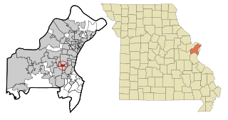
Warson Woods is a city in St. Louis County, Missouri, United States. The population was 1,962 at the 2010 census.

<span class="mw-page-title-main">Lincoln, North Dakota</span> City in North Dakota, United States

Lincoln is a city in Burleigh County, North Dakota, United States. It is a suburb of adjacent Bismarck, and also a core city of the Bismarck-Mandan Metropolitan Statistical Area. The population was 4,257 at the 2020 census, making it the 14th most populous city in North Dakota. Lincoln was founded in 1977.

<span class="mw-page-title-main">Frontier, North Dakota</span> City in North Dakota, United States

Frontier is a city in Cass County, North Dakota, United States. The population was 195 at the 2020 census. Frontier is located south of the city of Fargo and is located roughly six miles southwest of that city's downtown. Frontier was founded in 1976. Since Frontier's founding, the adjacent city of Fargo has grown to the point where it almost completely encompasses Frontier's city limits. Only a small gap on the city's southwest corner keeps Frontier from being a complete enclave community within Fargo's border.

<span class="mw-page-title-main">Harrisburg, Oregon</span> City in Oregon, United States

Harrisburg is a city in Linn County, Oregon, United States. The population was 3,567 at the 2010 census.

<span class="mw-page-title-main">Donald, Oregon</span> City in Oregon, United States

Donald is a city in Marion County, Oregon, United States. The population was 1,009 at the 2020 census. It is part of the Salem Metropolitan Statistical Area.

<span class="mw-page-title-main">Shannon City, Iowa</span> City in Iowa, United States

Shannon City is a city in southern Union and northern Ringgold counties in the U.S. state of Iowa. The population was 73 at the time of the 2020 census.

<span class="mw-page-title-main">Dennison, Minnesota</span> City in Minnesota, United States

Dennison is a city in Goodhue and Rice counties in the U.S. state of Minnesota. The population was 212 at the 2010 census. Most of Dennison is in Goodhue County, with only a small part that extends into Rice County.

References

  1. "ArcGIS REST Services Directory". United States Census Bureau. Retrieved September 20, 2022.
  2. 1 2 U.S. Geological Survey Geographic Names Information System: Spiritwood Lake, North Dakota
  3. 1 2 3 "Explore Census Data". United States Census Bureau . Retrieved December 14, 2023.
  4. 1 2 "City and Town Population Totals: 2020-2022". United States Census Bureau. December 14, 2023. Retrieved December 14, 2023.
  5. "US Gazetteer files 2010". United States Census Bureau. Archived from the original on January 25, 2012. Retrieved June 14, 2012.
  6. United States Census Bureau. "Census of Population and Housing" . Retrieved October 31, 2013.