Kensal, North Dakota

Last updated

Kensal, North Dakota
Kensal, North Dakota 6-9-2008.jpg
Business district of Kensal
ND Stutsman County Kensal.svg
Coordinates: 47°18′00″N98°43′56″W / 47.30000°N 98.73222°W / 47.30000; -98.73222
CountryUnited States
State North Dakota
County Stutsman
Founded1892
Area
[1]
  Total0.60 sq mi (1.56 km2)
  Land0.60 sq mi (1.56 km2)
  Water0.00 sq mi (0.00 km2)
Elevation
[2]
1,539 ft (469 m)
Population
 (2020) [3]
  Total146
  Estimate 
(2022) [4]
147
  Density241.72/sq mi (93.29/km2)
Time zone UTC-6 (Central (CST))
  Summer (DST) UTC-5 (CDT)
ZIP code
58455
Area code 701
FIPS code 38-42180
GNIS feature ID1036105 [2]
Website kensalnd.com

Kensal is a city in Stutsman County, North Dakota, United States. The population was 146 at the 2020 census. [3] Kensal was founded in 1892.

Contents

It is the location of, or nearest community to, the Cecil Baker Round Barn, which was built in 1921 and is listed on the National Register of Historic Places. [5]

Geography

According to the United States Census Bureau, the city has a total area of 0.61 square miles (1.58 km2), all land. [6]

Demographics

Historical population
CensusPop.Note
1910 456
1920 415−9.0%
1930 4201.2%
1940 356−15.2%
1950 3765.6%
1960 334−11.2%
1970 263−21.3%
1980 210−20.2%
1990 191−9.0%
2000 161−15.7%
2010 1631.2%
2020 146−10.4%
2022 (est.)147 [4] 0.7%
U.S. Decennial Census [7]
2020 Census [3]

2010 census

As of the census of 2010, there were 163 people, 73 households, and 43 families residing in the city. The population density was 267.2 inhabitants per square mile (103.2/km2). There were 83 housing units at an average density of 136.1 per square mile (52.5/km2). The racial makeup of the city was 100.0% White.

There were 73 households, of which 26.0% had children under the age of 18 living with them, 52.1% were married couples living together, 4.1% had a female householder with no husband present, 2.7% had a male householder with no wife present, and 41.1% were non-families. 34.2% of all households were made up of individuals, and 20.5% had someone living alone who was 65 years of age or older. The average household size was 2.23 and the average family size was 2.91.

The median age in the city was 46.2 years. 17.8% of residents were under the age of 18; 7.3% were between the ages of 18 and 24; 23.3% were from 25 to 44; 30% were from 45 to 64; and 21.5% were 65 years of age or older. The gender makeup of the city was 47.2% male and 52.8% female.

2000 census

As of the census of 2000, there were 161 people, 68 households, and 49 families residing in the city. The population density was 267.4 inhabitants per square mile (103.2/km2). There were 86 housing units at an average density of 142.8 per square mile (55.1/km2). The racial makeup of the city was 100.00% White.

There were 68 households, out of which 26.5% had children under the age of 18 living with them, 67.6% were married couples living together, 5.9% had a female householder with no husband present, and 26.5% were non-families. 25.0% of all households were made up of individuals, and 13.2% had someone living alone who was 65 years of age or older. The average household size was 2.37 and the average family size was 2.84.

In the city, the population was spread out, with 25.5% under the age of 18, 3.7% from 18 to 24, 19.3% from 25 to 44, 21.7% from 45 to 64, and 29.8% who were 65 years of age or older. The median age was 47 years. For every 100 females, there were 73.1 males. For every 100 females age 18 and over, there were 73.9 males.

The median income for a household in the city was $20,625, and the median income for a family was $50,625. Males had a median income of $37,500 versus $19,375 for females. The per capita income for the city was $17,088. About 5.7% of families and 9.2% of the population were below the poverty line, including none of those under the age of eighteen and 19.1% of those 65 or over.

Kensal, North Dakota postcard from early 1900s Kensal, North Dakota.jpg
Kensal, North Dakota postcard from early 1900s

Climate

This climatic region is typified by large seasonal temperature differences, with warm to hot (and often humid) summers and cold (sometimes severely cold) winters. According to the Köppen Climate Classification system, Kensal has a humid continental climate, abbreviated "Dfb" on climate maps. [8]

Related Research Articles

<span class="mw-page-title-main">Eagle, Idaho</span> City in Idaho, United States

Eagle is a city in Ada County, Idaho, United States, 10 miles (16 km) northwest of Boise. The population was 30,346 at the 2020 census.

<span class="mw-page-title-main">Hartford, Maine</span> Town in the state of Maine, United States

Hartford is a town in Oxford County, Maine, United States. Hartford is included in the Lewiston-Auburn metropolitan New England City and Town Area. The population was 1,203 at the 2020 census.

<span class="mw-page-title-main">Winton, Minnesota</span> City in Minnesota, United States

Winton is a city in Saint Louis County, Minnesota, United States. The population was 172 at the 2010 census. The city is home to a small hydroelectric dam on the edge of Garden Lake, one of 11 stations owned by Minnesota Power.

<span class="mw-page-title-main">Warwick, North Dakota</span> City in North Dakota, United States

Warwick is a city in Benson County, North Dakota, United States. The population was 55 at the 2020 census. Warwick was founded in 1907.

<span class="mw-page-title-main">Lansford, North Dakota</span> City in North Dakota, United States

Lansford is a city in Bottineau County, North Dakota, United States. The population was 238 at the 2020 census. Lansford was founded in 1903.

<span class="mw-page-title-main">Willow City, North Dakota</span> City in North Dakota, United States

Willow City is a city in Bottineau County, North Dakota, United States. The population was 149 at the 2020 census. Willow City was founded in 1887.

<span class="mw-page-title-main">Scranton, North Dakota</span> City in North Dakota, United States

Scranton is a small town in Bowman County, North Dakota, United States. The population was 258 at the 2020 census.

<span class="mw-page-title-main">Powers Lake, North Dakota</span> City in North Dakota, United States

Powers Lake is a city in Burke County, North Dakota, United States. The population was 385 at the 2020 census. Powers Lake was founded in 1909.

<span class="mw-page-title-main">Lincoln, North Dakota</span> City in North Dakota, United States

Lincoln is a city in Burleigh County, North Dakota, United States. It is a suburb of adjacent Bismarck, and also a core city of the Bismarck-Mandan Metropolitan Statistical Area. The population was 4,257 at the 2020 census, making it the 14th most populous city in North Dakota. Lincoln was founded in 1977.

<span class="mw-page-title-main">Hankinson, North Dakota</span> City in North Dakota, United States

Hankinson is a city in Richland County, North Dakota, United States. The population was 921 at the 2020 census. Hankinson was founded in 1886. It is part of the Wahpeton, ND–MN Micropolitan Statistical Area.

<span class="mw-page-title-main">Montpelier, North Dakota</span> City in North Dakota, United States

Montpelier is a city in Stutsman County, North Dakota, United States. The population was 85 at the 2020 census. Montpelier was founded in 1885.

<span class="mw-page-title-main">Kenmare, North Dakota</span> City in North Dakota, United States

Kenmare is a city in Ward County, North Dakota, United States. The population was 961 at the 2020 census. Kenmare is part of the Minot Micropolitan Statistical Area.

<span class="mw-page-title-main">Unity, Oregon</span> City in Oregon, United States

Unity is a city in Baker County, Oregon, United States, located in the Burnt River Valley. The population was 71 at the 2010 census.

<span class="mw-page-title-main">Lyons, Oregon</span> City in Oregon, United States

Lyons is a city in Linn County, Oregon, United States. The population was 1,161 at the 2010 census. The center of population of Oregon is located in Lyons.

<span class="mw-page-title-main">Wagner, South Dakota</span> City in South Dakota, United States

Wagner is a city in Charles Mix County, South Dakota, United States. The population was 1,490 at the 2020 census. The city is served by Wagner Municipal Airport as well as YST Transit buses.

<span class="mw-page-title-main">Parkston, South Dakota</span> City in South Dakota, United States

Parkston is a city in Hutchinson County, South Dakota, United States. The population was 1,567 at the 2020 census.

<span class="mw-page-title-main">Beech Bottom, West Virginia</span> Village in West Virginia, United States

Beech Bottom is a village in Brooke County, West Virginia, United States, situated along the Ohio River. The population was 523 at the 2010 census. It is part of the Weirton–Steubenville metropolitan area.

<span class="mw-page-title-main">Cairo, West Virginia</span> Town in West Virginia, United States

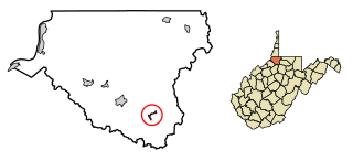
Cairo is a town in Ritchie County, West Virginia, United States, along West Virginia Route 31, the North Fork of the Hughes River, and the North Bend Rail Trail. The population was 174 at the 2020 census.

<span class="mw-page-title-main">Hambleton, West Virginia</span> Town in West Virginia, United States

Hambleton is a town in Tucker County, West Virginia, United States. The population was 216 at the 2020 census. Hambleton was established in 1889, but not incorporated until 1905. It was named by then United States Senator Stephen B. Elkins in honor of a stockholder by this name in the West Virginia Central Railroad Company. The town was previously known as Hulings.

<span class="mw-page-title-main">Smithfield, West Virginia</span> Town in West Virginia, United States

Smithfield is a town in Wetzel County, West Virginia, United States. The population was 103 at the 2020 census.

References

  1. "ArcGIS REST Services Directory". United States Census Bureau. Retrieved September 20, 2022.
  2. 1 2 U.S. Geological Survey Geographic Names Information System: Kensal, North Dakota
  3. 1 2 3 "Explore Census Data". United States Census Bureau . Retrieved November 29, 2023.
  4. 1 2 "City and Town Population Totals: 2020-2022". United States Census Bureau. November 29, 2023. Retrieved November 29, 2023.
  5. "National Register Information System". National Register of Historic Places . National Park Service. July 9, 2010.
  6. "US Gazetteer files 2010". United States Census Bureau. Archived from the original on July 2, 2012. Retrieved June 14, 2012.
  7. United States Census Bureau. "Census of Population and Housing" . Retrieved October 31, 2013.
  8. Climate Summary for Kensal, North Dakota