
Granville Township is a township in Bradford County, Pennsylvania, United States. It is part of Northeastern Pennsylvania. The population was 899 at the 2020 census. Children residing in the township are assigned to attend the Troy Area School District.
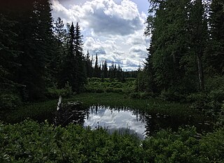
Eskers Provincial Park is a provincial park in British Columbia, Canada. The park comprises roughly 4,044 hectares and was created in 1987. Located west of Nukko Lake, which lies northwest of the city of Prince George, it protects an area of the 40-kilometre (25 mi) Stuart River Eskers Complex. Eskers are winding ridges of gravel formed by the glaciers which once covered the British Columbia Interior.
Fort George Canyon Provincial Park is a provincial park south of Prince George in British Columbia, Canada. The park's area is 440 acres (180 ha) and includes part of the Fraser River. No camping, campfires, swimming, kayaking, horses, pets, or rock climbing are allowed. Skiing, fishing, and hunting are allowed.
Gold Muchalat Provincial Park is a provincial park in British Columbia, Canada, located between the Gold and Muchalat Rivers.
Pine River Breaks Provincial Park is a provincial park in British Columbia, Canada in the Peace River Lowland between the communities of East Pine and Chetwynd.
Freeland is a Canadian rural community in Prince County, Prince Edward Island.
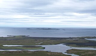
Papey is an island near the east coast of Iceland in the municipality Djúpavogshreppur and is about 2 square kilometres (0.77 sq mi) in extent, the highest point on the island being about 58 metres (190 ft) above sea level.

Beisigl Township is a township in Adams County, North Dakota, United States. As of the 2010 census, its population was 22.
Holt Township is a defunct civil township in Adams County, North Dakota, United States. The 1960 census recorded a population of 69.
Alamgarh is a town and union council of Gujrat District, in the Punjab province of Pakistan.
La Carrera is a parish in Siero, a municipality within the province and autonomous community of Asturias, in northern Spain. It is located south of Highway N-634 and north of Highway A-64. The capital, Pola de Siero, is to the northeast.

Fimbulheimen is a mountain range in Queen Maud Land, Antarctica. It stretches from Jutulstraumen by 1° west of Carsten Borchgrevink Ice at 18° east, about 200 km from the ice edge. Fimbulheimen is thus between Maudheim Plateau and Sør-Rondane.

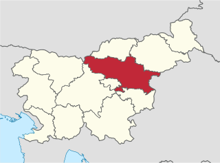
The Mura Statistical Region is a statistical region in northeast Slovenia. It is predominantly agricultural with field crops representing over three-quarters of the total agricultural area. Climate and soil combined have made it the region with the highest crop production, but its geographical position and inferior infrastructure put it at a disadvantage and it is the region of Slovenia with the lowest GDP per capita and the highest rate of registered unemployment.
The Savinja Statistical Region is a statistical region in Slovenia. The largest town in the region is Celje. It is named after the Savinja River. The region is very diverse in natural geography; it mainly comprises the wooded mountainous terrain attractive to tourists, the fertile Lower Savinja Valley with good conditions for growing hops, the Kozje Hills, and the Velenje Basin with lignite deposits, used for electricity production. In 2013 the region invested more than EUR 127 million in environmental protection. In 2013, the region accounted for 14% of enterprises created and 8% of enterprises shut down. The region has good natural conditions for agriculture. In 2013 this region had more than 11,000 farms, which is 15% of all farms in Slovenia, ranking the region right behind the Drava Statistical Region. In agricultural area utilised and livestock, the region was also in second place. The region is a well-known and popular tourist destination. In 2012, tourist arrivals and overnight stays in the region represented 11.1% of all tourist arrivals in Slovenia and 15.0% of all overnight stays. On average, tourists spent four nights there.

Madina is a suburb of Accra and in the La Nkwantanang Madina Municipal District, a district in the Greater Accra Region of southeastern Ghana. Madina is next to the University of Ghana and houses the Institute of Local Government. Madina is the twelfth most populous settlement in Ghana, in terms of population, with a population of 137,162 people. History has it that Madina was established by people from different ethnic backgrounds and some foreigners led by Alhaji Seidu Kardo. Madina is contained in the Madina electoral constituency of the republic of Ghana. It shares borders with Adentan Municipal on the west, the Accra Metropolitan Assembly to the South and the Akwapim South District. to the north.
Cioburciu is a village in the Slobozia District of Transnistria, Moldova. It has since 1990 been administered as a part of the breakaway Pridnestrovian Moldavian Republic (PMR).
Mont Carmel is a Canadian unincorporated area in Prince County, Prince Edward Island. The community is located in the "Evangeline Region" which is a cluster of Acadian communities in the central part of Prince County. The village is home to the Notre-dame-du-Mont-Carmel, a massive 450000-brick Catholic church built in 1898.

Enravota Glacier is the 10 km long and 3.5 km wide glacier on Nordenskjöld Coast in Graham Land situated southwest of Vrachesh Glacier and north of lower Drygalski Glacier. It drains the south slopes of Ruth Ridge, and flows southeastwards to join Drygalski Glacier east of Bekker Nunataks. The feature is named after the Bulgarian prince St. Boyan-Enravota.