County Hall, Haverfordwest

Last updated

County Hall
Neuadd y Sir
Pembrokeshire county hall.jpg
Pembrokeshire UK location map.svg
Red pog.svg
County Hall
Location within Pembrokeshire
General information
Architectural styleModern
AddressCounty Hall
Freemens Way
Haverfordwest
SA61 1TP
Town or city Haverfordwest
Country United Kingdom
Coordinates 51°48′06″N4°57′59″W / 51.80169°N 4.96628°W / 51.80169; -4.96628
Completed1999
Design and construction
Architect(s)Tim Colquhoun

The County Hall (Welsh : Neuadd y Sir) is a municipal building on Freemens Way in Haverfordwest, Pembrokeshire, Wales. It was built in 1999 and serves as the offices and meeting place of Pembrokeshire County Council.

History

An earlier Pembrokeshire County Council had existed from 1889 until 1974, when local government reorganisation abolished the administrative county of Pembrokeshire, splitting the area into two districts called Preseli (renamed Preseli Pembrokeshire in 1987) and South Pembrokeshire, both of which were within a new county of Dyfed. [1] [2] That first county council had met at Shire Hall, Haverfordwest, and from 1923 had its main administrative offices at a converted hospital on St Thomas's Green, Haverfordwest, called County Offices. [3]

Further local government reorganisation in 1996 abolished Dyfed County Council and its constituent districts. A unitary authority called Pembrokeshire was created covering the combined area of the abolished Preseli Pembrokeshire and South Pembrokeshire districts. [4] The new Pembrokeshire County Council inherited the former County Offices and Shire Hall from Dyfed County Council as well as Cambria House in Haverfordwest from Preseli Pembrokeshire District Council (which had been built in 1965 for Haverfordwest Rural District Council) [5] and Llanion Park in Pembroke Dock from South Pembrokeshire District Council (which had been built in 1904 as part of Llanion Barracks and had become the headquarters of the old Pembroke Borough Council in the early 1970s). [6]

The new Pembrokeshire County Council was elected in 1995, acting as a shadow authority until it formally assumed its powers in 1996. The shadow authority debated where the new council should meet, with arguments advanced in favour of Haverfordwest, Pembroke Dock and Milford Haven. It was decided initially to use Cambria House in Haverfordwest, but with full council meetings held at the larger council chamber in the old Shire Hall. [7]

East elevation with main entrance facing Freemens Way. Pembrokeshire County Hall (east front).jpg
East elevation with main entrance facing Freemens Way.

It was decided shortly after the new council's creation to build a new headquarters adjoining Cambria House. The project was overseen by the county architect, Tim Colquhoun. [8] The new building was sited on the banks of the Western Cleddau, and straddles a tributary of the river. A river walkway along the eastern bank of the river was created within the new County Hall site, linking New Bridge to the north with the public open space to the south. The building is arranged with four large bastion towers evenly spaced along its length, with the main reception and council chamber incorporated into the rounded space inside the towers. A smaller rectangular clock tower projects from the front (east) elevation facing Freemens Way. [9]

The first full council meeting in the new building was held in October 1999. [10] Cambria House was demolished the following year and its site was incorporated into the landscaping and car park in front of County Hall. The council's other offices at Llanion Park in Pembroke Dock subsequently became the headquarters of the Pembrokeshire Coast National Park Authority, whilst the old County Offices building in Haverfordwest was demolished to make way for a leisure centre. [3] [11]

The new County Hall was formally opened by Queen Elizabeth II on 22 November 2001. The building was reported to have cost £10 million. [12]

Related Research Articles

<span class="mw-page-title-main">Dyfed</span> Preserved county of Wales

Dyfed is a preserved county in southwestern Wales. It is a mostly rural area with a coastline on the Irish Sea and the Bristol Channel.

<span class="mw-page-title-main">Pembrokeshire</span> County and historic county in southwest Wales

Pembrokeshire is a county in the south-west of Wales. It is bordered by Carmarthenshire to the east, Ceredigion to the northeast, and is otherwise surrounded by the sea. Haverfordwest is the largest town and administrative headquarters of Pembrokeshire County Council.

<span class="mw-page-title-main">Fishguard</span> Town in Pembrokeshire, Wales

Fishguard is a coastal town in Pembrokeshire, Wales, with a population of 3,419 in 2011; the community of Fishguard and Goodwick had a population of 5,407. Modern Fishguard consists of two parts, Lower Fishguard and the "Main Town". Fishguard and Goodwick are twin towns with a joint Town Council.

<span class="mw-page-title-main">Haverfordwest</span> Human settlement in Wales

Haverfordwest is the county town of Pembrokeshire, Wales, and the most populous urban area in Pembrokeshire with a population of 14,596 in 2011. It is also a community, being the second most populous community in the county, with 12,042 people, after Milford Haven. The suburbs include the former parish of Prendergast, Albert Town and the residential and industrial areas of Withybush.

<span class="mw-page-title-main">Pembroke, Pembrokeshire</span> Human settlement in Wales

Pembroke is both a town and a community in Pembrokeshire, Wales, with a population of 7,552. The names of both the town and the county have a common origin; both are derived from the Cantref of Penfro: Pen, "head" or "end", and bro, "region", "country", "land", which has been interpreted to mean either "Land's End" or "headland".

<span class="mw-page-title-main">Pembroke Dock</span> Human settlement in Wales

Pembroke Dock is a town and a community in Pembrokeshire, South West Wales, 3 miles (4.8 km) northwest of Pembroke on the banks of the River Cleddau. Originally Paterchurch, a small fishing village, Pembroke Dock town expanded rapidly following the construction of the Royal Navy Dockyard in 1814. The Cleddau Bridge links Pembroke Dock with Neyland.

<span class="mw-page-title-main">Neyland</span> Human settlement in Wales

Neyland is a town and community in Pembrokeshire, Wales, lying on the River Cleddau and the upstream end of the Milford Haven estuary. The Cleddau Bridge carrying the A477 links Pembroke Dock with Neyland.

<span class="mw-page-title-main">South Pembrokeshire</span> Former district of Dyfed, Wales

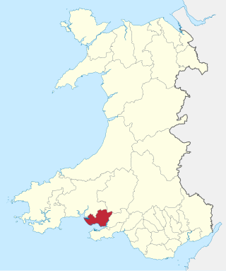
South Pembrokeshire was one of six local government districts of Dyfed, Wales from 1974 to 1996.

<span class="mw-page-title-main">Preseli Pembrokeshire (UK Parliament constituency)</span> Parliamentary constituency in the United Kingdom, 1997 onwards

Preseli Pembrokeshire is a seat and constituency of the House of Commons of the Parliament of the United Kingdom.

<span class="mw-page-title-main">Haverfordwest Airport</span> Airport in Rudbaxton, Pembrokeshire

Haverfordwest Airport, also known as Withybush Airport, is a minor airport located 2 NM north of Haverfordwest, Pembrokeshire. It is on the site of the former RAF Haverfordwest, which was operational between 1943 and 1945. Pembrokeshire County Council bought the site in the 1950s, and it has been a civil airfield since, with a number of other organisations also using it.

<span class="mw-page-title-main">Preseli Pembrokeshire</span> Former district of Dyfed, Wales

Preseli Pembrokeshire was one of six local government districts of Dyfed in West Wales from 1974 to 1996. Until 1987 the name of the district was Preseli. The district took its name from the Preseli Hills.

Pembrokeshire was a parliamentary constituency based on the county of Pembrokeshire in Wales. It returned one Member of Parliament (MP) to the House of Commons of the Parliament of the United Kingdom, elected by the first past the post system.

Pembroke was a parliamentary constituency centred on the town of Pembroke in West Wales. It returned one Member of Parliament (MP) to the House of Commons of the Parliament of the United Kingdom, elected by the first past the post system.

<span class="mw-page-title-main">Pembrokeshire County Council</span> Local government of Pembrokeshire, Wales

Pembrokeshire County Council is the local authority for the county of Pembrokeshire, one of the principal areas of Wales.

<span class="mw-page-title-main">Dyfed County Council</span>

Dyfed County Council was the county council of the non-metropolitan county of Dyfed in south west Wales. It operated between 1974 and 1996. The county council was based at County Hall, Carmarthen.

The first elections to Pembrokeshire County Council was held on 4 May 1995. It was followed by the 1999 election. On the same day there were elections to the other 21 local authorities in Wales and community councils in Wales.

<span class="mw-page-title-main">Pembrokeshire County Council, 1889–1974</span>

The first Pembrokeshire County Council was established in 1889 under the Local Government Act 1888, to govern the administrative county of Pembrokeshire. This first county council was abolished in 1974 under the Local Government Act 1972.

<span class="mw-page-title-main">Pembroke Dock Llanion</span> Electoral ward in Wales

Pembroke Dock Llanion was the name of a county electoral ward in the town of Pembroke Dock, Pembrokeshire, Wales. Llanion remains as a ward for elections to Pembroke Dock Town Council.

<span class="mw-page-title-main">Pembroke Town Hall</span> Municipal Building in Pembroke, Wales

Pembroke Town Hall is a municipal building in Main Street, Pembroke, Pembrokeshire, Wales. The structure, which is the meeting place of Pembroke Town Council, is a Grade II listed building.

Haverfordwest Rural District was a rural district in the administrative county of Pembrokeshire, Wales from 1894 to 1974, covering an area in the west of the county. It surrounded, but did not include, the town of Haverfordwest after which it was named.

References

  1. "Local Government Act 1972", legislation.gov.uk , The National Archives, 1972 c. 70, retrieved 31 July 2022
  2. "The Districts in Wales (Names) Order 1973", legislation.gov.uk , The National Archives, SI 1973/1, retrieved 31 July 2022
  3. 1 2 Swales Barker, Patricia (2013). Haverfordwest through time. Stroud: Amberley Publishing. p. 82. ISBN   978-1-4456-1614-8 . Retrieved 4 August 2022.
  4. "Local Government (Wales) Act 1994", legislation.gov.uk , The National Archives, 1994 c. 19, retrieved 7 August 2022
  5. Swales Barker, Patricia (2013). Haverfordwest through time. Stroud: Amberley Publishing. p. 54. ISBN   978-1-4456-1614-8.
  6. 1971 Telephone Directory: Pembroke Borough Council - Administration, Municipal Offices, Bush Street, Pembroke Dock / 1972 Telephone Directory: Pembroke Borough Council - All Departments, Llanion Barracks, Pembroke Dock
  7. "Shadow Authority minutes, 15 May 1995" (PDF). Pembrokeshire County Council. Retrieved 8 August 2022.
  8. Lloyd, Thomas; Orbach, Julian; Scourfield, Robert; Scourfield, Richard; Hughes, Stephen (2004). Pembrokeshire. Yale University Press. p. 109. ISBN   978-0300101782.
  9. "Modern times 1900 – the present". Haverfordwest Civic Society. Retrieved 8 August 2022.
  10. "Council minutes, 28 October 1999" (PDF). Pembrokeshire County Council. Retrieved 3 August 2022.
  11. Rees, Derek (22 February 2007). "Townsfolk witness end of an era". Western Telegraph. Retrieved 8 August 2022.
  12. "Royals open £10m county hall". BBC News. 22 November 2001. Retrieved 1 August 2022.