Mountain Ash Town Hall

Last updated

Mountain Ash Town Hall
Native name
Neuadd y Dref Aberpennar
South side of Mountain Ash Town Hall (geograph 3830546).jpg
Mountain Ash Town Hall
LocationFfrwd Crescent, Mountain Ash
Coordinates 51°41′03″N3°22′44″W / 51.6841°N 3.3788°W / 51.6841; -3.3788
Built1904
ArchitectJ. H. Phillips
Architectural style(s) Baroque style
Listed Building – Grade II
Official nameMountain Ash Town Hall
Designated18 February 2003
Reference no.80903
Rhondda Cynon Taf UK location map.svg
Red pog.svg
Shown in Rhondda Cynon Taf County Borough

Mountain Ash Town Hall (Welsh : Neuadd y Dref Aberpennar) is a municipal structure in Ffrwd Crescent, Mountain Ash, Rhondda Cynon Taf, Wales. The town hall, which was the headquarters of Mountain Ash Urban District Council, is a Grade II listed building. [1]

History

Following significant population growth, largely associated with coal mining industry, the area became an urban district in 1894. [2] [3] In this context the new civic leaders decided to procure a municipal building: the site they chose had been unoccupied since the Nixon's Workmen's Institute relocated to the southwest side of the River Cynon in 1899. [4] [5] The rear aspect of the site, which was acquired for £1,000, [6] was bounded by the Aberdare Canal. [1]

The new building was the subject of a design competition which was won by J. H. Phillips of Cardiff. [1] It was designed in the Baroque style, built in rubble masonry with ashlar stone dressings at a cost of £5,000 and was completed in 1904. [1] The design involved an asymmetrical main frontage with nine bays facing onto Ffrwd Crescent; the central section of five bays, which was slightly recessed, featured a doorway flanked by pilasters and brackets supporting a segmental pediment containing a cartouche. [1] There was a balcony and a French door on the first floor, while the other bays in the central section contained casement windows which were separated by full-height pilasters. [1] The bay to the left of the central section featured a panel with a cartouche above the first floor window, while the bay to the right of the central section featured an oculus on the ground floor and a panel with a cartouche on the first floor. [1] The last two bays on the right formed a wing which was significantly set back. [1] There was a clock tower surmounted by a cupola and a weather vane at roof level. [1] Internally, the principal room was the concert hall which was capable of accommodating 500 people. [7]

The Aberdare Canal, at the rear of the property, ceased to be used for water transport in the early 1920s and was filled in to form the New Cardiff Road in 1933. [8] The town hall continued to serve as the headquarters of Mountain Ash Urban District Council for much of the 20th century but ceased to be the local seat of government when the enlarged Cynon Valley District Council was formed in 1974. [9] The building was subsequently used for the delivery of local services by Cynon Valley District Council and, after 1996, as workspace by the Leisure Department of Rhondda Cynon Taf County Borough Council. [7]

The council announced, in March 2021, that, following the award of a grant of £250,000 from the Valleys Taskforce, the building would be converted for use as a co-working hub for small businesses. [10] [11]

Related Research Articles

<span class="mw-page-title-main">Rhondda Cynon Taf</span> County borough in Wales

Rhondda Cynon Taf is a county borough in the south-east of Wales. It consists of five valleys: the Rhondda Fawr, Rhondda Fach, Cynon, Taff and Ely valleys, plus a number of towns and villages away from the valleys.

<span class="mw-page-title-main">Cynon Valley</span>

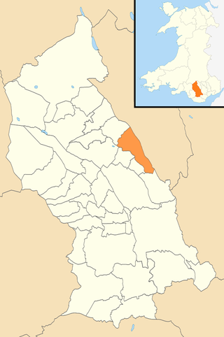
Cynon Valley is a former coal mining valley in Wales. It lies between Rhondda and the Merthyr Valley and takes its name from the River Cynon. Aberdare is located in the north of the valley and Mountain Ash in the south. From 1974 to 1996, Cynon Valley was a local government district.

<span class="mw-page-title-main">Mountain Ash, Rhondda Cynon Taf</span> Town in Cynon Valley, Wales

Mountain Ash is a town and former community in the Cynon Valley, within the County Borough of Rhondda Cynon Taf, Wales, with a population of 11,230 at the 2011 Census, estimated in 2019 at 11,339. It includes the districts and villages of Cefnpennar, Cwmpennar, Caegarw, Darranlas, Fernhill, Glenboi and Newtown, all within the historic county boundaries of Glamorgan. Aberdare lies about 4.5 miles (7.2 km) north-west, Cardiff 19 miles (31 km) south-east, and Penrhiwceiber a mile to the south-east. It divides into two communities : West covers the town centre and the districts of Miskin, Darranlas, Fernhill and Glenboi, and East the districts of Cefnpennar, Cwmpennar, Caegarw and Newtown.

<span class="mw-page-title-main">Ynysybwl</span> Human settlement in Wales

Ynysybwl is a village in Cwm Clydach in Wales. It is situated in the county borough of Rhondda Cynon Taf, roughly 15 miles (24 km) north-north-west of Cardiff, 4 miles (6 km) north of Pontypridd and 16 miles (26 km) south of Merthyr Tydfil, and forms part of the community of Ynysybwl and Coed-y-Cwm.

<span class="mw-page-title-main">Abercynon</span> Human settlement in Wales

Abercynon, is both a village and a community in the Cynon Valley within the unitary authority of Rhondda Cynon Taf, Wales. The community comprises the village and the districts of Carnetown and Grovers Field to the south, Navigation Park to the east, and Glancynon to the north.
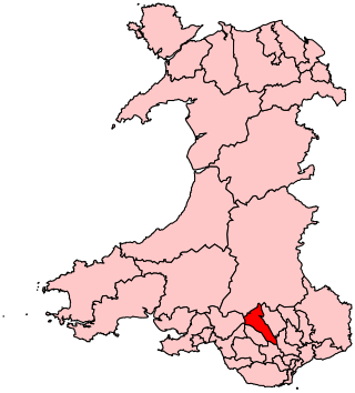
<span class="mw-page-title-main">Cynon Valley (UK Parliament constituency)</span> Parliamentary constituency in the United Kingdom, 1983 onwards

Cynon Valley is a constituency in Wales represented in the House of Commons of the UK Parliament since 2019 by Beth Winter of the Labour Party.

<span class="mw-page-title-main">Hirwaun</span> Human settlement in Wales

Hirwaun is a village and community at the north end of the Cynon Valley in the County Borough of Rhondda Cynon Taf, South Wales. It is 4 miles (6 km) NW of the town of Aberdare, and comes under the Aberdare post town. At the 2001 census, Hirwaun had a population of 4,851. increasing at the 2011 census to 4,990. The village is on the Heads of the Valleys Road and at the southern edge of the Brecon Beacons National Park.

<span class="mw-page-title-main">Aberaman</span> Human settlement in Wales

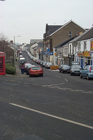
Aberaman is a village near Aberdare in the county borough of Rhondda Cynon Taf, south Wales. It was heavily dependent on the coal industry and the population, as a result, grew rapidly in the late nineteenth century. Most of the industry has now disappeared and a substantial proportion of the working population travel to work in Cardiff and the M4 corridor. Many residents also work in the nearby towns of Aberdare and Pontypridd.

<span class="mw-page-title-main">Abercwmboi</span> Human settlement in Wales

Abercwmboi is a village in the Welsh county borough of Rhondda Cynon Taf in Wales, United Kingdom.

<span class="mw-page-title-main">Taff's Well</span> Human settlement in Wales

Taff's Well is a semi-rural village, community and electoral ward located at the south easterly tip of Rhondda Cynon Taf, 6 miles (9.7 km) to the north of Cardiff, the capital city of Wales. Known locally as the 'Gates to the Valleys', it is separated from Gwaelod-y-Garth by the River Taff. Taff's Well is distinguished because it contains the only thermal spring in Wales. The tepid water is thought to rise along a fault-line from the Carboniferous Limestone, in somewhat similar manner to the warm springs at Bristol and Bath. Various religious groups regard it as a spiritual site.

<span class="mw-page-title-main">Mountain Ash railway station</span> Railway station in Rhondda Cynon Taf, Wales

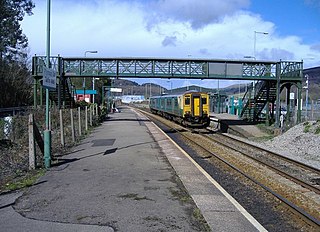
Mountain Ash Railway Station is a railway station serving the town of Mountain Ash in Rhondda Cynon Taf, Wales. It is located on the Aberdare branch of the Merthyr Line and on the banks of the Afon Cynon, a major river in the town of Mountain Ash.

<span class="mw-page-title-main">River Cynon</span> River in south Wales

The River Cynon in South Wales is a main tributary of the Taff. Its source is the rising of Llygad Cynon at 219 m (719 ft) above sea level at Penderyn, Rhondda Cynon Taf and flows roughly southeast, into the Taff at Abercynon in the same district. The water emerging at Llygad Cynon has been traced back to the sink of the Nant Cadlan at Ogof Fawr.

<span class="mw-page-title-main">Rhondda Cynon Taf County Borough Council</span> Local government of Rhondda Cynon Taf, Wales

Rhondda Cynon Taf County Borough Council is the governing body for Rhondda Cynon Taf, one of the Principal Areas of Wales. The council headquarters are located in the community of Cwm Clydach on the outskirts of Tonypandy.

<span class="mw-page-title-main">Cwm Taf Morgannwg University Health Board</span> NHS local health board in South Wales

Cwm Taf Morgannwg University Health Board (CTMUHB) is the local health board of NHS Wales for Merthyr Tydfil, Rhondda Cynon Taf, and Bridgend in the south of Wales. It was renamed from Cwm Taf University Health Board on 1 April 2019 following the transfer of Bridgend County Borough from the former Abertawe Bro Morgannwg University Health Board.

<span class="mw-page-title-main">Penderyn, Rhondda Cynon Taf</span> Village in Rhondda Cynon Taf, Wales

Penderyn is a rural village in the Cynon Valley, Rhondda Cynon Taf, Wales, located near Hirwaun.

Aberdare Town was, for much of the twentieth century, an electoral ward for the purposes of electing members to Glamorgan County Council and the Aberdare Urban District Council. It currently comprises two electoral wards, Aberdare East and Aberdare West/Llwydcoed, for the purposes of electing members to the Rhondda Cynon Taf County Borough Council. Aberdare East is composed mainly of a part of Aberdare itself while Aberdare West includes the community of Llwydcoed which, for many years was itself as electoral ward.

The Cynon Valley Party is a political party formed in 2016 to campaign for people living in the Cynon Valley, including the towns of Aberdare and Mountain Ash, in Rhondda Cynon Taf, South Wales. The party won a council seat on Rhondda Cynon Taf County Borough Council in May 2017.

<span class="mw-page-title-main">Mountain Ash East</span> Human settlement in Wales

Mountain Ash East is a community and coterminous electoral ward in Rhondda Cynon Taf, Wales. It primarily includes the part of the town of Mountain Ash east of the River Cynon. The community was formed in 2016 when the larger community of Mountain Ash was divided into East and West to match the ward boundaries.

<span class="mw-page-title-main">Ysbyty Cwm Cynon</span> Hospital in Rhondda Cynon Taf, Wales

Ysbyty Cwm Cynon is a health facility on New Road, Mountain Ash, Rhondda Cynon Taf, Wales. It is managed by the Cwm Taf Morgannwg University Health Board.

Mountain Ash Urban District was a local authority in Mountain Ash, in the Cynon Valley, Glamorgan, Wales. It was created in 1894 as a result of the 1894 Local Government of England and Wales Act. The council replaced the Mountain Ash Local Board of Health which had been established in 1867. Initially, the Council had fifteen members, but this was increased to eighteen in 1898. The council was based at Mountain Ash Town Hall. The urban district was abolished in 1974, becoming part of the borough of Cynon Valley, which was in turn abolished in 1996 to become part of Rhondda Cynon Taf.

References

  1. 1 2 3 4 5 6 7 8 9 Cadw. "Mountain Ash Town Hall (80903)". National Historic Assets of Wales . Retrieved 1 July 2021.
  2. "Mountain Ash UD". Vision of Britain. Retrieved 1 July 2021.
  3. "Mountain Ash Local Board". Glamorgan Record Office. Retrieved 1 July 2021.
  4. "Entertaining South Wales" (PDF). Over The Footlights. p. 47. Retrieved 1 July 2021.
  5. "Ordnance Survey Map". 1874. Retrieved 1 July 2021.
  6. Morgan, Jeremy James (2016). "Henry Austin Bruce, the Duffryn Estate and the Development of an Industrial Society: Mountain Ash 1845 – 1895" (PDF). Cardiff University. p. 97. Retrieved 1 July 2021.
  7. 1 2 "Mountain Ash Town Hall". Images of Wales. Retrieved 1 July 2021.
  8. "Mountain Ash". Rhondda Cynon Taff. Archived from the original on 18 July 2011. Retrieved 1 July 2021.
  9. Local Government Act 1972. 1972 c.70. The Stationery Office Ltd. 1997. ISBN   0-10-547072-4.
  10. "Plans for the redevelopment of two prominent buildings progressing". Wales 24/7. 16 November 2020. Retrieved 1 July 2021.
  11. "Three prominent buildings in Rhondda Cynon Taf to be brought back to life". Wales Online. 2 March 2021. Retrieved 1 July 2021.