Merthyr Tydfil Town Hall

Last updated

Merthyr Tydfil Town Hall
Native name
Neuadd y Dref Merthyr Tudful
Hen Neuadd y Dref Merthyr.jpg
Merthyr Tydfil Town Hall
LocationHigh Street, Merthyr Tydfil
Coordinates 51°44′51″N3°22′40″W / 51.7475°N 3.3778°W / 51.7475; -3.3778
Built1898
ArchitectEdwin Arthur Johnson
Architectural style(s) Renaissance style
Listed Building – Grade II*
Official nameTown Hall
Designated22 August 1975
Reference no.11444
Merthyr Tydfil UK location map.svg
Red pog.svg
Shown in Merthyr Tydfil County Borough

Merthyr Tydfil Town Hall (Welsh : Neuadd y Dref Merthyr Tudful) is a municipal building in the High Street, Merthyr Tydfil, South Wales. The town hall, which was the headquarters of Merthyr Tydfil County Borough Council, is a Grade II* listed building. [1]

History

The local board of health for Merthyr Tydfil, which was established under the chairmanship of Sir John Guest, in 1850, [2] initially established its offices at 71 High Street. [3] Proposals for a new town hall were considered in 1869, but the local board decided that such a development could not be afforded at that time. [2] Following significant population growth, particularly associated with the coal mining industry, the area became an urban district in 1894. [4] The new civic leaders decided to proceed with the town hall development: the site they close was open land on the corner of the High Street and New Castle Street, just to the north of the old offices of the local board of health. [5]

The foundation stone for the new building was laid in May 1896. [2] It was designed by Edwin Arthur Johnson in the Renaissance style, built in red Cattybrook brick with orange terracotta dressings by Harry Gibbon and completed in 1898. [6] [7] The design involved a symmetrical main frontage with seven bays facing onto the High Street with the end bays slightly projected forward with bay windows and gables; the central bay, which also slightly projected forward, featured a rounded headed doorway which was flanked by brackets supporting heraldic lions and full-height pilasters; there was a cantilevered balcony and a mullioned window on the first floor and a gable above. [1] Internally, the principal rooms were the council chamber and the courtroom at the rear of the building. [1]

The election of the future leader of the Labour Party, Keir Hardie, as member of parliament for Merthyr Tydfil was announced from the steps of the town hall In September 1900. [1] Subsequent election successes were announced from the balcony. [1] A town hall clock, supplied by Flooks & Williams, was installed in a tower above the town hall and officially started on 22 April 1903. [2] The town became a municipal borough with the town hall as its headquarters in 1905 and a county borough with the town hall as its headquarters in 1908. [4] [8] The quarter sessions were held in the town hall for the first time in 1910. [2]

The town hall continued to serve as the borough headquarters for much of the 20th century and, from 1974, as the headquarters of the enlarged Merthyr Tydfil District Council. [9] After the courts relocated to the new Law Courts in Glebeland Place in 1977, [10] and after the council relocated to the new Merthyr Tydfil Civic Centre in the late 1980s, the town hall became a night club. [11] The nightclub closed in 2002 and after that the building lay derelict until 2012 when it was restored by Merthyr Tydfil Housing Association with funding from the Heritage Lottery Fund, Cadw and Merthyr Tydfil County Borough Council. [11] The restoration works were carried out by Graham Construction to a design by Austin-Smith:Lord. [12] The Prince of Wales reviewed the works in February 2014 and the building was officially re-opened as an arts and creative industries centre known as the Red House by the actor, Richard Harrington, on 1 March 2014. [13] The area in front of the town hall, which had been the scene of the Merthyr Rising in 1831, [14] was remodelled as a new public space known as Penderyn Square and re-opened by the Minister for Finance, Jane Hutt, on 20 September 2014. [15]

Related Research Articles

<span class="mw-page-title-main">Merthyr Tydfil</span> Town in Wales

Merthyr Tydfil is the main town in Merthyr Tydfil County Borough, Wales, administered by Merthyr Tydfil County Borough Council. It is about 23 miles (37 km) north of Cardiff. Often called just Merthyr, it is said to be named after Tydfil, daughter of King Brychan of Brycheiniog, who according to legend was slain at Merthyr by pagans about 480 CE. Merthyr generally means "martyr" in modern Welsh, but here closer to the Latin martyrium: a place of worship built over a martyr's relics. Similar place names in south Wales are Merthyr Cynog, Merthyr Dyfan and Merthyr Mawr.

<span class="mw-page-title-main">Mid Glamorgan</span> Preserved county in Wales

Mid Glamorgan is a preserved county of Wales. From 1974 until 1996 it was also an administrative county with a county council.

<span class="mw-page-title-main">Merthyr Rising</span> Violent labour protest in Merthyr Tydfil, Wales

The Merthyr Rising, also referred to as the Merthyr Riots, of 1831 was the violent climax to many years of simmering unrest among the large working class population of Merthyr Tydfil in Wales and the surrounding area. The Rising marked the first times the red flag was used a symbol of working class rebellion in the United Kingdom.

<span class="mw-page-title-main">Merthyr Tydfil and Rhymney (UK Parliament constituency)</span> Parliamentary constituency in the United Kingdom, 1983 onwards

Merthyr Tydfil and Rhymney is a constituency represented in the House of Commons of the UK Parliament since 2015 by Gerald Jones of the Welsh Labour Party. It was established for the 1983 general election.

<span class="mw-page-title-main">Hirwaun</span> Human settlement in Wales

Hirwaun is a village and community at the north end of the Cynon Valley in the County Borough of Rhondda Cynon Taf, South Wales. It is 4 miles (6 km) NW of the town of Aberdare, and comes under the Aberdare post town. At the 2001 census, Hirwaun had a population of 4,851. increasing at the 2011 census to 4,990. The village is on the Heads of the Valleys Road and at the southern edge of the Brecon Beacons National Park.

<span class="mw-page-title-main">Vaynor</span>

Vaynor is a village and community in Merthyr Tydfil County Borough in Wales, United Kingdom. The population of the community at the 2011 census was 3,551.

<span class="mw-page-title-main">Cyfarthfa Castle</span> Historic house museum, art museum in Merthyr Tydfil, Wales

Cyfarthfa Castle is a castellated mansion that was the home of the Crawshay family, ironmasters of Cyfarthfa Ironworks in Park, Merthyr Tydfil, Wales. The house commanded a view of the valley and the works, which ‘at night, offer a truly magnificent scene, resembling the fabled Pandemonium, but on which the eye may gaze with pleasure’. Cyfarthfa loosely translates from the Welsh for place of barking. The reason is hunting dogs were regularly heard in this area of the town, hunting polecats and weasels among others.

<span class="mw-page-title-main">Merthyr Tydfil County Borough Council</span> Local government of Merthyr Tydfil County Borough, Wales

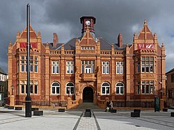
Merthyr Tydfil County Borough Council is the governing body for Merthyr Tydfil County Borough, one of the Principal Areas of Wales.

<span class="mw-page-title-main">Merthyr Synagogue</span> Grade II listed building in Merthyr Tydfil.

The former Merthyr Synagogue is located on Bryntirion Road in the Thomastown section of Merthyr Tydfil, Wales. It is a Grade II listed building and is the oldest purpose-built synagogue still standing in Wales.

<span class="mw-page-title-main">Cefn-coed-y-cymmer</span> Historic site

Cefn-coed-y-cymmer is a small community on the northwestern edge of Merthyr Tydfil County Borough in Wales. It is situated in the neck of land between the rivers Taf Fawr and Taf Fechan at their confluence. The village lies within the community of Vaynor. Immediately to the north of the village is the hill of Cefn Cil Sanws on the southern slopes of which is Merthyr Tydfil Golf Club. The village is bounded both to the north and the west by the Brecon Beacons National Park.

<span class="mw-page-title-main">Canolfan Soar</span>

Canolfan Soar is a Grade II-listed community facility in Merthyr Tydfil, Wales, that includes a theatre and other facilities. It was converted from the closed Grade II-listed, eighteenth-century, Zoar Chapel in the first decade of the twenty-first century.

<span class="mw-page-title-main">Merthyr Tydfil bus station</span> Bus station in Merthyr Tydfil, Wales

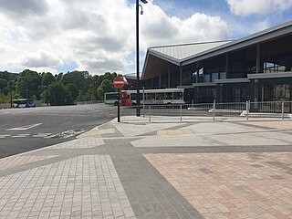
Merthyr Tydfil bus station is the bus station that serves the town of Merthyr Tydfil, South Wales.

<span class="mw-page-title-main">Merthyr Tydfil County Borough</span> County borough in Wales

Merthyr Tydfil County Borough is a county borough in the south-east of Wales. In mid 2018, it had an estimated population of 60,183 making it the smallest local authority in Wales by both population and land area. It is located in the historic county of Glamorgan and takes its name from the town with the same name. The county borough consists of the northern part of the Taff Valley and the smaller neighbouring Taff Bargoed Valley. It borders the counties of Rhondda Cynon Taf to the west, Caerphilly County Borough to the east, and Powys to the north.

<span class="mw-page-title-main">Grade I listed buildings in Merthyr Tydfil County Borough</span> List of buildings in county borough of Wales

Merthyr Tydfil County Borough is located in the historic county of Glamorgan in Wales and takes its name from its largest town. The county borough covers an area of 111 km2 (43 sq mi) and had a population of approximately 58,900 in 2021.

<span class="mw-page-title-main">Grade II* listed buildings in Merthyr Tydfil County Borough</span> List of buildings in county borough of Wales

Merthyr Tydfil County Borough is located in the historic county of Glamorgan in Wales and takes its name from its largest town. The county borough covers an area of 111 km2 (43 sq mi) and had a population of approximately 58,900 in 2021. There are ten structures on the list of twelve Grade II* listed buildings in Merthyr Tydfil. Two viaducts constructed as part of the Brecon and Merthyr Railway both straddle the borders of neighbouring communities so have separate designations for each of these locations.

<span class="mw-page-title-main">Tredegar Town Hall</span> Municipal Building in Tredegar, Wales

Tredegar Town Hall is a municipal structure in The Circle, Tredegar, Wales. The town hall, which was the headquarters of Tredegar Urban District Council, is a Grade II listed building.

<span class="mw-page-title-main">Flint Town Hall</span> Municipal Building in Flint, Wales

Flint Town Hall is a municipal structure in the Market Square, Flint, Flintshire, Wales. The town hall, which is the meeting place of Flint Town Council, is a Grade II listed building.

<span class="mw-page-title-main">Lampeter Town Hall</span> Municipal Building in Lampeter, Wales

Lampeter Town Hall is a municipal structure in the High Street, Lampeter, Wales. The town hall, which was the meeting place of Lampeter Borough Council, is a Grade II listed building.

<span class="mw-page-title-main">Shire Hall, Llangefni</span> County building in Llangefni, Wales

The Shire Hall is a municipal structure in Glanhwfa Road, Llangefni, Anglesey, Wales. The building, which served as the headquarters of Anglesey County Council, is a Grade II listed building.

<span class="mw-page-title-main">Merthyr Tydfil Law Courts</span> Court building in Merthyr Tydfil, Wales

Merthyr Tydfil Law Courts is a Crown Court venue which deals with criminal cases, as well as a County Court, which deals with civil cases, in Glebeland Place, Merthyr Tydfil, Wales. It also accommodates the local magistrates' court.

References

  1. 1 2 3 4 5 Cadw. "The Town Hall (11444)". National Historic Assets of Wales . Retrieved 23 March 2021.
  2. 1 2 3 4 5 Heir, Thomas. "Chronological List of events in the History of Merthyr Tydfil" . Retrieved 23 March 2021.
  3. "Kelly's Directory of South Wales". 1895. Retrieved 23 March 2021.
  4. 1 2 "Merthyr Tudful UD/MB/CB". Vision of Britain. Retrieved 23 March 2021.
  5. "Ordnance Survey Map". 1875. Retrieved 23 March 2021.
  6. "Old Town Hall, Merthyr Tydfil". Basha-Franklin. Retrieved 23 March 2021.
  7. "Heritage Plaques - Structures" (PDF). Merthyr Tydfil Heritage Regeneration Trust. Archived (PDF) from the original on 14 January 2022. Retrieved 14 January 2022.
  8. "Merthyr Tydfil Borough, Records". Archives Hub. Retrieved 23 March 2021.
  9. Local Government Act 1972. 1972 c.70. The Stationery Office Ltd. 1997. ISBN   0-10-547072-4.
  10. Mulcahy, Linda; Rowden, Emma (2019). The Democratic Courthouse: A Modern History of Design, Due Process and Dignity. Taylor and Francis. ISBN   978-0429558689. Hove Trial Centre (1972), Kingston upon Thames Crown Court (1974), Winchester Combined Court (1974), Merthyr Tydfil Combined Court (1977) and Shrewsbury (1966) were built in the modernist style
  11. 1 2 "£2m for Merthyr town hall revamp into culture centre". BBC. 24 November 2011. Retrieved 23 March 2021.
  12. "Restoring Merthyr Tydfil's old town hall". Premier Construction News. 9 April 2013. Retrieved 23 March 2021.
  13. "Merthyr town hall receives £8m new lease of life as arts centre". BBC. 1 March 2014. Retrieved 23 March 2021.
  14. "Opportunity for Artists, Public art commission for Penderyn Square". Celfwaith. 6 March 2018. Retrieved 23 March 2021.
  15. "History brought to life as Penderyn Festival marks official opening of new public space in Merthyr". Wales Online. 21 September 2014. Retrieved 23 March 2021.