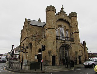
Conwy Guildhall

Last updated

Conwy Guildhall
Native name
Neuadd y Dref Conwy (Welsh)
The Guildhall at Conwy - geograph.org.uk - 1988265.jpg
Conwy Guildhall
LocationRose Hill Street, Conwy
Coordinates 53°16′49″N3°49′36″W / 53.2804°N 3.8268°W / 53.2804; -3.8268
Built1863
Architectural style(s) Gothic Revival style
Listed Building – Grade II
Official nameThe Guildhall
Designated8 October 1981
Reference no.3251
Conwy UK location map.svg
Red pog.svg
Shown in Conwy County Borough

Conwy Guildhall (Welsh : Neuadd y Dref Conwy) is a municipal structure in Rose Hill Street, Conwy, Wales. The guildhall, which is the meeting place of Conwy Town Council, is a Grade II listed building. [1]

History

The first building on the site was a medieval hall completed in the 13th century. [2] A new structure, which was arcaded on the ground floor so markets could be held, with an assembly hall on the first floor, was completed in 1613. [3] That structure was replaced by a national school in the early 19th century. [3] However, the national school moved to a new building further to the west along Rose Hill Street in 1840, and borough leaders decided to demolish the old school building and to replace it with a new civic building in the mid-19th century. [3]

The new building was designed in the Gothic Revival style, built in sandstone with Bath stone dressings and was completed in 1863. [1] The design involved a range with a gable end facing Rose Hill Street, a square tower to the right of the gable end and a flight of steps leading up from Castle Square to a porch. [4] Internally, the principal room was the council chamber. [1] Until 1877 Conwy's council was an unreformed ancient borough corporation. In 1877 the town was made a municipal borough, run by an elected borough council, which based itself at the guildhall. [5]

In the late 19th century, burgh leaders erected a public hall on the northeast side of Castle Street but this was largely used as an events venue, leaving the guildhall to continue as the main municipal building in the town. [6] The guildhall was extended to the south east to create a new council chamber in 1925. [1] The design involved a new range with a gable end facing Castle Street; the steps on the Castle Street elevation were removed and an elaborate porch was erected. [1] The new porch involved an arched doorway with a hood mould and carved quatrefoils in the spandrels, a panel inscribed with the word "guildhall" in antique lettering above the doorway, and a small pediment bearing a roundel with the borough seal above that; there was also a three light mullioned window to the right of the doorway. [1] On completion of the works, the old council chamber became the mayor's parlour. [1]

David Lloyd George, Prime Minister from 1916 to 1922, was the Member of Parliament for the Carnarvon Boroughs constituency, which included Conwy, from 1890 until 1945. He is known to have met with borough leaders at the guildhall in the 1930s. [3] [7] In 1937 the borough council acquired a large house called Bodlondeb, built in 1877 on Bangor Road, and converted the house to become its main offices. [8] [9] From 1937 until 1974 the council held its meetings at the guildhall but had its main offices at Bodlondeb. Local government reorganisation in 1974 saw the borough council abolished and the area become part of Aberconwy District. [10] Bodlondeb was extended to provide additional offices space for Aberconwy District Council and to incorporate a council chamber. After 1974, the guildhall became the meeting place of Conwy Town Council, a lower-tier community council. An extensive programme of refurbishment works was completed in 1996. [1]

Works of art in the guildhall include a portrait by John Dawson Watson of the former mayor, William Hughes, [11] a painting by Richard Wilson of Conwy Castle, [12] and a painting by Franz Emile Herman Krause depicting the rail accident which took place at Penmaenmawr in January 1899. [13]

Related Research Articles

<span class="mw-page-title-main">Caernarfonshire</span> Historic county of Wales

Until 1974, Caernarfonshire, sometimes spelled Caernarvonshire or Carnarvonshire, was an administrative county in the north-west of Wales, later classed as one of the thirteen historic counties of Wales.

<span class="mw-page-title-main">Llandudno</span> Seaside town and community in Wales

Llandudno is a seaside resort, town and community in Conwy County Borough, Wales, located on the Creuddyn peninsula, which protrudes into the Irish Sea. In the 2021 UK census, the community – which includes Gogarth, Penrhyn Bay, Craigside, Glanwydden, Penrhynside, and Bryn Pydew – had a population of 19,700. The town's name means "Church of Saint Tudno".
<span class="mw-page-title-main">Conwy County Borough</span> County borough in Wales

Conwy County Borough is a county borough in the north of Wales. It borders Gwynedd to the west and south and Denbighshire to the east. The largest settlement is Colwyn Bay, and Conwy is the administrative centre.

<span class="mw-page-title-main">Llanrwst</span> Welsh market town

Llanrwst is a market town and community on the A470 road and the River Conwy, in Conwy County Borough, Wales, and the historic county of Denbighshire. It developed around the wool trade and became known also for the making of harps and clocks. Today, less than one mile from the edge of Snowdonia, its main pursuit is tourism. Notable buildings include almshouses, two 17th-century chapels, and the Parish Church of St Grwst, which holds the stone coffin of Llywelyn the Great. The 2011 census gave it a population of 3,323.

<span class="mw-page-title-main">Conwy</span> Walled market town in Wales

Conwy, previously known in English as Conway, is a walled market town, community and the administrative centre of Conwy County Borough in North Wales. The walled town and castle stand on the west bank of the River Conwy, facing Deganwy on the east bank. The town formerly lay in Gwynedd and prior to that in Caernarfonshire. The community, which also includes Deganwy and Llandudno Junction, had a population of 14,753 at the 2011 census.

<span class="mw-page-title-main">Colwyn</span> Former district of Clwyd, Wales

Colwyn was a local government district with borough status from 1974 to 1996, being one of six districts in the county of Clwyd, north-east Wales.

<span class="mw-page-title-main">District of Aberconwy</span> Former district of Gwynedd, Wales

The Borough of Aberconwy was a local government district with borough status from 1974 to 1996, being one of five districts in the county of Gwynedd, north-west Wales.
<span class="mw-page-title-main">Dolwyddelan</span> Village in Wales

Dolwyddelan is a village and community in Conwy County Borough, Wales. The community occupies most of the valley of the Afon Lledr, and contains the settlements of Dolwyddelan, Pentre Bont, Blaenau Dolwyddelan, and Pont-y-Pant. It lies within Snowdonia, and the surrounding hills are part of the Moelwynion range. The population of the community was recorded as 454 in the 2021 census, and in the 2011 census the proportion of Welsh speakers was recorded as 50.8%.
<span class="mw-page-title-main">Llanrhos</span> Human settlement in Wales

Llanrhos is a village in the community of Conwy, in Conwy County Borough, Wales. The village lies between the towns of Conwy and Llandudno. Llanrhos was a civil parish from 1894 until 1974. The area was formerly part of a larger parish called Eglwys Rhos or Eglwysrhos, being an old variant name for the same village. The ancient parish included Deganwy, the Craig-y-Don district of Llandudno, the Little Orme and Penrhyn Bay. The area was in the administrative county of Caernarfonshire prior to 1974.

<span class="mw-page-title-main">Bodysgallen Hall</span> Historic manor house in Wales

Bodysgallen Hall is a manor house in Conwy county borough, north Wales, near the village of Llanrhos. Since 2008 the house has been owned by The National Trust. It is a Grade I listed building, currently used as a hotel. This listed historical building derives primarily from the 17th century, and has several later additions. Bodysgallen was constructed as a tower house in the Middle Ages to serve as defensive support for nearby Conwy Castle. According to tradition, the site of Bodysgallen was the 5th century AD stronghold of Cadwallon Lawhir, King of Gwynedd, who had wide-ranging exploits as far as Northumberland.
<span class="mw-page-title-main">Conwy County Borough Council</span> Local government authority in central north Wales

Conwy County Borough Council is the local authority for Conwy County Borough, one of the principal areas of Wales.

<span class="mw-page-title-main">Grade I listed buildings in Conwy County Borough</span>

In the United Kingdom, the term listed building refers to a building or other structure officially designated as being of special architectural, historical, or cultural significance; Grade I structures are those considered to be "buildings of exceptional interest". Listing was begun by a provision in the Town and Country Planning Act 1947. Once listed, strict limitations are imposed on the modifications allowed to a building's structure or fittings. In Wales, the authority for listing under the Planning Act 1990 rests with Cadw.

<span class="mw-page-title-main">Cowbridge Town Hall</span> Municipal building in Cowbridge, Wales

Cowbridge Town Hall is a public building in the High Street of Cowbridge in South Wales. The town hall, which is the meeting place for Cowbridge with Llanblethian Town Council, and also houses the town clerk's office, the committee rooms and the Cowbridge Museum, is a Grade II* listed building.

<span class="mw-page-title-main">Aberconwy House</span> Historic house in Conwy, Wales

Aberconwy House, 2 Castle Street, Conwy, Wales is a medieval merchant's house and one of the oldest dateable houses in Wales. Constructed in the 15th century it is, along with Plas Mawr, one of the two surviving merchant's houses within the town. Its historical and architectural importance is reflected in its status as a Grade I listed building. The house is administered by the National Trust.

<span class="mw-page-title-main">Borough Hall, Stafford</span> Municipal building in Stafford, Staffordshire, England

The Borough Hall is a municipal building in Eastgate Street, Stafford, Staffordshire, England. The borough hall, which formed the headquarters of Stafford Borough Council, is a Grade II listed building.

<span class="mw-page-title-main">Llandudno Town Hall</span> Municipal Building in Llandudno, Wales

Llandudno Town Hall is a municipal structure in Lloyd Street, Llandudno, Wales. The town hall, which serves as the meeting place of Llandudno Town Council, is a Grade II listed building.

<span class="mw-page-title-main">Oswestry Guildhall</span> Municipal building in Oswestry, Shropshire, England

Oswestry Guildhall is a municipal building in Bailey Head in Oswestry, Shropshire, England. The structure, which was the meeting place of Oswestry Municipal Borough Council, is a Grade II listed building.
<span class="mw-page-title-main">Flint Town Hall</span> Municipal Building in Flint, Wales

Flint Town Hall is a municipal structure in the Market Square, Flint, Flintshire, Wales. The town hall, which is the meeting place of Flint Town Council, is a Grade II listed building.

<span class="mw-page-title-main">Brecon Guildhall</span> Municipal Building in Brecon, Wales

Brecon Guildhall, is a municipal building in the High Street, Brecon, Powys, Wales. The structure, which is the meeting place of Brecon Town Council, is a Grade II listed building.

<span class="mw-page-title-main">Llantrisant Guildhall</span> Municipal Building in Llantrisant, Wales

Llantrisant Guildhall is a municipal building on Castle Green, Llantrisant, Rhondda Cynon Taf, Wales. The structure, which is used as a visitor centre, is a Grade II listed building.

References

  1. 1 2 3 4 5 6 7 8 Cadw. "The Guildhall (3251)". National Historic Assets of Wales. Retrieved 4 October 2021.
  2. Johnson, Peter; Jefferis, Catherine (2016). Conwy and Around in 50 Buildings. Amberley Publishing. ISBN   978-1-4456-6101-8.
  3. 1 2 3 4 "The Guildhall, Conwy". History Points. Retrieved 4 October 2021.
  4. "Ordnance Survey Map". 1890. Retrieved 4 October 2021.
  5. "Conway: Its charter and corporation". North Wales Chronicle. Bangor. 17 March 1877. p. 4. Retrieved 9 November 2022.
  6. Cadw. "Entrance range of Conwy Public Library (3253)". National Historic Assets of Wales. Retrieved 4 October 2021.
  7. Davies, John Barden (2017). A-Z of Conwy: Places-People-History. Amberley Publishing. ISBN   978-1-4456-6439-2.
  8. "Bodlondeb, Mansion and Grounds". Coflein. Royal Commission on the Ancient and Historical Monuments of Wales. Retrieved 10 November 2022.
  9. "Mr Lloyd George Opens Conway's New Civic Centre". Liverpool Echo. 16 July 1937. p. 16. Retrieved 11 November 2022.
  10. Municipal Year Book and Public Services Directory. 1972. p. 1074. Retrieved 11 November 2022.
  11. Watson, John Dawson. "William Hughes". Art UK. Retrieved 4 October 2021.
  12. Wilson, Richard. "Conwy Castle". Art UK. Retrieved 4 October 2021.
  13. Krause, Franz Emile Herman. "Rail Disaster at Penmaenmawr". Art UK. Retrieved 4 October 2021.