Cove, Utah

Last updated

Cove, Utah
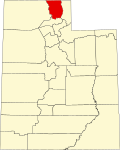
Cache County Utah incorporated and unincorporated areas Cove highlighted.svg
Location in Cache County and the state of Utah
Coordinates: 41°57′33″N111°47′34″W / 41.95917°N 111.79278°W / 41.95917; -111.79278
Country United States
State Utah
County Cache
Settled1863
Founded byGoudy Hogan
Area
  Total14.6 sq mi (37.8 km2)
  Land14.6 sq mi (37.8 km2)
  Water0.0 sq mi (0.0 km2)
Elevation
[1]
4,557 ft (1,389 m)
Population
 (2020)
  Total494
  Density32/sq mi (12.2/km2)
Time zone UTC-7 (Mountain (MST))
  Summer (DST) UTC-6 (MDT)
ZIP code
84320
Area code 435
FIPS code 49-16490 [2]
GNIS feature ID1440063 [1]

Cove is a census-designated place (CDP) in Cache County, Utah, United States. The population was 494 at the 2020 census. [3] It is included in the Logan, Utah-Idaho Metropolitan Statistical Area.

Contents

Geography

According to the United States Census Bureau, the CDP has a total area of 14.6 square miles (37.8 km2), all land. [3]

Demographics

Historical population
CensusPop.Note
2000 443
2010 4603.8%
2020 4947.4%

At the 2000 census there were 433 people, 116 households, and 103 families in the CDP. The population density was 29.5 inhabitants per square mile (11.4/km2). There were 123 housing units at an average density of 8.2/sq mi (3.2/km2). The racial makeup of the CDP was 92.33% White, 0.23% Native American, 0.45% Asian, 3.39% from other races, and 3.61% from two or more races. Hispanic or Latino of any race were 3.39%. [2]

Of the 116 households 57.8% had children under the age of 18 living with them, 85.3% were married couples living together, 0.9% had a female householder with no husband present, and 11.2% were non-families. 10.3% of households were one person and 7.8% were one person aged 65 or older. The average household size was 3.82 and the average family size was 4.15.

The age distribution was 43.6% under the age of 18, 8.1% from 18 to 24, 24.8% from 25 to 44, 14.7% from 45 to 64, and 8.8% 65 or older. The median age was 21 years. For every 100 females, there were 89.3 males. For every 100 females age 18 and over, there were 100.0 males.

The median household income was $50,667 and the median family income was $51,083. Males had a median income of $43,000 versus $31,250 for females. The per capita income for the CDP was $12,316. About 9.5% of families and 15.6% of the population were below the poverty line, including 24.1% of those under age 18 and none of those age 65 or over.

See also

Related Research Articles

<span class="mw-page-title-main">East Hemet, California</span> Census-designated place in California, United States

East Hemet is a census-designated place (CDP) in Riverside County, California, United States, located east of Hemet. East Hemet is in an unincorporated area outside the city limits of Hemet. The population was 17,418 at the 2010 census, up from 14,823 at the 2000 census.

<span class="mw-page-title-main">Big River, California</span> Census-designated place in California, United States

Big River is a census-designated place (CDP) in San Bernardino County, California, United States. The population was 1,084 at the 2020 census, down from 1,327 at the 2010 census.

<span class="mw-page-title-main">Winter Gardens, California</span> Census-designated place in California, United States

Winter Gardens is a census-designated place (CDP) in San Diego County, California. The population was 20,631 at the 2010 census, up from 19,771 at the 2000 census.

<span class="mw-page-title-main">Lemon Cove, California</span> Census designated place in California, United States

Lemon Cove is a census-designated place (CDP) in the San Joaquin Valley in Tulare County, California, United States. The population was 308 at the 2010 census, up from 298 at the 2000 census.

<span class="mw-page-title-main">Zephyr Cove–Round Hill Village, Nevada</span> Former CDP in Nevada, United States

Zephyr Cove–Round Hill Village is a former census-designated place (CDP) in Douglas County, Nevada, United States. The population was 1,649 at the 2000 census. For the 2010 census, the area was split into the Zephyr Cove and Round Hill Village CDPs.

<span class="mw-page-title-main">Glen Head, New York</span> Hamlet and census-designated place in New York, United States

Glen Head is a hamlet and census-designated place (CDP) located within the Town of Oyster Bay in Nassau County, on the North Shore of Long Island, in New York, United States. It is considered part of the greater Glen Cove area, which is anchored by the City of Glen Cove. The population was 4,837 at the 2020 census.

Short is a census-designated place (CDP) in Sequoyah County, Oklahoma, United States. It is part of the Fort Smith, Arkansas-Oklahoma Metropolitan Statistical Area. The population was 328 at the 2000 census.

<span class="mw-page-title-main">Riverside, Utah</span> CDP in Utah, United States

Riverside is a census-designated place (CDP) in Box Elder County, Utah, United States. The population was 760 at the 2010 census.

<span class="mw-page-title-main">South Willard, Utah</span> CDP in Utah, United States

South Willard is a census-designated place (CDP) in Box Elder County, Utah, United States. The population was 1,571 at the 2010 census.

<span class="mw-page-title-main">Cache, Utah</span> CDP in Utah, United States

Cache Junction is a census-designated place (CDP) in Cache County, Utah, United States. The population was 38 at the 2010 census. It is included in the Logan, Utah-Idaho (partial) Metropolitan Statistical Area.

<span class="mw-page-title-main">Mount Olympus, Utah</span> Former CDP in Utah, United States

Mount Olympus or Olympus Cove is a neighborhood in Millcreek, Utah built on the northwestern slopes of Mount Olympus of the Wasatch Range. It was formerly a census-designated place (CDP), but was consolidated into the Millcreek CDP for census purposes in 2010. Millcreek incorporated as a city in 2016. The commercial center of the neighborhood is the relatively flat area south of the crossing of Mill Creek by Interstate 215, which includes the Olympus Hills Shopping Center, Skyline High School, a trailhead for non-motorized access to Mill Creek Canyon, and a Utah Transit Authority park and ride lot. As of the 2000 census, the CDP population was 7,103, a slight decrease from the 1990 figure of 7,413.

<span class="mw-page-title-main">Silver Summit, Utah</span> CDP in Utah, United States

Silver Summit is a census-designated place (CDP) in Summit County, Utah, United States. Prior to the 2010 Census, the area was designated as North Snyderville Basin CDP. The population was 1,821 at the 2000 census.

<span class="mw-page-title-main">Snyderville, Utah</span> CDP in Utah, United States

Snyderville is a census-designated place (CDP) near the southwestern edge of Summit County, Utah, United States. Prior to the 2010 Census, the area was designated as South Snyderville Basin CDP. The population was 3,636 at the 2000 census.

<span class="mw-page-title-main">Woodland, Utah</span> CDP in Utah, United States

Woodland is a census-designated place (CDP) in Summit County, Utah, United States. The population was 335 at the 2000 census.

<span class="mw-page-title-main">Randlett, Utah</span> CDP in Utah, United States

Randlett is a census-designated place (CDP) in west-central Uintah County, Utah, United States. In the 2000 census its population was 224, a 21% decrease from the 1990 figure of 283.

<span class="mw-page-title-main">Lake Shore, Utah</span> CDP in Utah, United States

Lake Shore is a census-designated place (CDP) in Utah County, Utah, United States. It is part of the Provo–Orem Metropolitan Statistical Area. The population was 817 at the 2010 census.

<span class="mw-page-title-main">West Mountain, Utah</span> CDP in Utah, United States

West Mountain is a census-designated place (CDP) in Utah County, Utah, United States. It is part of the Provo–Orem Metropolitan Statistical Area. As of the 2010 census, the CDP population was 1,186. The town is at the base of West Mountain and bears its name.

<span class="mw-page-title-main">Provincetown (CDP), Massachusetts</span> Census-designated place in Massachusetts, United States

Provincetown (CDP) is a census-designated place (CDP) in the town of Provincetown in Barnstable County, Massachusetts, United States. The population was 2,642 at the 2010 census, out of 2,942 in the entire town.

<span class="mw-page-title-main">Barre (CDP), Massachusetts</span> CDP in Massachusetts, United States

Barre is a census-designated place (CDP) in the town of Barre in Worcester County, Massachusetts, United States. The population was 1,009 at the 2010 census.

<span class="mw-page-title-main">Oljato–Monument Valley, Utah</span> CDP in Utah, United States

Oljato-Monument Valley is a census-designated place (CDP) in San Juan County, Utah, United States. The population was 864 at the 2000 census.

References

  1. 1 2 U.S. Geological Survey Geographic Names Information System: Cove
  2. 1 2 "U.S. Census website". United States Census Bureau . Retrieved January 31, 2008.
  3. 1 2 "Geographic Identifiers: 2010 Census Summary File 1 (G001): Cove CDP, Utah". U.S. Census Bureau, American Factfinder. Archived from the original on February 13, 2020. Retrieved August 7, 2015.

Commons-logo.svg Media related to Cove, Utah at Wikimedia Commons