Crampton's Gap

Last updated
Crampton's Gap
CramptonsGap112611Large.jpg
Crampton's Gap looking from the south side (Gathland State Park) to the north
Elevation 928 feet (283 m) [1]
Traversed byGapland Road
Location Frederick County and Washington County, Maryland, United States
Range South Mountain
Blue Ridge Mountains
Coordinates 39°25′N77°38′W / 39.41°N 77.64°W / 39.41; -77.64 [2]
USA Maryland relief location map.svg
Red pog.svg
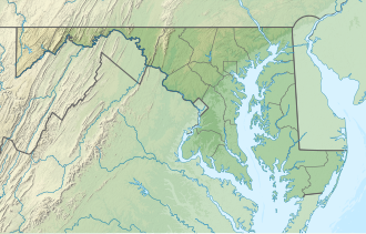
Location of the gap in Maryland

Crampton's Gap, also known as Crampton Gap, is a wind gap on South Mountain in Maryland.

The 928 feet (283 m) gap connects Burkittsville in the Middletown Valley to the east with Gapland and Rohrersville in the Pleasant Valley to the west.

Documentation of the earliest land tracts in the Crampton's Gap area and records related to the earliest road may be found in The Land Tracts of the Battlefield of South Mountain by Curtis L. Older. [3]

The gap is the location of Gathland State Park and was the site of the Battle of Crampton's Gap on September 14, 1862, during the Maryland Campaign of the American Civil War.

War Correspondents Memorial Arch and First New Jersey Brigade Monument at Crampton's Gap War Correspondents Memorial Arch and First New Jersey Brigade Monument, Crampton's Gap, MD.jpg
War Correspondents Memorial Arch and First New Jersey Brigade Monument at Crampton's Gap

Related Research Articles

<span class="mw-page-title-main">Burkittsville, Maryland</span> Town in Maryland, United States

Burkittsville is a historic village in Frederick County, Maryland, United States. The village lies in the southern Middletown Valley along the eastern base of South Mountain.

<span class="mw-page-title-main">Sharpsburg, Maryland</span> Town in Maryland, United States

Sharpsburg is a town in Washington County, Maryland. The town is approximately 13 miles (21 km) south of Hagerstown. Its population was 705 at the 2010 census.

<span class="mw-page-title-main">Battle of South Mountain</span> Battle of the American Civil War

The Battle of South Mountain—known in several early Southern accounts as the Battle of Boonsboro Gap—was fought on September 14, 1862, as part of the Maryland campaign of the American Civil War. Three pitched battles were fought for possession of three South Mountain passes: Crampton's, Turner's, and Fox's Gaps. Maj. Gen. George B. McClellan, commanding the Union Army of the Potomac, needed to pass through these gaps in his pursuit of Confederate General Robert E. Lee's precariously divided Army of Northern Virginia. Although the delay bought at South Mountain would allow him to reunite his army and forestall defeat in detail, Lee considered termination of the Maryland Campaign at nightfall.

<span class="mw-page-title-main">Maryland campaign</span> 1862 invasion of Northern United States

The Maryland campaign occurred September 4–20, 1862, during the American Civil War. Confederate Gen. Robert E. Lee's first invasion of the North was repulsed by the Army of the Potomac under Maj. Gen. George B. McClellan, who moved to intercept Lee and his Army of Northern Virginia and eventually attacked it near Sharpsburg, Maryland. The resulting Battle of Antietam was the bloodiest single-day battle in American history.

The Potomac Highlands of West Virginia centers on five West Virginian counties in the upper Potomac River watershed in the western portion of the state's Eastern Panhandle, bordering Maryland and Virginia. Because of geographical proximity, similar topography and landscapes, and shared culture and history, the Potomac Highlands region also includes Pocahontas, Randolph, and Tucker counties, even though they are in the Monongahela River or New River watersheds and not that of the Potomac River.

<span class="mw-page-title-main">Turner's Gap</span> Wind gap in Maryland, United States

Turner's Gap is a wind gap in the South Mountain Range of the Blue Ridge Mountains, located in Frederick County and Washington County, Maryland. The gap is traversed by U.S. Route 40 Alternate, the old National Pike. The Appalachian Trail also crosses the gap along the ridgeline.

The Battle of Crampton's Gap, or Battle of Burkittsville, was a battle fought between forces under Confederate Brig. Gen. Howell Cobb and Union Maj. Gen. William B. Franklin as part of the Battle of South Mountain on September 14, 1862, at Crampton's Gap in Western Maryland, during the Maryland Campaign of the American Civil War.

<span class="mw-page-title-main">Caledonia State Park</span> State park in Pennsylvania, United States

Caledonia State Park is a 1,125-acre (455 ha) Pennsylvania state park in Greene Township, Franklin County and Franklin Township, Adams County in southern Pennsylvania.

<span class="mw-page-title-main">South Mountain (Maryland and Pennsylvania)</span> Mountain in Maryland and Pennsylvania, United States

South Mountain is the northern extension of the Blue Ridge Mountain range in Maryland and Pennsylvania. From the Potomac River near Knoxville, Maryland in the south to Dillsburg, Pennsylvania in York County, Pennsylvania in the north, the 70-mile-long (110 km) range separates the Hagerstown and Cumberland valleys from the Piedmont regions of the two states.

<span class="mw-page-title-main">Gambrill State Park</span> State park in Maryland, United States

Gambrill State Park is a public recreation area located on Catoctin Mountain near the city of Frederick in Frederick County, Maryland. The state park is known for the dramatic views of the surrounding area that can be seen from stone overlooks built in the 1930s by the Civilian Conservation Corps. The park is operated by the Maryland Department of Natural Resources.

<span class="mw-page-title-main">Mont Alto State Park</span>

Mont Alto State Park is a Pennsylvania state park on 24 acres (9.7 ha) in Quincy Township, Franklin County, Pennsylvania in the United States. The park is on Pennsylvania Route 233 one mile from Mont Alto.

<span class="mw-page-title-main">Gathland State Park</span> State park in Maryland, United States

Gathland State Park is a public recreation area and historic preserve located on South Mountain near Burkittsville, Maryland, in the United States. The state park occupies the former estate of war correspondent George Alfred Townsend (1841-1914), who wrote under the pen name "Gath" during the American Civil War. The estate's few remaining original structures include the War Correspondents Memorial Arch, which sits alongside the Appalachian Trail. The park is operated by the Maryland Department of Natural Resources. The arch is a National Historic Monument maintained by the National Park Service.

<span class="mw-page-title-main">Maryland Route 67</span> State highway in Washington County, Maryland, US, known as Rohrersville Rd

Maryland Route 67 is a state highway in the U.S. state of Maryland. Known as Rohrersville Road, the state highway runs 12.20 miles (19.63 km) from U.S. Route 340 in Weverton north to US 40 Alternate in Boonsboro. MD 67 parallels the western flank of South Mountain in southeastern Washington County, connecting Boonsboro with Weverton and Rohrersville. In conjunction with US 340 and US 40 Alternate, MD 67 connects Hagerstown and Harpers Ferry, West Virginia, a link that made the highway one of the original state roads marked for improvement in 1909. The first section of the state highway was constructed through Rohrersville around 1920. The remainder of the highway was built between Boonsboro and Weverton in the late 1920s and early 1930s. MD 67 was reconstructed with multiple relocations starting in the late 1950s, culminating in a relocation at the southern terminus to tie into the US 340 freeway in the late 1960s.

<span class="mw-page-title-main">South Mountain State Park</span> State park in Maryland, United States

South Mountain State Park is a public recreation area that runs for nearly the entire length of South Mountain through Washington and Frederick counties in Maryland. The state park is contiguous with several other national, state and local parks on the mountain, including the Chesapeake and Ohio Canal National Historical Park, Gathland State Park, Washington Monument State Park, Greenbrier State Park and Pen Mar County Park.

<span class="mw-page-title-main">Fox's Gap</span> Wind gap in Blue Ridge Mountains

Fox's Gap, also known as Fox Gap, is a wind gap in the South Mountain Range of the Blue Ridge Mountains, located in Frederick County and Washington County, Maryland. The gap is traversed by Reno Monument Road. The Appalachian Trail also crosses the gap along the ridgeline.

Park Hall is an unincorporated community in Washington County, Maryland, United States. Park Hall is located 3.5 miles (5.6 km) southeast of Keedysville.

<span class="mw-page-title-main">Crampton's Gap Historic District</span> Historic district in Maryland, United States

The Crampton's Gap Historic District comprises the battlefield where the American Civil War Battle of Crampton's Gap, part of the larger Battle of South Mountain, took place on September 14, 1862. The district extends on the west to the foot of South Mountain, and to the east of Burkittsville, beyond the eastern foot of the mountain. The district is characterized by steep mountain terrain in the west and open farmland in the east, with the small town of Burkittsville in the center, which is itself listed as a historic district on the National Register of Historic Places. The district extends to the south to include Brownsville Gap. The district includes 98 contributing buildings, 78 of which are in the Burkittsville Historic District. Crampton's Gap at the crest of the mountain is encompassed by Gathland State Park, which features the War Correspondents Memorial Arch, erected in 1896 to memorialize journalists killed in wartime. The arch is listed on the National Register as part of Antietam National Battlefield. The mountainous portions of the district feature numerous stone walls, which were used by both sides for shelter against gunfire during the battle.

<span class="mw-page-title-main">Turner's and Fox's Gaps Historic District</span> Historic district in Maryland, United States

The Turner's and Fox's Gaps Historic District comprises the Civil War-era battlefield involved in the Battle of South Mountain, which took place on September 14, 1862. The district extends on the west to the slopes of South Mountain in the area of Zittlestown, and to the east beyond the foot of the mountain to the small community of Bolivar. The district is characterized by steep mountain terrain in the west and open farmland in the east, with Turner's Gap to the north and Fox's Gap to the south. The district includes 115 contributing buildings and structures. The most significant contributing buildings are the Mountain House Inn and the White House Inn, or Beachley House. Also included in the list is the Reno Monument at Fox's Gap, shown at right. The Old National Pike, now known as U.S. 40 Alternate, passes over South Mountain at Turner's Gap.

<span class="mw-page-title-main">McPherson Ridge</span>

McPherson Ridge is a landform used for military engagements during the 1863 Battle of Gettysburg, when the I Corps of the Union Army had a headquarters on the ridge and was defeated by the Confederate division of Major General Henry Heth. The ridge has terrain above ~530 ft (160 m) and is almost entirely a federally protected area except for township portions at the southern end and along Pennsylvania Route 116, including a PennDOT facility. The northern end is a slight topographic saddle point on the west edge of Oak Ridge, and summit areas above 560 ft (170 m) include 4 on/near the Lincoln Highway, a broader summit south of the Fairfield Road, and the larger plateau at the northern saddle.

<span class="mw-page-title-main">National War Correspondents Memorial</span> Memorial in Maryland, United States

The National War Correspondents Memorial, part of Gathland State Park, is a memorial dedicated to journalists who died in war. It is located at Crampton's Gap at South Mountain, near Burkittsville, Maryland, in the United States.

References

  1. National Elevation Dataset
  2. GNIS
  3. Older, Curtis L., The Land Tracts of the Battlefield of South Mountain, Heritage Books, Inc., ISBN 1-58549-066-0.