Csongrád County

Last updated • 4 min readFrom Wikipedia, The Free Encyclopedia

Csongrád County

Csongrád megye
Maros river embankment, near to Mako - causeway.jpg
Opusztaszer Rotunda.JPG
Cathedral of Szeged2.jpg
Descending, from top: Maros river embankment near Makó, Ópusztaszer National Heritage Park, and Cathedral of Szeged
FLAG-Csongrad-megye.svg
Flag
HU Csongrad megye COA.svg
Coat of arms
HU county Csongrad.svg
Csongrád County within Hungary
Country Flag of Hungary.svg  Hungary
Region Southern Great Plain
County seat Szeged
Districts
Government
  President of the General AssemblyBéla Kakas (Fidesz-KDNP)
Area
  Total4,262.71 km2 (1,645.84 sq mi)
Area rank 12th in Hungary
Population
 (2015)
  Total406,205 [1]
  Rank 8th in Hungary
Postal code
66xx – 69xx
Area code(s) (+36) 62, 63
ISO 3166 code HU-CS
Website www.csongrad-megye.hu

Csongrád (Hungarian : Csongrád megye [ˈt͡ʃoŋɡraːd] ), set to be renamed Csongrád-Csanád from 2020 [2] is the name of an administrative county (comitatus or megye) in southern Hungary, straddling the river Tisza, on the border with Serbia and Romania. It shares borders with the Hungarian counties Bács-Kiskun, Jász-Nagykun-Szolnok and Békés. The administrative centre of Csongrád county is Szeged. The county is also part of the Danube-Kris-Mures-Tisa euroregion.

Contents

History

On October 3, 2017, the Hungarian Parliament passed a resolution to rename Csongrád County to Csongrád-Csanád, which will take effect on June 4, 2020. [3] The resolution was submitted by János Lázár, then-Minister of the Prime Minister's Office, who called the renaming symbolic as more than a dozen settlements in the area still share Csanád County's identity. [4]

Geography

This county has a total area of 4,263 km2 (1,646 sq mi) – 4,58% of Hungary.

The area of Csongrád County is flat. It has a high number of sunshine hours and excellent soil, which makes it the most important agricultural area of Hungary. Its most famous products are paprika from Szeged and onions from Makó, but grain, vegetables, and fruits are also significant. Half of the onions, paprika, and vegetables produced in Hungary are from Csongrád. The county is also rich in oil and natural gas.

The highest point is Ásotthalom (125 m), the lowest is Gyálarét (78 m; lowest point of Hungary).

Neighbours

Demographics

Religion in Csongrád County (2011 census)

   Catholic Church (39.4%)
   Greek Catholicism (0.4%)
   Calvinism (7.0%)
   Lutheranism (0.8%)
   Orthodoxy (0.2%)
   Judaism (0.1%)
  Other religions (1.7%)
   Non-religious (21.8%)
   Atheists (1.6%)
  Undeclared (27.0%)

After the end of the Ottoman occupation in 1715, the county was nearly uninhabited, with a population density of less than 5/km2. In the 18th and 19th centuries, the county was repopulated by ethnic Hungarians from the relatively overpopulated northern and western counties of the Kingdom of Hungary. [5] According to the 2001 census, the county is home for 423,826 people (216,936 people live in urban counties) with a population density is 100/km2. It has a Hungarian majority. [6]

In 2015, it had a population of 406,205 and the population density was 95/km².

YearCounty population [7] Change
1949429,083n/a
1960Increase2.svg 434,0461.16%
1970Increase2.svg 445,2202.57%
1980Increase2.svg 456,300 (record)2.49%
1990Decrease2.svg 438,842-3.83%
2001Decrease2.svg 433,344-1.25%
2011Decrease2.svg 417,456-3.67%

Ethnicity

Besides the Hungarian majority, the main minorities are the Roma (approx. 5,000), Romanian (1,500), German (1,300) and Serb (1,300).

Total population (2011 census): 417,456
Ethnic groups (2011 census): [8] Identified themselves: 367,193 persons:

  • Hungarians: 355,554 (96.83%)
  • Gypsies: 4,720 (1.29%)
  • Others and indefinable: 6,919 (1.88%)

Approximately 59,000 persons in Csongrád County did not declare their ethnic group on the 2011 census.

Religion

Religious adherence in the county according to the 2011 census: [9]

Regional structure

District of Csongrad County Csongrad districts.png
District of Csongrád County
English and
Hungarian names
Area
(km²)
Population
(2011)
Density
(pop./km²)
Seat№ of
municipalities
1 Csongrád District
Csongrádi járás
339.2422,99668 Csongrád (town)4
2 Hódmezővásárhely District
Hódmezővásárhelyi járás
707.7756,56080 Hódmezővásárhely 4
3 Kistelek District
Kisteleki járás
410.2018,18544 Kistelek 6
4 Makó District
Makói járás
688.8545,13866 Makó 15
5 Mórahalom District
Mórahalmi járás
561.7128,98652 Mórahalom 10
6 Szeged District
Szegedi járás
741.10204,263276 Szeged 13
7 Szentes District
Szentesi járás
813.8441,32851 Szentes 8
Csongrád County4,262.71417,45698 Szeged 60

Transport

Road network

M5 motorway near Roszke. E75 Roszke.JPG
M5 motorway near Röszke.
Main road 45 near Szentes. Szentes Attila ut kerekparut 2012-12-31.JPG
Main road 45 near Szentes.

In 2012, Csongrád County has a dense network of public roads, in total length of 1,350 km, of which 281 km are main roads. [10] Inland, connections are provided by 1,049 km of county and communal roads and 20 km are covered with light road surfaces.

Highway network
Road network

Politics

The Csongrád County Council, elected at the 2019 local government elections, is made up of 20 counselors [11] , with the following party composition:

PartySeatsCurrent County Assembly
  Fidesz-KDNP 12            
  Hungarian Socialist Party 2            
  Jobbik 2            
  Our Homeland Movement 2            
  Democratic Coalition 1            
  Momentum Movement 1            

Presidents of the General Assembly

List of Presidents, from 1990 [12]
István Lehmann (MSZP)1990–1998
Dr. József Frank (Fidesz)1998–2006
Anna Magyar (Fidesz-KDNP)2006–2014
Béla Kakas (Fidesz-KDNP)2014–

Municipalities

Csongrád County has 2 urban counties, 8 towns, 7 large villages and 43 villages.

As a typical Great Plain county, Csongrád has a relatively small number of municipalities. 72.5% of the population lives in cities/towns, so it is one of the most urbanized county in Hungary. [13]

Cities with county rights

(ordered by population, as of 2011 census)

Towns
Villages

Red pog.svg municipalities are large villages.

Related Research Articles

Szeged City with county rights in Southern Great Plain, Hungary

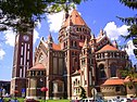
Szeged is the third largest city of Hungary, the largest city and regional centre of the Southern Great Plain and the county seat of Csongrád county. The University of Szeged is one of the most distinguished universities in Hungary.

Makó Town in Csongrád, Hungary

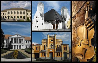
Makó is a town in Csongrád County, in southeastern Hungary, 10 km (6 mi) from the Romanian border. It lies on the Mureș River. Makó is home to 23,272 people and it has an area of 229.23 square kilometres, of which 196.8 km2 (76.0 sq mi) is arable land. Makó is the fourth-largest town in Csongrád County after Szeged, Hódmezővásárhely and Szentes. The town is 28.6 km (17.8 mi) from Hódmezővásárhely, 36.2 km (22.5 mi) from Szeged, 75.4 km (46.9 mi) from Arad, 85 km (52.8 mi) from Gyula, 93.5 km (58.1 mi) from Timișoara (Temesvár), and 200 km (124 mi) from Budapest.

Jász-Nagykun-Szolnok County (former) county of the Kingdom of Hungary

Jász-Nagykun-Szolnok was an administrative county (comitatus) in the Kingdom of Hungary. Its territory, which is now in central Hungary, was slightly smaller than that of present Jász-Nagykun-Szolnok county. The capital of the county was Szolnok.

Csanád County county of the Kingdom of Hungary

Csanád was an administrative county (comitatus) of the Kingdom of Hungary. Its territory is now part of Hungary, except a small area which is part of Romania. The capital of the county was Makó.

Torontál County Historical county in the Kingdom of Hungary

Torontál was an administrative county (comitatus) of the Kingdom of Hungary. Its territory is now divided between Serbia and Romania, except a small area which is part of Hungary. The capital of the county was Nagybecskerek, the current Zrenjanin.

Csongrád County (former) county of the Kingdom of Hungary

Csongrád was an administrative county (comitatus) of the Kingdom of Hungary. Its territory, which was smaller than that of present-day Csongrád county, is now part of Hungary, except a very small area which belongs to Serbia. The capital of the county was Szentes.

Jász-Nagykun-Szolnok County County of Hungary

Jász-Nagykun-Szolnok is the name of an administrative county in Hungary. It lies in central Hungary and shares borders with the Hungarian counties Pest, Heves, Borsod-Abaúj-Zemplén, Hajdú-Bihar, Békés, Csongrád, and Bács-Kiskun. The rivers Tisza and Körös flow through the county. The capital of Jász-Nagykun-Szolnok county is Szolnok. Its area is 5582 km². The county is named after the Ossetians (Jasz) and Cumans (Kun) who settled there, along with Szolnok. The county was part of the Danube–Criș–Mureș–Tisa Euroregion between 1997 and 2004.

Csanádpalota Town in Csongrád, Hungary

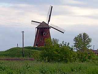
Csanádpalota is a town in the Makó-region of Csongrád county, in Hungary's Southern Great Plain.

M43 motorway (Hungary) road in Hungary

The M43 motorway is a Hungarian motorway that runs from the junction with the M5 Motorway west of Szeged to the Romanian border at Nagylak via Makó. Since 2015 it connects Hungary with Romania as the first border crossing on a motorway between the two countries.

Kunszentmárton District Districts of Hungary in Jász-Nagykun-Szolnok

Kunszentmárton is a district in southern part of Jász-Nagykun-Szolnok County. Kunszentmárton is also the name of the town where the district seat is found. The district is located in the Northern Great Plain Statistical Region. This district is a part of Nagykunság historical and geographical region.

Csongrád District Districts of Hungary in Csongrád

Csongrád is a district in north-western part of Csongrád County. Csongrád is also the name of the town where the district seat is found. The district is located in the Southern Great Plain Statistical Region.

Hódmezővásárhely District Districts of Hungary in Csongrád

Hódmezővásárhely is a district in eastern part of Csongrád County. Hódmezővásárhely is also the name of the town where the district seat is found. The district is located in the Southern Great Plain Statistical Region.

Kistelek District Districts of Hungary in Csongrád

Kistelek is a district in western part of Csongrád County. Kistelek is also the name of the town where the district seat is found. The district is located in the Southern Great Plain Statistical Region.

Szentes District Districts of Hungary in Csongrád

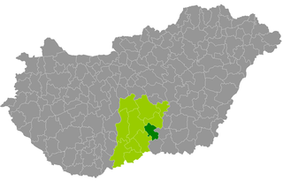
Szentes is a district in north-eastern part of Csongrád County. Szentes is also the name of the town where the district seat is found. The district is located in the Southern Great Plain Statistical Region.

Makó District Districts of Hungary in Csongrád

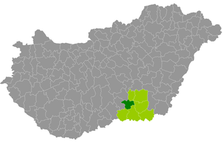
Makó is a district in south-eastern part of Csongrád County. Makó is also the name of the town where the district seat is found. The district is located in the Southern Great Plain Statistical Region.

Mórahalom District Districts of Hungary in Csongrád

Mórahalom is a district in south-western part of Csongrád County. Mórahalom is also the name of the town where the district seat is found. The district is located in the Southern Great Plain Statistical Region.

Szeged District Districts of Hungary in Csongrád

Szeged is a district in southern part of Csongrád County. Szeged is also the name of the town where the district seat is found. The district is located in the Southern Great Plain Statistical Region.

Kiskunmajsa District Districts of Hungary in Bács-Kiskun

Kiskunmajsa is a district in eastern part of Bács-Kiskun County. Kiskunmajsa is also the name of the town where the district seat is found. The district is located in the Southern Great Plain Statistical Region.

Orosháza District Districts of Hungary in Békés

Orosháza is a district in south-western part of Békés County. Orosháza is also the name of the town where the district seat is found. The district is located in the Southern Great Plain Statistical Region.

References

  1. nepesseg.com, population data of Hungarians settlements
  2. Csongrád-Csanád lesz a megye neve 2020-tól
  3. Harmat Árpád, Péter (October 5, 2017). "Csongrád - Csanád megye, az új elnevezés védelmében" . Retrieved April 4, 2020.
  4. "Új neve van Csongrád megyének". HVG. October 3, 2017. Retrieved April 7, 2020.
  5. Changing ethnicities in Hungary (map+data+assay) (Károly Kocsis, Zsolt Bottlik, MTA Földrajztudományi Kutatóintézet, Budapest 2009, ISBN   978-963-9545-18-2, ISBN   978-963-9545-19-9)
  6. Csongrád county (2001 census), English
  7. népesség.com, "Csongrád megye népessége 1870-2015"
  8. 1.1.6. A népesség anyanyelv, nemzetiség és nemek szerint – Frissítve: 2013.04.17.; Hungarian Central Statistical Office (in Hungarian)
  9. 2011. ÉVI NÉPSZÁMLÁLÁS, 3. Területi adatok, 3.6 Csongrád megye, (in Hungarian)
  10. "Csongrád Megyei Terület fejlesztési Koncepció" (PDF) (in Hungarian).Cite journal requires |journal= (help)
  11. "Megyei közgyűlés tagjai 2019-2024 (Csongrád megye)". valasztas.hu. Retrieved 2019-10-29.
  12. Önkormányzati választások eredményei (in Hungarian)
  13. List of localities in Csongrád county by area, population and status (2001 census), English

Coordinates: 46°25′N20°15′E / 46.417°N 20.250°E / 46.417; 20.250