Related Research Articles

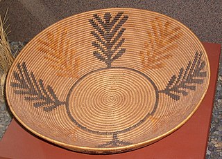
The Kumeyaay, also known as Tipai-Ipai or by their historical Spanish name Diegueño, is a tribe of Indigenous peoples of the Americas who live at the northern border of Baja California in Mexico and the southern border of California in the United States. Their Kumeyaay language belongs to the Yuman–Cochimí language family.
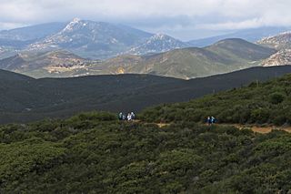
Cuyamaca is a region of eastern San Diego County. It lies east of the Capitan Grande Indian Reservation in the western Laguna Mountains, north of Descanso and south of Julian. Named for the 1845 Rancho Cuyamaca Mexican land grant, the region is now dominated by the 26,000-acre (110 km2) Cuyamaca Rancho State Park. Within the park is the prominent Cuyamaca Peak, the second-highest mountain in San Diego County at 6,512 feet (1,984.9 m).

Cuyamaca Rancho State Park is a state park in Southern California, United States, located 40 miles (64 km) east of San Diego in the Cuyamaca and Laguna Mountains of the Peninsular Ranges. The park's 26,000 acres (11,000 ha) feature pine, fir, and oak forests, with meadows and streams that exist due to the relatively high elevation of the area compared to its surroundings. The park includes 6,512-foot (1,985 m) Cuyamaca Peak, the second-highest point in San Diego County.
The San Dieguito complex is an archaeological pattern left by early Holocene inhabitants of Southern California and surrounding portions of the Southwestern United States and northwestern Mexico. Radiocarbon dating places a 10,200 BP (8200 BCE) date consideration.

Rancho Bernardo is a master-planned community in the northern hills of the city of San Diego, California.
Cuyamaca College is a public community college in Rancho San Diego, California. It is part of the Grossmont-Cuyamaca Community College District and the California Community Colleges System. Along with Grossmont College, it serves the eastern suburbs in the San Diego area. Cuyamaca College opened in 1978 and now offers 81 associate's degree programs and 66 training certification programs to approximately 8,500 students. Many of the college's students transfer to the University of California, San Diego or San Diego State University to complete their bachelor's degrees. Cuyamaca's mascot is the coyote.
This article refers to the archaeologist. For others with the name Malcolm Rogers, please see Malcolm Rogers (disambiguation).
The archaeological La Jolla complex represents a prehistoric culture oriented toward coastal resources that prevailed during the middle Holocene period between c. 8000 BC and AD 500 in southwestern California and northwestern Baja California.
The San Luis Rey Complex is an archaeological pattern representing the latest phase of prehistory in the region occupied at the time of European contact by the Luiseño Indians. Studies by Clement W. Meighan and Delbert L. True in northern San Diego County, California, defined the complex, which is also represented in adjacent portions of Riverside and Orange counties.
D. L. True was an archaeologist who worked in California, particularly San Diego County, and in northern Chile.

The Paipai are an indigenous people of Mexico living in northern Baja California. Their traditional territory lies between the Kiliwa on the south and the Kumeyaay and Cocopa on the north, and extending from San Vicente near the Pacific coast nearly to the Colorado River's delta in the east. Today they are concentrated primarily at the multi-ethnic community of Santa Catarina in Baja California's Sierra de Juárez.
San Pasqual Valley, historically spelt as San Pascual, is the northernmost community of the city of San Diego. It is named for the Kumeyaay village of San Pasqual that was once located there. It is bordered on the north by the city of Escondido, on the east and west by unincorporated land within San Diego County, and on the south by the city of Poway and the community of Rancho Bernardo. San Pasqual Valley is home to the San Diego Zoo Safari Park.
Kumeyaay (Kumiai), also known as Central Diegueño, Kamia, and Campo, is the Native American language spoken by the Kumeyaay people of southern San Diego and Imperial counties in California. Hinton (1994:28) suggested a conservative estimate of 50 native speakers of Kumeyaay. A more liberal estimate, supported by the results of the Census 2000, is 110 people in the US, including 15 persons under the age of 18. There were 377 speakers reported in the 2010 Mexican census, including 88 who called their language "Cochimi".
Tiipay (Tipay) is a Native American language spoken by a number of Kumeyaay (Kumiay) tribes in northern Baja California and southern San Diego County, California. It is also known as Southern Diegueño. Hinton (1994:28) provided a "conservative estimate" of 200 Tipai speakers in the early 1990s; the number of speakers has declined steadily since that time.
The Cuyamaca Mountains, locally the Cuyamacas, are a mountain range of the Peninsular Ranges System, in San Diego County, southern California. The mountain range runs roughly northwest to southeast. The Laguna Mountains are directly adjacent to the east, with Palomar Mountain and Hot Springs Mountain more distant to the north.

The Inaja Band of Diegueño Mission Indians of the Inaja and Cosmit Reservation is a federally recognized tribe of Kumeyaay Indians, who are sometimes known as Mission Indians.
El Vallecito is an archaeological site located in the city of La Rumorosa, in the Tecate Municipality, Baja California, Mexico.
The Regions of the San Diego metropolitan area and San Diego County, as they cover the same area are:

Vallecito, in San Diego County, California is an oasis of cienegas and salt grass along Vallecito Creek and a former settlement on the edge of the Colorado Desert in the Vallecito Valley. Its Spanish name is translated as "little valley". Vallecito was located at the apex of the gap in the Carrizo Badlands created by Carrizo Creek and its wash in its lower reach, to which Vallecito Creek is a tributary. The springs of Vallecito, like many in the vicinity, are a product of the faults that run along the base of the Peninsular Ranges to the west.
Kumeyaay Community College is a public community college in the U.S. state of California. Established in 2004 by the Sycuan Band of the Kumeyaay Nation through gaming revenues, it is located on the Sycuan Indian Reservation near El Cajon.
References
- True, D. L. 1970. Investigations of a Late Prehistoric Complex in Cuyamaca Rancho State Park, San Diego County, California. Archaeological Survey Monograph. University of California, Los Angeles.
