Cyclone Haruna

Last updated

Map key
  Tropical depression (≤38 mph, ≤62 km/h)
  Tropical storm (39–73 mph, 63–118 km/h)
  Category 1 (74–95 mph, 119–153 km/h)
  Category 2 (96–110 mph, 154–177 km/h)
  Category 3 (111–129 mph, 178–208 km/h)
  Category 4 (130–156 mph, 209–251 km/h)
  Category 5 (≥157 mph, ≥252 km/h)
  Unknown
Storm type
Disc Plain black.svg Tropical cyclone
Solid black.svg Subtropical cyclone
ArrowUp.svg Extratropical cyclone, remnant low, tropical disturbance, or monsoon depression

In the middle of February, an area of convection, or thunderstorms, persisted in the Mozambique channel. It had an associated circulation and rainbands to the east of the center, [2] and was related to the monsoon trough. [3] The system was located within an area of warm sea surface temperatures of over 29 °C (84 °F) and steadily decreasing wind shear. A ridge to the south caused the system to initially track to the north. [2] By February 16, the system had moved over Mozambique and turned to the east, although by that time it had become better organized with the convection wrapping into the center. [4] Subsequently, the system moved southward due to a weakness in the ridge, with conditions favorable for tropical cyclogenesis such as low wind shear and good divergence. [5] On February 18, the Joint Typhoon Warning Center (JTWC) issued a Tropical Cyclone Formation Alert, [6] and at 1200  UTC that day, Météo-France (MFR) initiated advisories on Tropical Disturbance 09. [7]

Upon being classified, the disturbance had a broad circulation that was difficult to locate, with moderate convection in its eastern periphery. [7] The thunderstorms organized further, and MFR upgraded the disturbance to a tropical depression at 0000 UTC on February 19. [8] Three hours later, the JTWC began issuing advisories on Tropical Cyclone 16S, [9] and at 0600 UTC that day, MFR upgraded the depression to a moderate tropical storm after an advanced scatterometer indicated winds of over 65 km/h (40 mph); as a result, the National Weather Service of Madagascar gave it the name Haruna. By that time, the circulation had become better organized with increased rainbands, [10] and with an anticyclone aloft, the storm developed well-defined outflow. [11] The structure of Haruna continued to become more symmetrical with a large radius of maximum winds, developing a ragged eye early on February 20. Based on the improved appearance, MFR upgraded Haruna to a severe tropical storm at 0000 UTC that day. [12] About 12 hours later, the agency upgraded Haruna further to tropical cyclone status, with 10 minute winds of 120 km/h (75 mph). [13] That day, an approaching trough weakened the ridge to the south, causing the cyclone to slow and move erratically. [14] While Haruna was approaching the southwestern coast of Madagascar, it developed a 120 km (75 mi) wide eye, and the eyewall passed over Europa Island. Initially, MFR estimated that the storm would intensify to intense tropical cyclone status, and the agency assessed that Haruna reached 10 minute winds of 150 km/h (95 mph) on February 20. [15] The next day, JTWC estimated peak 1 minute winds of 185 km/h (115 mph). [16] In contrast, MFR estimated at that time that the cyclone had peaked when the eyewall thunderstorms warmed, [17] followed by the eye becoming less organized and the winds decreasing. [18]

While moving slowly to the east-southeast, Haruna re-intensified early on February 22 to its previous MFR peak intensity. [19] At around 0230 UTC that day, the cyclone made landfall about 55 km (35 mi) south of Morombe in southwestern Madagascar. [20] Haruna quickly weakened below cyclone status, [20] and while over land it accelerated to the southeast. [21] On February 23, Haruna weakened to an overland depression with 10 minute winds of around 45 km/h (30 mph). [22] A few hours later, the system emerged into the Indian Ocean near Fort Dauphin as a tropical disturbance. [23] With generally favorable conditions, convection reorganized slightly and the system redeveloped outflow to the south. [24] Early on February 24, Haruna re-intensified into a moderate tropical storm, [25] although soon after it weakened again due to cooler waters, increasing shear, and dry air. [26] At 1200 UTC, MFR issued its last advisory after Haruna began losing tropical characteristics, designating it as a subtropical depression. [27] The next day, the JTWC also discontinued advisories on the storm, noting that Haruna was dissipating about 665 km (415 mi) south-southwest of Réunion. [28]

Impact and aftermath

Satellite image of Haruna over southern Madagascar on February 22 Haruna Feb 22 2013 1100Z.jpg
Satellite image of Haruna over southern Madagascar on February 22

On Europa Island in the Mozambique Channel, Haruna produced wind gusts of 144 km/h (90 mph) during the passage of the eyewall. [15] Before the cyclone struck Madagascar, the Intertropical Convergence Zone had caused flooding in the country that killed four people and caused widespread road disruption. [29] Officials prepared by collecting supplies in the capital Antananarivo beginning on February 20, and sending an emergency crew to the expected landfall location. Residents were evacuated using boats and canoes to shelters. [30]

For several days while offshore western Madagascar, Haruna dropped greater than normal rainfall. [31] The storm ultimately made landfall about 15 hours faster than anticipated. [32] Winds and rainfall from Haruna damaged houses and power systems, [33] and also damaged 265 classrooms and 16 health facilities. [34] There was also damage to the rice and maize crops from high winds near the coast, [35] causing food shortages. [36] Rains from the storm caused a dyke along the Fiherenana River to break, which flooded a large region and forced about 6,000 people to evacuate their homes. [37] The flooding from the dyke break was worst in Toliara, where most residents lost access to fresh water and power. Flooding in the city caused the temporarily closure of the airport there. [33] The town of Morombe was temporarily isolated after the road was blocked. Power outages affected Morombe, Toliara, Sakaraha, and Betioky Sud. [38] Downed trees had affected roads near Toliara but were quickly removed. [30] About 1,050 houses were flooded, another 691 lost their roofs, [33] and 7,402 were destroyed, leaving 13,882 people homeless. Overall, Haruna killed 26 people and injured another 127. [39]

There were initial difficulties in distributing aid to areas of southwestern Madagascar due to prevailing unsettled weather, [38] along with fuel shortages. [30] Workers used boats to rescue people in flooded areas. [38] Members of the Madagascar Armed Forces, along with about 200 Red Cross volunteers, assisted in evacuations and aid distribution, [40] [30] and the Red Cross also provided free medical consultations to thousands of people. [30] Following the storm, there were increased levels of malaria, dysentery, and childhood diarrhea in the area around Toliara, [34] and there was a locust outbreak. [41] Increased locust activity persisted into the summer, and had been occurring since late 2012; this caused continued food shortages, and by July the locusts were affecting about half of the country's farmlands. [42] To prevent further spreading of disease, officials provided vaccinations and sprayed insecticide. [30] In isolated villages in southwestern Madagascar, residents faced food shortages, while in some areas, the water supply was contaminated. [43] Within a few weeks of the storms, many residents whose dwellings were not destroyed were able to return to their homes. In Toliara, about 4,000 students were initially unable to return to school due to being displaced. [44] In the middle of March, 1,948 displaced people stayed in a military camp or two schools, [34] but most returned home by early April. [45] Repairs to the dyke in Toliara began in early April, and were expected to take about a month and a half. [45]

On February 23, the prime minister of Madagascar issued an appeal to the international community for assistance. [30] In Toliara, United Nations agencies, including the World Food Programme, and non-governmental organizations worked together to provide food for 3,000 people in six shelters. [30] [38] The World Food Programme sent a truck with 1,050 tons of food to Toliara, including corn and legumes. [30] A few days after Haruna struck, the French Red Cross sent a ship to Toliara with 35 tons of supplies, including for housing and water. The International Federation of Red Cross and Red Crescent Societies authorized funds to help up to 10,000 affected residents. [40] Handicap International provided food and shelter to 547 people in Toliara. [46] Action Against Hunger sent a plane with 15 tons of supplies, including water treatment units, to Madagascar after the storm. [47] By March 20, 1,330 wells were disinfected by various crews. [30] On March 1, the European Commission donated 200,000 for immediate relief. [48] The Red Crescent Society of the United Arab Emirates sent about 80 tonnes of food, medicine, and building supplies to the country. [49]

See also

Related Research Articles

<span class="mw-page-title-main">2002–03 South-West Indian Ocean cyclone season</span> Cyclone season in the South-West Indian Ocean

The 2002–03 South-West Indian Ocean cyclone season was one of the longest lasting and the third-most active season in the South-West Indian Ocean. Storms during the season impacted the Mascarene Islands, Seychelles, Madagascar, and countries in south-eastern Africa. The season began early when an unnamed tropical storm struck Seychelles in September, becoming the most damaging storm there in 50 years. The next system, Atang, was the first named storm of the season, but was only a tropical depression; it was named due to the threat to an outer island of Mauritius. Atang later struck Tanzania in a climatologically unusual area in November, resulting in unconfirmed deaths of fishermen. The first named storm to reach tropical storm intensity was Boura, which brushed the Mascarene Islands with gusty winds and rainfall. In December, Cyclone Crystal threatened to strike Mauritius but instead veered eastward, and later, Tropical Storm Delfina lasted from late December through early January 2003. Delfina damaged or destroyed thousands of houses in Mozambique and Malawi, killing 54 people.

<span class="mw-page-title-main">Cyclone Elita</span> South-West Indian cyclone in 2004

Tropical Cyclone Elita was an unusual tropical cyclone that made landfall on Madagascar three times. The fifth named storm of the 2003–04 South-West Indian Ocean cyclone season, Elita developed in the Mozambique Channel on January 24, 2004. It strengthened to tropical cyclone status before striking northwestern Madagascar on January 28; it was the first storm to strike western Madagascar at that intensity since Cyclone Cynthia in 1991. Elita weakened to tropical depression status while crossing the island, and after exiting into the southwest Indian Ocean, it turned to the west and moved ashore in eastern Madagascar on January 31. After once again crossing the island, the cyclone reached the Mozambique Channel and re-intensified. Elita turned to the southeast to make its final landfall on February 3 along southwestern Madagascar. Two days later, it underwent an extratropical transition; subsequently, the remnant system moved erratically before dissipating on February 13.

<span class="mw-page-title-main">2008–09 South-West Indian Ocean cyclone season</span> Cyclone season in the Southwest Indian Ocean

The 2008–09 South-West Indian Ocean cyclone season was a slightly above average event in tropical cyclone formation. It began on November 15, 2008, and officially ended on April 30, 2009, with the exception for Mauritius and the Seychelles, for which it ended on May 15, 2009. These dates conventionally delimit the period of each year when most tropical cyclones form in the basin, which is west of 90°E and south of the Equator. Tropical cyclones in this basin were monitored by the Regional Specialised Meteorological Centre in Réunion.

<span class="mw-page-title-main">Cyclone Bondo</span> South-West Indian cyclone in 2006

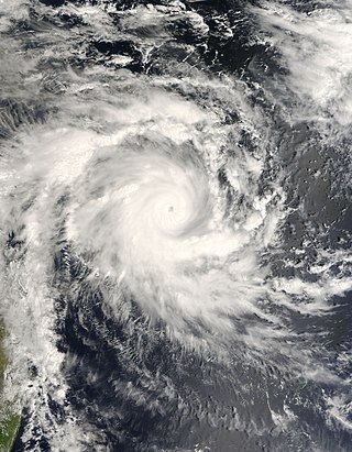
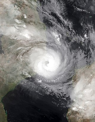
Intense Tropical Cyclone Bondo was the first of a series of six tropical cyclones to impact Madagascar during the 2006–07 South-West Indian Ocean cyclone season. Bondo developed on 15 December in the central Indian Ocean, west of Diego Garcia. After strengthening into a moderate tropical storm on 18 December, the storm rapidly intensified while moving westward, taking advantage of favorable atmospheric conditions. Within 18 hours of being named, Bondo intensified to tropical cyclone status, or the equivalent of a minimal hurricane. The Météo-France office on Réunion (MFR) estimated peak 10-minute sustained winds of 205 km/h (125 mph), although the American-based Joint Typhoon Warning Center estimated stronger 1-minute winds of 250 km/h (155 mph). While near peak intensity, Bondo passed just south of Agaléga island, before weakening slightly and moving through the Farquhar Group of islands belonging to the Seychelles, becoming the strongest cyclone to affect that island group in decades. Bondo turned southwestward, and after brushing the northern coast of Madagascar, the cyclone made landfall near Mahajanga on 25 December. The storm continued southward, and was last tracked by the MFR on 28 December.

<span class="mw-page-title-main">Cyclone Fanele</span> South-West Indian cyclone in 2009

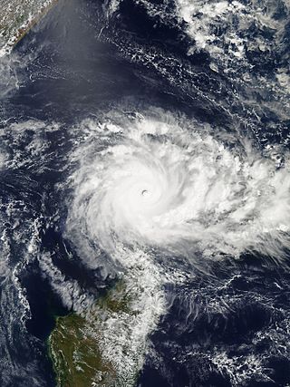
Intense Tropical Cyclone Fanele was the first tropical cyclone to strike western Madagascar since Cyclone Fame one year prior. It formed on January 18, 2009 in the Mozambique Channel, and rapidly organized as it remained nearly stationary. Fanele ultimately turned toward the southwest Madagascar coastline, reaching peak winds of 185 km/h (115 mph), according to the Réunion Météo-France office (MFR). It weakened before moving ashore in Menabe Region southwest of Morondava, and rapidly weakened over land. Fanele briefly re-intensified after reaching open waters, only to become an extratropical cyclone by January 23.

<span class="mw-page-title-main">2010–11 South-West Indian Ocean cyclone season</span> Cyclone season in the Southwest Indian Ocean

The 2010–11 South-West Indian Ocean cyclone season was the least active cyclone season on record in the basin, tied with 1982–83, producing only three systems of gale intensity. This was due to cooler than normal water temperatures and the Walker circulation – a broad atmospheric circulation – causing unusually moist conditions in the eastern Indian Ocean and unusually dry conditions in the western Indian Ocean. The basin includes the waters of the ocean south of the equator and west of 90º E to the eastern coast of Africa.

<span class="mw-page-title-main">2012–13 South-West Indian Ocean cyclone season</span> Cyclone season in the Southwest Indian Ocean

The 2012–13 South-West Indian Ocean cyclone season was a slightly above average event in tropical cyclone formation in the Southern hemisphere tropical cyclone year starting on July 1, 2012, and ending on June 30, 2013. Within this basin, tropical and subtropical disturbances are officially monitored by the Regional Specialised Meteorological Centre on Réunion island, while the Mauritius and Madagascar weather services assign names to significant tropical and subtropical disturbances. The first tropical disturbance of the season developed on October 12 and rapidly developed into the earliest known intense tropical cyclone on record during October 14.

<span class="mw-page-title-main">2014–15 South-West Indian Ocean cyclone season</span> Cyclone season in the Southwest Indian Ocean

The 2014–15 South-West Indian Ocean cyclone season was an above average event in tropical cyclone formation. It began on November 15, 2014, and ended on April 30, 2015, with the exception for Mauritius and the Seychelles, for which it ended on May 15, 2015. These dates conventionally delimit the period of each year when most tropical and subtropical cyclones form in the basin, which is west of 90°E and south of the Equator. Tropical and subtropical cyclones in this basin are monitored by the Regional Specialised Meteorological Centre in Réunion.

<span class="mw-page-title-main">Tropical Storm Delfina</span> South-West Indian tropical storm in 2002 and 2003

Severe Tropical Storm Delfina was a damaging tropical cyclone that affected southeastern Africa in January 2003. The fourth named storm of the 2002–03 South-West Indian Ocean cyclone season, Delfina formed off the northwest coast of Madagascar on December 30, 2002. It quickly intensified while moving westward, becoming a strong tropical storm before hitting northeastern Mozambique on December 31. Delfina weakened while moving inland, and it was no longer classifiable as a tropical cyclone by January 1, 2003. However, its remnants moved across the country and into Malawi, later looping around and crossing back over Mozambique; the remnants of Delfina were last observed on January 9.

<span class="mw-page-title-main">Tropical Storm Chedza</span>

Severe Tropical Storm Chedza was a deadly tropical cyclone that struck Madagascar in January 2015. It formed from the Intertropical Convergence Zone and moved over Mozambique, After moving open waters, the system began organizing on January 14, becoming Tropical Storm Chedza two days later. It quickly intensified over the Mozambique Channel due to warm waters and favorable conditions, and the storm attained peak 10 minute sustained winds of 100 km/h (60 mph) on January 16. That day, Chedza moved ashore western Madagascar between Belo sur Mer and Morondava, and it quickly crossed the island while weakening. The storm briefly re-intensified, passing southwest of Réunion before turning to the southeast. Chedza became extratropical on January 19, and was last noted two days later.

<span class="mw-page-title-main">Cyclone Fantala</span> South-West Indian Ocean cyclone in 2016

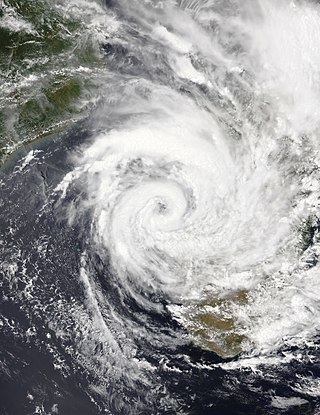
Very Intense Tropical Cyclone Fantala was the most intense tropical cyclone recorded in the South-West Indian Ocean in terms of sustained winds. Part of the 2015–16 cyclone season, Fantala formed on 11 April to the south of Diego Garcia, an island in the central Indian Ocean. With a ridge to the south, the storm moved westward for several days while gaining strength, aided by warm waters and decreasing wind shear. Late on 17 April, the Météo-France office on Réunion (MFR) estimated peak 10-minute winds of 250 km/h (155 mph), making Fantala the strongest tropical cyclone of the basin in terms of 10-minute sustained winds. The Joint Typhoon Warning Center (JTWC) estimated peak 1-minute winds of 285 km/h (180 mph), equivalent to Category 5 intensity on the Saffir-Simpson scale, also the strongest on record in the South-West Indian Ocean, in terms of maximum sustained wind speed. Early on 18 April, Fantala reached its peak intensity, with a minimum central pressure of 910 millibars (27 inHg).

<span class="mw-page-title-main">2018–19 South-West Indian Ocean cyclone season</span> Cyclone season in the Southwest Indian Ocean

The 2018–19 South-West Indian Ocean cyclone season was the costliest and the most active season ever recorded. Additionally, it is also the deadliest cyclone season recorded in the South-West Indian Ocean, surpassing the 1891–92 season in which the 1892 Mauritius cyclone devastated the island of Mauritius, and is mainly due to Cyclone Idai. The season was an event of the annual cycle of tropical cyclone and subtropical cyclone formation in the South-West Indian Ocean basin. It officially began on 15 November 2018, and ended on 30 April 2019, except for Mauritius and the Seychelles, which it ended on 15 May 2019. These dates conventionally delimit the period of each year when most tropical and subtropical cyclones form in the basin, which is west of 90°E and south of the Equator. Tropical and subtropical cyclones in this basin are monitored by the Regional Specialised Meteorological Centre in Réunion.

<span class="mw-page-title-main">Tropical Storm Eliakim</span> South-West Indian Ocean severe tropical storm in 2018

Severe Tropical Storm Eliakim was a tropical cyclone that affected Madagascar and killed 21 people in 2018. The seventh tropical depression, sixth tropical storm of the 2017–18 South-West Indian Ocean cyclone season, and fourth tropical cyclone in 2018 to impact Madagascar, Eliakim was first noted as an area of atmospheric convection south-southwest of Diego Garcia on 9 March. Developmental conditions were favorable in its vicinity, and on 14 March, both the Joint Typhoon Warning Center (JTWC) and Météo-France La Réunion (MFR) began issuing warnings on the system, with MFR designating it as Tropical Disturbance 7 and the JTWC giving it the designation 14S. On the next day, MFR upgraded the system to a moderate tropical storm, assigning it the name Eliakim. Eliakim further intensified into a severe tropical storm on 15 March, with the JTWC upgrading it to a Category 1-equivalent cyclone on the Saffir–Simpson scale on 16 March. Eliakim made landfall on Masoala at 07:00 UTC, after which MFR estimated maximum 10-minute sustained winds of 110 km/h (70 mph) within the system. Eliakim weakened into a moderate tropical storm before abruptly turning southwards and re-emerging over water on 17 March. Despite unfavorable conditions, Eliakim re-intensified into a severe tropical storm on 19 March before being downgraded back into a moderate tropical storm 6 hours later. Eliakim transitioned into a post-tropical cyclone on 20 March as it moved away from Madagascar, with the MFR last tracking the system on 22 March.

<span class="mw-page-title-main">2021–22 South-West Indian Ocean cyclone season</span> Cyclone season in the Southwest Indian Ocean

The 2021–22 South-West Indian Ocean cyclone season featured the record latest start for the first system to develop. Despite the late start, it was an above-average season that produced 12 named storms, with 5 becoming tropical cyclones. The season began on 15 November 2021, and ended on 30 April 2022, with the exception for Mauritius and the Seychelles, for which it ended on 15 May 2022. These dates conventionally delimit the period of each year when most tropical and subtropical cyclones form in the basin, which is west of 90°E and south of the Equator. However, tropical cyclones that form at any time between 1 July 2021 and 30 June 2022 will count towards the season total. Tropical and subtropical cyclones in this basin are monitored by the Regional Specialised Meteorological Centre in Réunion and unofficially by the Joint Typhoon Warning Center.

<span class="mw-page-title-main">Cyclone Felleng</span> South-West Indian tropical cyclone in 2013

Intense Tropical Cyclone Felleng was a powerful tropical cyclone that caused destruction across Seychelles, Madagascar, and Réunion. The seventh Tropical Disturbance, sixth named storm, and the third Intense Tropical Cyclone of the 2012–13 South-West Indian Ocean cyclone season, Felleng originated from an area of atmospheric convection embedded in the Intertropical Convergence Zone.

<span class="mw-page-title-main">Tropical Storm Ana (2022)</span> South-West Indian Ocean tropical storm in 2022.

Severe Tropical Storm Ana was a deadly tropical cyclone that affected the African nations of Madagascar, Malawi and Mozambique and was the third-deadliest tropical cyclone in 2022, after the Western Pacific Tropical Storm Megi and Atlantic Hurricane Ian. The first named storm of the 2021–22 South-West Indian Ocean cyclone season, Ana developed from an area of convection that was designated as Invest 93S northeast of Madagascar.

<span class="mw-page-title-main">Cyclone Gombe</span> South-West Indian Ocean cyclone in 2022

Tropical Cyclone Gombe was a strong tropical cyclone that affected Mozambique. It became the first storm to make a major landfall in Nampula Province in Mozambique since Cyclone Jokwe in 2008. The eighth tropical storm, fourth tropical cyclone and fourth intense tropical cyclone of the 2021–22 South-West Indian Ocean cyclone season, Gombe originated from a tropical disturbance located off the coast of Madagascar. This area of convection was designated by the Joint Typhoon Warning Center as Invest 97S on 6 March. The next day, it began to slowly move westward and executed a loop as it became more organized, which prompted Météo-France Reunion (MFR) to note the system as Zone of Disturbed Weather 09. The system became a depression on 9 March, and became a moderate tropical storm the same day. Soon after being named, Gombe made landfall in Madagascar, and entered in the Mozambique Channel the next day. The storm continued its westward motion while slowly intensifying, and was upgraded to a Tropical Cyclone by the MFR on 10 March. Closing in on Nampula Province, the storm underwent rapid intensification, and was upgraded to the fourth Intense Tropical Cyclone of the year and reached its peak intensity on 11 march, with maximum 10-minute sustained winds of 165 km/h (105 mph), maximum 1-minute sustained winds of 185 km/h (115 mph), and a minimum central pressure of 960 hectopascals (28 inHg). The storm proceeded to make landfall, and quickly lost its convection over land. On 12 March, Gombe degenerated into a remnant low overland. However, the system subsequently turned southeastward and reemerged over water, before briefly regenerating into a tropical depression on 17 March. Gombe dissipated later that day.

<span class="mw-page-title-main">2022–23 South-West Indian Ocean cyclone season</span> Tropical cyclone season

The 2022–23 South-West Indian Ocean cyclone season was one of the deadliest South-West Indian cyclone seasons on record, mostly due to Cyclone Freddy. It officially began on 15 November 2022, and ended on 30 April 2023, with the exception for Mauritius and the Seychelles, for which it ended on 15 May 2023. These dates conventionally delimit the period of each year when most tropical and subtropical cyclones form in the basin, which is west of 90°E and south of the Equator. However, tropical cyclones can form year-round, and all tropical cyclones that form between 1 July 2022 and 30 June 2023 will be part of the season. Tropical and subtropical cyclones in this basin are monitored by the Regional Specialised Meteorological Centre in Réunion and unofficially by the Joint Typhoon Warning Center.

<span class="mw-page-title-main">Cyclone Cheneso</span> South-West Indian Ocean cyclone in 2023

Tropical Cyclone Cheneso was a strong tropical cyclone that affected Madagascar in January 2023. The fourth tropical storm and fifth tropical cyclone of the 2022–23 South-West Indian Ocean cyclone season, Cheneso developed out of a zone of disturbed weather status which was first monitored at RSMC La Réunion on 17 January. Despite convection wrapping into the curved band pattern, the system formed into a tropical depression on 18 January. The depression strengthened into Severe Tropical Storm Cheneso on the following day. Cheneso made landfall over northern Madagascar and weakened into an inland depression, before emerging into the Mozambique Channel. Cheneso later strengthened into a tropical cyclone on 25 January. The system continued moving southeast, before transitioning into a post–tropical depression on 29 January.

<span class="mw-page-title-main">Tropical Storm Alvaro</span> South-West Indian Ocean tropical storm in 2023

Severe Tropical Storm Alvaro was a tropical cyclone that traversed over Madagascar during New Year's Day. The first named storm of the 2023-24 South-West Indian Ocean cyclone season, Alvaro originated as a tropical disturbance at the Mozambique Channel. Being forecasted to develop into a moderate tropical storm, the disturbance was in a favorable environment for intensification. Tracking southeast, the system was upgraded into a tropical depression on December 31. It later intensified into a tropical storm, receiving the name Alvaro. Alvaro continued to move and intensify despite vertical wind shear. On January 1, Alvaro further intensified into a severe tropical storm before making landfall over Morombe District, Madagascar. It weakened back to a tropical depression after passing over the mountainous terrain of the island nation. Alvaro re-entered again to the Indian Ocean and intensified back into a moderate tropical storm. Shortly after reintensification, strong wind shear prevented any further development of the storm. Alvaro later transitioned into a post-tropical depression, being last noted on January 4.

References

  1. Worldwide Tropical Cyclone Centers (Report). National Hurricane Center. 2011-09-11. Retrieved 2012-08-27.
  2. 1 2 Significant Tropical Weather Advisory for the Indian Ocean (Report). Joint Typhoon Warning Center. 2013-02-15. Archived from the original on May 22, 2024.
  3. Bulletin for Cyclonic Activity and Significant Tropical Weather in the Southwest Indian Ocean (PDF) (Report). Météo-France. 2013-02-15. Archived from the original (PDF) on February 16, 2013. Retrieved 2013-07-06.
  4. Significant Tropical Weather Advisory for the Indian Ocean (Report). Joint Typhoon Warning Center. 2013-02-16. Archived from the original on May 22, 2024.
  5. Bulletin for Cyclonic Activity and Significant Tropical Weather in the Southwest Indian Ocean (PDF) (Report). Météo-France. 2013-02-17. Archived from the original (PDF) on February 18, 2013. Retrieved 2013-07-07.
  6. Tropical Cyclone Formation Alert (Report). Joint Typhoon Warning Center. 2013-02-18. Archived from the original on September 20, 2012. Retrieved 2013-07-07.
  7. 1 2 Tropical Disturbance 09 Warning Number 01 (Report). Météo-France. 2013-02-18. Archived from the original on February 19, 2013. Retrieved 2013-07-07.
  8. Tropical Depression 09 Warning Number 03 (Report). Météo-France. 2013-02-19. Archived from the original on May 22, 2024. Retrieved 2013-07-07.
  9. Tropical Cyclone 16S (Sixteen) Warning NR 001 (Report). Joint Typhoon Warning Center. 2013-02-19. Archived from the original on May 22, 2024. Retrieved 2013-07-07.
  10. Moderate Tropical Storm 09 (Haruna) Warning Number 04 (Report). Météo-France. 2013-02-19. Archived from the original on February 19, 2013. Retrieved 2013-07-07.
  11. Tropical Cyclone 16S (Haruna) Warning NR 002 (Report). Joint Typhoon Warning Center. 2013-02-19. Archived from the original on May 22, 2024. Retrieved 2013-07-07.
  12. Severe Tropical Storm 09 (Haruna) Warning Number 07 (Report). Météo-France. 2013-02-20. Archived from the original on May 22, 2024. Retrieved 2013-07-07.
  13. Tropical Cyclone 09 (Haruna) Warning Number 09 (Report). Météo-France. 2013-02-20. Archived from the original on May 22, 2024. Retrieved 2013-07-07.
  14. Tropical Cyclone 16S (Haruna) Warning NR 003 (Report). Joint Typhoon Warning Center. 2013-02-20. Archived from the original on May 22, 2024. Retrieved 2013-07-08.
  15. 1 2 Tropical Cyclone 09 (Haruna) Warning Number 10 (Report). Météo-France. 2013-02-20. Archived from the original on May 22, 2024. Retrieved 2013-07-09.
  16. Tropical Cyclone 16S (Haruna) Warning NR 006 (Report). Joint Typhoon Warning Center. 2013-02-21. Archived from the original on May 22, 2024. Retrieved 2013-07-09.
  17. Tropical Cyclone 09 (Haruna) Warning Number 12 (Report). Météo-France. 2013-02-21. Archived from the original on May 22, 2024. Retrieved 2013-07-09.
  18. Tropical Cyclone 09 (Haruna) Warning Number 13 (Report). Météo-France. 2013-02-21. Archived from the original on May 22, 2024. Retrieved 2013-07-09.
  19. Tropical Cyclone 09 (Haruna) Warning Number 15 (Report). Météo-France. 2013-02-22. Archived from the original on May 22, 2024. Retrieved 2013-07-09.
  20. 1 2 Tropical Cyclone 09 (Haruna) Warning Number 16 (Report). Météo-France. 2013-02-22. Archived from the original on May 22, 2024. Retrieved 2013-07-09.
  21. Moderate Tropical Storm 09 (Haruna) Warning Number 18 (Report). Météo-France. 2013-02-22. Archived from the original on May 22, 2024. Retrieved 2013-07-09.
  22. Overland Depression 09 (Ex-Haruna) Warning Number 19 (Report). Météo-France. 2013-02-23. Archived from the original on May 22, 2024. Retrieved 2013-07-09.
  23. Tropical Disturbance 09 (Ex-Haruna) Warning Number 20 (Report). Météo-France. 2013-02-23. Archived from the original on May 22, 2024. Retrieved 2013-07-10.
  24. Tropical Depression 09 (Ex-Haruna) Warning Number 21 (Report). Météo-France. 2013-02-23. Archived from the original on May 22, 2024. Retrieved 2013-07-10.
  25. Moderate Tropical Storm 09 (Haruna) Warning Number 23 (Report). Météo-France. 2013-02-24. Archived from the original on May 22, 2024. Retrieved 2013-07-10.
  26. Tropical Depression 09 (ex-Haruna) Warning Number 24 (Report). Météo-France. 2013-02-24. Archived from the original on May 22, 2024. Retrieved 2013-07-10.
  27. Subtropical Depression 09 (ex-Haruna) Warning Number 25 (Report). Météo-France. 2013-02-24. Archived from the original on May 22, 2024. Retrieved 2013-07-10.
  28. Tropical Cyclone 16S (Haruna) Warning NR 013 (Report). Joint Typhoon Warning Center. 2013-02-25. Archived from the original on May 22, 2024. Retrieved 2013-07-10.
  29. Government of Madagascar (2013-02-19). Point de situation perturbation tropicale et ZCIT lundi 19 février 2013 à 16h00 (Report) (in French). ReliefWeb. Retrieved 2013-07-12.
  30. 1 2 3 4 5 6 7 8 9 10 Bureau National de Gestion des Risques et des Catastrophes (2013-03-28). Bilan des Activites Entreprises par le BNGRC et ses Partenaires Dans le Sud – Haruna (PDF) (Report) (in French). ReliefWeb. Retrieved 2013-07-17.
  31. United Nations Country Team in Madagascar (2013-02-22). Madagascar: Tropical Storm Haruna Situation Report No. 1, 22 February 2013 (Report). ReliefWeb. Retrieved 2013-07-12.
  32. "Cyclone Haruna kills one in Madagascar, threatens towns". ReliefWeb. Agence France-Presse. 2013-02-22. Retrieved 2013-07-12.
  33. 1 2 3 Rivonala Razafison (2013-02-25). Cyclone Haruna kills 13 in southern Madagascar (Report). ReliefWeb. Retrieved 2013-07-14.
  34. 1 2 3 United Nations Country Team in Madagascar (2013-03-15). Madagascar: Tropical Cyclone Haruna Situation Report No. 5, 15 March 2013 (Report). ReliefWeb. Retrieved 2013-07-17.
  35. CARE (2013-02-28). Madagascar Cyclone: CARE distributes plastic sheets and emergency supplies (Report). ReliefWeb. Retrieved 2013-07-15.
  36. United Nations Country Team in Madagascar (2013-02-26). Tropical Cyclone Haruna Report No. 3 (as of 26 Feb 2013) (Report). ReliefWeb. Retrieved 2013-07-15.
  37. United Nations Country Team in Madagascar (2013-02-23). Tropical Cyclone Haruna Report No. 2 (as of 23 Feb 2013) (Report). ReliefWeb.
  38. 1 2 3 4 Integrated Regional Information Networks (2013-02-25). Tropical Cyclone Haruna hits southwestern Madagascar (Report). ReliefWeb. Retrieved 2013-07-14.
  39. World Food Programme (2013-04-30). Evaluation des impacts du cyclone Haruna sur les moyens de subsistance, et sur la securité alimentaire et la vulnerabilité des populations affectées, Avril 2013 (Report) (in French). ReliefWeb. Retrieved 2013-07-17.
  40. 1 2 International Federation of Red Cross and Red Crescent Societies (2013-02-28). Volunteers respond to storms and floods in Madagascar (Report). ReliefWeb. Retrieved 2013-07-15.
  41. Integrated Regional Information Networks (2013-04-08). "Consecutive catastrophes hit Madagascar's farmers". ReliefWeb. Retrieved 2013-07-17.
  42. "Former Malagasy First Lady urges unity in fight against locusts". Africa Review. 2013-07-02. Retrieved 2013-07-17.
  43. "Madagascar's hungry eat grasshoppers after deadly cyclone". ReliefWeb. Agence France-Presse. 2013-03-20. Retrieved 2013-07-17.
  44. United Nations Country Team in Madagascar (2013-03-07). Tropical Cyclone Haruna Situation Report No. 4, 7 March 2013 (Report). ReliefWeb. Retrieved 2013-07-17.
  45. 1 2 United Nations Office for the Coordination of Humanitarian Affairs (2013-04-01). Southern Africa Weekly Report (26 March to 1 April 2013) (Report). ReliefWeb. Retrieved 2013-07-17.
  46. Handicap International (2013-02-28). More than 500 people case-managed by Handicap International (Report). ReliefWeb. Retrieved 2013-07-17.
  47. Action Contre la Faim. Cyclone Haruna Devastates Madagascar (Report). ReliefWeb. Retrieved 2013-07-17.
  48. European Commission Humanitarian Aid department (2013-03-01). Immediate humanitarian aid of €200 000 allocated for Madagascar's cyclone victims (Report). ReliefWeb. Retrieved 2013-07-17.
  49. Emirates News Agency (2013-03-09). RCA to deliver 80 tonnes of food and medical aid to cyclone-hit victims in Madagascar (Report). Reliefweb. Retrieved 2013-07-17.
Tropical Cyclone Haruna
Haruna Feb 21 2013 0735Z.jpg
Tropical Cyclone Haruna near peak intensity on February 21