Cyclone Komen

Last updated

Map key
  Tropical depression (≤38 mph, ≤62 km/h)
  Tropical storm (39–73 mph, 63–118 km/h)
  Category 1 (74–95 mph, 119–153 km/h)
  Category 2 (96–110 mph, 154–177 km/h)
  Category 3 (111–129 mph, 178–208 km/h)
  Category 4 (130–156 mph, 209–251 km/h)
  Category 5 (≥157 mph, ≥252 km/h)
  Unknown
Storm type
Disc Plain black.svg Tropical cyclone
Solid black.svg Subtropical cyclone
ArrowUp.svg Extratropical cyclone, remnant low, tropical disturbance, or monsoon depression

The monsoon spawned a low-pressure area on July 25 over the extreme northern Bay of Bengal and along the southern coast of Bangladesh. With low wind shear and abundant convection south of a developing circulation, the system quickly organized. At 03:00  UTC on July 26, the India Meteorological Department (IMD) classified the system as a depression, while the circulation was nearly stationary near the southern coast of Bangladesh. Land interaction and an unfavorable phase of the Madden–Julian oscillation prevented further strengthening, despite warm water temperatures of 31 °C (88 °F). [1] Early on July 27, the American-based Joint Typhoon Warning Center (JTWC) began monitoring the depression after the convection organized further, amplified by good outflow. [2] Still embedded within the monsoon, the depression remained nearly stationary for two days over southern Bangladesh. [1] The JTWC issued a Tropical Cyclone Formation Alert late on July 28, due to the increasingly defined circulation. [3]

On July 28, the system began moving more to the south and southeast, although its movement was very slow, possibly affected by another monsoon depression over western India. The IMD described the track as "unique", taking a "semi-circular path over the northeast Bay of Bengal." At 00:00 UTC on the next day, the IMD upgraded the depression to a deep depression, [1] and three hours later the JTWC classified the system as Tropical Cyclone 02B, located 135 km (84 mi) southwest of Chittagong, Bangladesh. A tropical upper tropospheric trough to the northeast imparted dry air, but otherwise, conditions were generally favorable. [4] A ridge over Myanmar turned the system to the north on July 29. [1] During that day, the circulation was somewhat elongated and exposed from the convection, while the thunderstorms in the southern periphery organized into spiral rainbands. [5] At 18:00 UTC on July 29, the IMD upgraded the system to Cyclonic Storm Komen, one of only four storms of such intensity in July since 1965; typically, low-pressure areas that form in the month are in the extreme northern periphery of the Bay of Bengal, allowing little time to develop over waters, and usually impeded by wind shear. [1]

Late on July 29, the JTWC estimated that Komen attained peak 1 minute sustained winds of 75 km/h (45 mph), based on estimates from satellite imagery. [6] As the storm approached Bangladesh, the circulation remained very broad with most of the convection in the southern periphery, [7] although radar imagery from the coast indicated there was a formative eye feature in the storm's center. At 06:00 UTC on July 30, the IMD estimated peak 3 minute winds of 75 km/h (45 mph). Between 14:0015:00 UTC that day, Komen made landfall on Bangladesh just west of Chittagong, [1] and the JTWC discontinued advisories once the storm was ashore. [8] Komen quickly weakened as it turned to the northwest through Bangladesh, steered by a ridge over Tibet to the north. On July 31, the system crossed into the Indian state of West Bengal as a weakened depression. The track shifted to the west-southwest until Komen weakened into a remnant low on August 2 over Jharkhand. [1]

Preparations

Komen over land on August 2 Komen Aug 2 2015.jpg
Komen over land on August 2

During the duration of Komen's existence, the IMD issued warnings on the storm that were relayed to the governments of the countries affected. In southeastern India, government officials issued various warnings for fishermen and for the potential of disruptive rainfall. [1] The widespread flooding forced 1.2 million people to evacuate their homes, [9] with 1,537 shelters opened to house 214,306 of the evacuees. [10] West Bengal Chief Minister Mamata Banerjee canceled an overseas trip to London to coordinate relief activities related to the storm. [11]

The Bangladeshi government evacuated 331,120 people to 766 storm shelters, mostly in low-lying areas of Cox's Bazar District. [12]

Impact

For several days, Komen dropped heavy rainfall across the northern Bay of Bengal and onto the adjacent coastlines of northwestern Myanmar, Bangladesh, and eastern India. The southeast quadrant produced the heavy rainfall, resulting in a peak rainfall of 840 mm (33 in) in Paletwa, Myanmar; [1] the country experienced record rainfall totals during July and August 2015 in some locations. [13]

Bangladesh

Moving ashore Bangladesh, Komen was accompanied by a storm surge of 1 to 2 m (3.3 to 6.6 ft) that affected Chittagong, [1] while flooding rains caused landslides.gladesh, a station at Teknaf Upazila briefly recorded winds of 100 km/h (60 mph) on July 30. [1] Chittagong in southeastern Bangladesh recorded over 800 mm (31 in) of rainfall over three days, and over 1,000 mm (39 in) in Cox's Bazar over ten days. [14] [15] Rough seas killed two people off Cox's Bazar when a boat capsized. Rain-induced landslides killed five people in Cox's Bazar, and two others died in the town due to flooding. [14] The storm damaged 88,900 houses across Bangladesh, [1] including hundreds of fishermen huts. Trees knocked onto houses killed at least three people in separate instances. [16] Flooding submerged at least 145,000 ha (360,000 acres) of crops for at least a week after Komen struck the country. [17] Komen killed 45 people in Bangladesh [18] 21 in Cox's Bazar and 7 in Bandarban District [14] some of whom due to illnesses spread by the storm. [15] About 220,000 residencies required some form of assistance after the storm, primarily to cover lack of food. [19] Damage in Chittagong exceeds 1.41 billion (US$18.1 million). [20]

India

India, rainfall peaked at 520 mm (20 in) in Harinkhola, West Bengal, after the storm moved inland and tracked westward. [1] Komen's rainfall in India compounded upon previous floods; heavy rainfall from the storm occurred while rivers and dams were overflowing. [21] Rainfall produced a landslide in Manipur state in extreme eastern India, killing 20 people. [14] As the storm moved into West Bengal, it killed 10,088 livestock while affecting millions of residents. Komen damaged 368,238 houses and destroyed another 107,808. Across the state, the storm killed 83 people, [1] some related to lightning and snakebites. [14] Flooding covered a portion of National Highway 60 in neighboring Odisha state. [1] The Indian government utilized 121 rescue boats to assist stranded residents. [22] Overall damage in West Bengal were up to 30 billion (US$467 million). [23]

Myanmar

Myanmar Landslide 2015 (before).jpg
Myanmar Landslide 2015 (after).jpg
Before and after image of a landslide in Chin State

Across northwestern Myanmar, Komen brought additional rainfall after weeks of monsoonal flooding. [24] In extreme northwestern Myanmar, Maungdaw recorded winds of 124 km/h (77 mph), possibly during a passing squall. Nearby Sittwe recorded winds of 107 km/h (66 mph). Torrential rainfall, reaching 150 mm (5.9 in) per hour, caused flooding and landslides. In Chin State northeast of Tonzang, Komen resulted in three landslides, including one along a mountain slope that moved 395 million tons of ground at a speed of up to 180 km/h (110 mph); the landslide was 5.9 km (3.7 mi) in length, one of the largest worldwide in a decade that was unrelated to an earthquake, and a much faster moving landslide than normal. [25] The flooding after Komen's passage were considered the worst disaster in Myanmar since Cyclone Nargis in 2008, [26] and according to the government, possibly the worst flooding in a century. [27] About 1.7 million people had to temporarily evacuate. [28]

Water levels reached the top of buildings, [29] which displaced residents and restricted travel to just by boat and helicopter. [29] [30] Floods from Komen caused further damage to houses and roads. [31] The floods covered crop fields with mud and silt, particularly in valleys. [32] By the end of July 2015, over 1,400,000 acres (570,000 ha) of farmlands were inundated, [33] of which 667,221 acres (270,015 hectares) of planted crops were damaged, mainly to the rice paddy. [34] About 236,000 chickens were killed, and there were lower losses to other livestock. [13] In Sittwe, flooding and winds damaged six shelters and camps, where about 100,000 people were residing during the storm. [35] [36] The shelters sustained damage to latrines and learning centers, necessitating the use of tarps to ride out the floods. [37] The town of Kalay was isolated by floods and only reachable by air travel. [35]

Flooding from Komen was worst in Rakhine State, [38] where water distribution was contaminated, [39] and entire towns were largely destroyed. [40] Waters started to recede by August 4, [38] allowing residents to return home; [41] by September 2015, most of the displaced residents nationwide had returned home. [28] High winds in Lailenpi within Chin State damaged a school and a training center for community health workers. [42] Four schools were damaged nationwide by Komen alone. [1] The storm and the preceding floods damaged 490,000 houses and destroyed another 21,000, [43] causing 132 deaths, [44] at least 55 of whom in Rakhine State. [45] Komen was directly responsible for at least 39 deaths in the country. [46] Total estimated loss of the flooding were at K1.942 trillion (US$1.51 billion). [47]

Aftermath

On July 31, President of Myanmar Thein Sein declared disaster areas for Chin and Rakhine states and for Sagaing and Magway regions. [35] On August 4, the government issued an appeal to the international community for assistance. [48] In response, the government of Australia provided A$3 million, [49] and the United States Agency for International Development sent US$600,000. [50] Neighboring Bangladesh donated $800,000 worth of medicine, water kits, and other supplies. Assistance from other countries included $775,000 from the United Kingdom, $142,202 from nearby Thailand, $100,000 from the Singapore Red Cross, and $300,000 from China. [15]

After Myanmar's government failed to respond to the devastating effects of Cyclone Nargis in 2008, officials responded more quickly to the floods and the effects from Komen. [29] Relief supplies were airdropped to marooned villages, assisting the Rohingya people in Rakhine. [38] The government allocated US$1.2 million toward supplying farmers with rice paddy seeds to regrow damaged crops. [51] About half of the damaged crop was replanted by November 2015, [28] and in most areas, the grounds remained fertile for future growing. [13] Local businesses donated K2.06 billion toward buying supplies, [52] and businessman Aung Ko Win donated US$3.6 million. [53] The Myanmar Red Cross, which was already responding to the ongoing flooding, provided additional supplies and assisted with evacuations. [41] The International Federation of Red Cross and Red Crescent Societies assisted in these efforts by providing rice and blankets. [37] Volunteers distributed sleeping mats, mosquito nets, medical supplies, and tarps. [54] Various United Nations agencies assisted the residents in displaced camps that were affected further by Komen. [30] Within a month of the storm, the World Food Programme had provided meals to over 450,000 people. [55] Food and oil prices rose in the weeks after the floods, [56] and the price of rice reached record levels in the country in August and September 2015. The cost gradually declined after the next rice harvest. [13] To help unemployed farm workers, the Bill & Melinda Gates Foundation financed a program to pay storm victims to rebuild damaged embankments and restore clean water access. [57] An assessment by the United Nations, the World Bank, and the Myanmar government found that women and children were the worst affected group during and after the disaster, due to the stresses of the damaged houses, and insufficient food and assistance in the subsequent months. [58]

See also

Related Research Articles

<span class="mw-page-title-main">1992 North Indian Ocean cyclone season</span>

The 1992 North Indian Ocean cyclone season was unofficially the most active year on record for the basin, with 10 tropical storms developing, according to the Joint Typhoon Warning Center (JTWC). There are two main seas in the North Indian Ocean – the Bay of Bengal to the east of the Indian subcontinent – and the Arabian Sea to the west of India. The official Regional Specialized Meteorological Centre in this basin is the India Meteorological Department (IMD), while the JTWC releases unofficial advisories. An average of four to six storms form in the North Indian Ocean every season with peaks in May and November. Cyclones occurring between the meridians 45°E and 100°E are included in the season by the IMD.

<span class="mw-page-title-main">2006 North Indian Ocean cyclone season</span> North Indian Ocean tropical cyclone season

The 2006 North Indian Ocean cyclone season had no bounds, but cyclones tend to form between April and December, with peaks in May and November. These dates conventionally delimit the period of each year when most tropical cyclones form in the northern Indian Ocean.

<span class="mw-page-title-main">Cyclone Mala</span> North Indian Ocean extremely severe cyclonic storm in 2006

Extremely Severe Cyclonic Storm Mala was the strongest tropical cyclone of the 2006 North Indian Ocean cyclone season. In mid-April 2006, an area of disturbed weather formed over the southern Bay of Bengal and nearby Andaman Sea. Over a period of several days, the system became increasingly organized and was classified as a depression on April 24. Situated within a region of weak steering currents, the storm slowly intensified as it drifted in a general northward direction. It attained gale-force winds and was named Mala the next day. Conditions for strengthening improved markedly on April 27 and Mala subsequently underwent rapid intensification which culminated in the cyclone attaining its peak. Early on April 28, the cyclone had estimated winds of 185 km/h (115 mph). The Joint Typhoon Warning Center considered Mala to have been slightly stronger, classifying it as a Category 4-equivalent cyclone. Steady weakening ensued thereafter and the storm made landfall in Myanmar's Rakhine State on April 29. Rapid dissipation took place once onshore and Mala was last noted early the next morning.

<span class="mw-page-title-main">Cyclone Akash</span> North Indian Ocean cyclonic storm in 2007

Cyclonic Storm Akash was the first named tropical cyclone of the 2007 North Indian Ocean cyclone season. Warned by both India Meteorological Department (IMD) and Joint Typhoon Warning Center (JTWC), it formed from an area of disturbed weather on the Bay of Bengal on May 12, and gradually organized as it drifted northward. An eye began to develop as it approached land, and after reaching peak 3-min sustained winds of 85 km/h (55 mph) it struck about 115 km (71 mi) south of Chittagong in Bangladesh. Akash rapidly weakened over land, and advisories were discontinued on May 15.

<span class="mw-page-title-main">2004 North Indian Ocean cyclone season</span> North Indian Ocean tropical cyclone season

The 2004 North Indian Ocean cyclone season was the first in which tropical cyclones were officially named in the basin. Cyclone Onil, which struck India and Pakistan, was named in late September. The final storm, Cyclone Agni, was also named, and crossed into the southern hemisphere shortly before dissipation. This storm became notable during its origins and became one of the storms closest to the equator. The season was fairly active, with ten depressions forming from May to November. The India Meteorological Department designated four of these as cyclonic storms, which have maximum sustained winds of at least 65 km/h (40 mph) averaged over three minutes. The Joint Typhoon Warning Center also issued warnings for five of the storms on an unofficial basis.

<span class="mw-page-title-main">2003 North Indian Ocean cyclone season</span> North Indian Ocean tropical cyclone season

The 2003 North Indian Ocean cyclone season was the last season that tropical cyclones were not publicly labeled by India Meteorological Department (IMD). Also was mostly focused in the Bay of Bengal, where six of the seven depressions developed. The remaining system was a tropical cyclone that developed in the Arabian Sea in November, which was also the only system that did not affect land. There were three cyclonic storms, which was below the average of 4–6. Only one storm formed before the start of the monsoon season in June, although it was also the most notable. On May 10, a depression formed in the central Bay of Bengal, and within a few days became a very severe cyclonic storm. After it stalled, it drew moisture from the southwest to produce severe flooding across Sri Lanka, killing 254 people and becoming the worst floods there since 1947. Damage on the island totaled $135 million (2003 USD). The storm eventually made landfall in Myanmar on May 19. It is possible that the storm contributed to a deadly heat wave in India due to shifting air currents.

<span class="mw-page-title-main">2000 North Indian Ocean cyclone season</span> Cyclone season in the North Indian ocean

The 2000 North Indian Ocean cyclone season was fairly quiet compared to its predecessor, with all of the activity originating in the Bay of Bengal. The basin comprises the Indian Ocean north of the equator, with warnings issued by the India Meteorological Department (IMD) in New Delhi. There were six depressions throughout the year, of which five intensified into cyclonic storms – tropical cyclones with winds of 65 mph (105 km/h) sustained over 3 minutes. Two of the storms strengthened into a Very Severe Cyclonic Storm, which has winds of at least 120 km/h (75 mph), equivalent to a minimal hurricane. The Joint Typhoon Warning Center (JTWC) also tracked storms in the basin on an unofficial basis, estimating winds sustained over 1 minute.

<span class="mw-page-title-main">1995 North Indian Ocean cyclone season</span> Cyclone season 1995 in the North Indian ocean

The 1995 North Indian Ocean cyclone season was below-average and was primarily confined to the autumn months, with the exception of three short-lived deep depressions in May. There were eight depressions in the basin, which is Indian Ocean north of the equator. The basin is subdivided between the Bay of Bengal and the Arabian Sea on the east and west coasts of India, respectively. Storms were tracked by the India Meteorological Department (IMD), which is the basin's Regional Specialized Meteorological Center, as well as the American-based Joint Typhoon Warning Center (JTWC) on an unofficial basis.

<span class="mw-page-title-main">1996 North Indian Ocean cyclone season</span> Cyclone season in the North Indian Ocean in 1996

The 1996 North Indian Ocean cyclone season featured several deadly tropical cyclones, with over 2,000 people killed during the year. The India Meteorological Department (IMD) – the Regional Specialized Meteorological Center for the northern Indian Ocean as recognized by the World Meteorological Organization – issued warnings for nine tropical cyclones in the region. Storms were also tracked on an unofficial basis by the American-based Joint Typhoon Warning Center, which observed one additional storm. The basin is split between the Bay of Bengal off the east coast of India and the Arabian Sea off the west coast. During the year, the activity was affected by the monsoon season, with most storms forming in June or after October.

<span class="mw-page-title-main">1994 North Indian Ocean cyclone season</span>

The 1994 North Indian Ocean cyclone season was a below-average year in which eight tropical cyclones affected seven countries bordering the North Indian Ocean. The India Meteorological Department tracks all tropical cyclones in the basin, north of the equator. The first system developed on March 21 in the Bay of Bengal, the first March storm in the basin since 1938. The second storm was the most powerful cyclone of the season, attaining maximum sustained winds of 215 km/h (135 mph) in the northern Bay of Bengal. Making landfall near the border of Bangladesh and Myanmar, the cyclone killed 350 people and left US$125 million in damage.

<span class="mw-page-title-main">Cyclone Bijli</span> North Indian cyclone in 2009

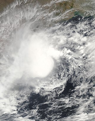
Cyclonic Storm Bijli, was the first tropical cyclone to form during the 2009 North Indian Ocean cyclone season. Bijli formed from an area of Low Pressure on April 14. Later that evening, RSMC New Delhi upgraded the low-pressure area to a Depression and designated it as BOB 01. The Joint Typhoon Warning Center (JTWC) then issued a Tropical Cyclone Formation Alert for the system and soon after designated it as Tropical Depression 01B. On the evening of April 15, both RSMC New Delhi and the JTWC reported that the system had intensified into a tropical storm, with the former naming it Bilji. Soon after, Bilji reached its peak intensity as it approached the coast of Bangladesh. However, on the morning of April 17, Bijli weakened to a deep depression due to land interaction, before making landfall just south of Chittagong. The remnants of Bilji continued to weaken as they tracked across northern Myanmar, before RSMC New Delhi issued their last advisory on April 18. The word Bijli refers to lightning in Hindi.

<span class="mw-page-title-main">Tropical cyclones in Myanmar</span>

At least 29 tropical cyclones have affected Myanmar, a country adjacent to the Bay of Bengal in mainland Southeast Asia. Myanmar has witnessed some of the deadliest storms in the Bay of Bengal, including Cyclone Nargis in May 2008, which struck the low-lying Irrawaddy Delta near Yangon. Its winds and storm surge killed an estimated 140,000 people and left nearly $10 billion in damage. The country's worst natural disaster in the 20th century was a cyclone in 1968, which killed more than 1,000 people when it hit Rakhine State in northwestern Myanmar. One of the most powerful storms to ever hit the country was Cyclone Mocha, which it moved ashore northwestern Myanmar in May 2023, killing at least 413 people.

<span class="mw-page-title-main">Cyclone Viyaru</span>

Cyclonic Storm Viyaru, operationally known as Cyclonic Storm Mahasen, was a relatively weak tropical cyclone that caused loss of life across six countries in Southern and Southeastern Asia. Originating from an area of low pressure over the southern Bay of Bengal in early May 2013, Viyaru slowly consolidated into a depression on May 10. The depression gained forward momentum and attained gale-force winds on May 11 and was designated as Cyclonic Storm Viyaru, the first named storm of the season. Owing to adverse atmospheric conditions, the depression struggled to maintain organized convection as it moved closer to eastern India. On May 14, the exposed circulation of Viyaru turned northeastward. The following day, conditions again allowed for the storm to intensify. Early on May 16, the cyclone attained its peak intensity with winds of 85 km/h (55 mph) and a barometric pressure of 990 mbar. Shortly thereafter Viyaru made landfall near Chittagong, Bangladesh. On May 17, it moved over the eastern Indian state of Nagaland.

<span class="mw-page-title-main">2003 Sri Lanka cyclone</span> Tropical cyclone

In May 2003, a tropical cyclone officially called Very Severe Cyclonic Storm BOB 01 produced the worst flooding in Sri Lanka in 56 years. The first storm of the 2003 North Indian Ocean cyclone season, it developed over the Bay of Bengal on May 10. Favorable environmental conditions allowed the system to intensify steadily while moving northwestward. The storm reached peak maximum sustained winds of 140 km/h (85 mph) on May 13, making it a very severe cyclonic storm according to the India Meteorological Department (IMD), which is the official Regional Specialized Meteorological Center for the basin. The cyclone drifted north over the central Bay of Bengal, gradually weakening due to heightened wind shear. Turning eastward, the storm deteriorated to a deep depression on May 16 before it curved northeastward and re-intensified into a cyclonic storm. It came ashore in western Myanmar and dissipated over land the following day.

<span class="mw-page-title-main">2004 Myanmar cyclone</span> North Indian tropical cyclone in 2004

The 2004 Myanmar cyclone was considered the worst to strike the country since 1968. The second tropical cyclone of the 2004 North Indian Ocean cyclone season, it formed as a depression on May 16 in the central Bay of Bengal. With low wind shear and a surge in the monsoon trough, the storm intensified while meandering over open waters. The storm eventually began a steady northeastward motion due to a ridge to the north over India. While approaching land, an eye developed in the center of the storm, indicative of a strong cyclone. On May 19, the cyclone made landfall along northwestern Myanmar near Sittwe, with maximum sustained winds estimated at 165 km/h (105 mph) by the India Meteorological Department. The storm rapidly weakened over land, although its remnants spread rainfall into northern Thailand and Yunnan province in China.

<span class="mw-page-title-main">2015 North Indian Ocean cyclone season</span> North Indian Ocean tropical cyclone season

The 2015 North Indian Ocean cyclone season was an event in the annual cycle of tropical cyclone formation. The North Indian Ocean cyclone season has no official bounds, but cyclones tend to form between months of April and December, with the peak from May to November. These dates conventionally delimit the period of each year when most tropical cyclones form in the northern Indian Ocean.

<span class="mw-page-title-main">2017 North Indian Ocean cyclone season</span> North Indian Ocean tropical cyclone season

The 2017 North Indian Ocean cyclone season was a below average yet deadly season in the annual cycle of tropical cyclone formation. This season produced only three named storms, of which one only intensified into a very severe cyclonic storm. The North Indian Ocean cyclone season has no official bounds but cyclones tend to form between April and December with the two peaks in May and November. These dates conventionally delimit the period of each year when most tropical cyclones form in the northern Indian Ocean. The season began with the formation Cyclone Maarutha on April 15 and ended with the dissipation of a deep depression on December 9.

<span class="mw-page-title-main">Cyclone Mora</span>

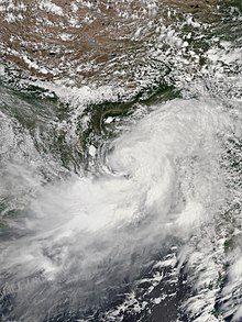
Severe Cyclonic Storm Mora was a moderate but deadly tropical cyclone that caused widespread devastation and severe flooding in Sri Lanka, Andaman and Nicobar Islands, Bangladesh, Myanmar and Northeast India in May 2017. The second named storm of the 2017 annual cyclone season, Mora developed from an area of low pressure over the southeastern Bay of Bengal on May 28. Mora reached peak strength with maximum sustained winds of 110 km/h (70 mph). The cyclone made landfall near Chittagong on the morning of May 30 and steadily weakened, dissipating early in the morning on May 31. Across its path, Mora dropped a large amount of rain, including 225mm of rainfall in Chittagong and northeast India. The storm is estimated to have caused damages nearing US$300 million.

<span class="mw-page-title-main">2018 North Indian Ocean cyclone season</span> North Indian Ocean tropical cyclone season

The 2018 North Indian Ocean cyclone season was one of the most active North Indian Ocean cyclone seasons since 1992, with the formation of fourteen depressions and seven cyclones. The North Indian Ocean cyclone season has no official bounds, but cyclones tend to form between April and December, with the two peaks in May and November. These dates conventionally delimit the period of each year when most tropical cyclones form in the northern Indian Ocean.

<span class="mw-page-title-main">Cyclone Mocha</span> North Indian Ocean cyclone in 2023

Extremely Severe Cyclonic Storm Mocha was a powerful and deadly tropical cyclone in the North Indian Ocean which affected Myanmar and parts of Bangladesh in May 2023. The second depression and the first cyclonic storm of the 2023 North Indian Ocean cyclone season, Mocha originated from a low-pressure area that was first noted by the India Meteorological Department (IMD) on 8 May. After consolidating into a depression, the storm tracked slowly north-northwestward over the Bay of Bengal, and reached extremely severe cyclonic storm intensity. After undergoing an eyewall replacement cycle, Mocha rapidly strengthened, peaking at Category 5-equivalent intensity on 14 May with winds of 280 km/h (175 mph), tying with Cyclone Fani as the strongest storm on record in the north Indian Ocean, in terms of 1-minute sustained winds. Mocha slightly weakened before making landfall, and its conditions quickly became unfavorable. Mocha rapidly weakened once inland and dissipated shortly thereafter.

References

  1. 1 2 3 4 5 6 7 8 9 10 11 12 13 14 15 16 Cyclonic Storm (CS) Komen over the Bay of Bengal (26 July-02 August 2015) (PDF) (Report). India Meteorological Department. August 2015. Archived from the original (PDF) on 23 April 2016. Retrieved February 23, 2016.
  2. "Significant Tropical Weather Advisory". Joint Typhoon Warning Center. July 27, 2015. Archived from the original on July 27, 2015. Retrieved February 23, 2016.
  3. "Tropical Cyclone Formation Alert". Joint Typhoon Warning Center. July 28, 2015. Archived from the original on July 30, 2015. Retrieved February 23, 2016.
  4. "Tropical Cyclone 02B (Two) Warning NR 001". Joint Typhoon Warning Center. July 29, 2015. Archived from the original on July 30, 2015. Retrieved February 23, 2016.
  5. "Tropical Cyclone 02B (Two) Warning NR 002". Joint Typhoon Warning Center. July 29, 2015. Archived from the original on July 30, 2015. Retrieved February 23, 2016.
  6. "Tropical Cyclone 02B (Two) Warning NR 004". Joint Typhoon Warning Center. July 29, 2015. Archived from the original on July 30, 2015. Retrieved February 24, 2016.
  7. "Tropical Cyclone 02B (Two) Warning NR 005". Joint Typhoon Warning Center. July 30, 2015. Archived from the original on July 30, 2015. Retrieved February 24, 2016.
  8. "Tropical Cyclone 02B (Two) Warning NR 006". Joint Typhoon Warning Center. July 30, 2015. Archived from the original on July 30, 2015. Retrieved February 24, 2016.
  9. "Myanmar admits 'weak' flood response as disaster spreads". ReliefWeb. Agence France-Presse. August 4, 2015. Archived from the original on April 5, 2016. Retrieved March 14, 2016.
  10. "Heavy rains trigger floods in Gujarat, Rajasthan, West Bengal, Odisha; 81 dead". Press Trust of India. August 2, 2015. Archived from the original on March 14, 2016. Retrieved March 25, 2016.
  11. Anindita Sanyal (July 31, 2015). "Cyclone Komen Makes Landfall in Bangladesh. Bengal, Odisha Brace For Impact". NDTV. Archived from the original on April 16, 2016. Retrieved March 23, 2016.
  12. DMIC Situation Report on Cyclonic Storm (Komen) situation, Friday, July 31, 2015. Government of Bangladesh (Report). ReliefWeb. July 31, 2015. Archived from the original on April 5, 2016. Retrieved February 29, 2016.
  13. 1 2 3 4 FAO/WFP Crop and Food Security Assessment Mission to Myanmar (PDF). Food and Agriculture Organization (Report). ReliefWeb. March 16, 2016. Archived (PDF) from the original on April 5, 2016. Retrieved March 22, 2016.
  14. 1 2 3 4 5 Nick Wiltgen (August 5, 2015). "Floods, Landslides in Myanmar, India and Other Asian Countries Leave At Least 493 Dead". Weather.com. Archived from the original on April 19, 2019. Retrieved April 5, 2016.
  15. 1 2 3 Love thy neighbor: Bangladesh donates US$800,000 for flood effort. Mizzima News (Report). ReliefWeb. August 7, 2015. Archived from the original on June 3, 2016. Retrieved March 15, 2016.
  16. "Thousands evacuated as cyclone set to hit Bangladesh". ReliefWeb. Agence France-Presse. July 30, 2015. Archived from the original on April 5, 2016. Retrieved February 29, 2016.
  17. Bangladesh and Myanmar/Burma - Floods (ECHO, Government of Bangladesh, Government of Myanmar) (ECHO Daily Flash of 7 August 2015) (Report). ReliefWeb. European Commission Humanitarian Aid Office. August 7, 2015. Archived from the original on April 5, 2016. Retrieved March 15, 2016.
  18. Centre for Research on the Epidemiology of Disasters. "EM-DAT: The Emergency Events Database" . Université catholique de Louvain.
  19. Asia and the Pacific: Weekly Regional Humanitarian Snapshot (18-24 August 2015). United Nations Office for the Coordination of Humanitarian Affairs (Report). ReliefWeb. August 29, 2015. Archived from the original on April 5, 2016. Retrieved March 21, 2016.
  20. Nur Uddin Alamgir (August 22, 2015). "Rainfall causes severe damage to embankments in Ctg". Daily Sun. Retrieved February 29, 2016.
  21. "At least 180 dead, a million displaced in India floods". ReliefWeb. Agence France-Presse. August 4, 2015. Archived from the original on April 5, 2016. Retrieved February 29, 2016.
  22. Tim Marcin (August 2, 2015). "Floods In India Leave At Least 81 Dead Following Cyclone Komen: Report". International Business Times. Archived from the original on April 4, 2016. Retrieved March 23, 2016.
  23. "Joint Needs Assessment Report: West Bengal Floods 2015" (PDF). Sphere India. August 30, 2015. Archived (PDF) from the original on May 8, 2019. Retrieved March 23, 2016.
  24. Cyclone Komen weakens, heavy rainfall continues across Myanmar. New Light of Myanmar (Report). ReliefWeb. July 31, 2015. Archived from the original on December 18, 2015. Retrieved February 29, 2016.
  25. Adam Voiland (November 8, 2015). "Satellite Spots Massive Tonzang Landslide". NASA Earth Observatory. Archived from the original on May 31, 2016. Retrieved March 22, 2016.
  26. Myanmar floods: Families lose everything. CARE (Report). ReliefWeb. August 17, 2015. Archived from the original on June 3, 2016. Retrieved March 15, 2016.
  27. Caritas provides aid to victims of worst floods in Myanmar. Caritas (Report). ReliefWeb. September 28, 2015. Archived from the original on January 7, 2016. Retrieved March 15, 2016.
  28. 1 2 3 Revised Flood Response Plan For Myanmar (August to December 2015) (Report). ReliefWeb. United Nations Office for the Coordination of Humanitarian Affairs. November 4, 2015. Archived from the original on June 3, 2016. Retrieved March 22, 2016.
  29. 1 2 3 "Hundreds dead, millions displaced as monsoon rains heap misery on Asia". ReliefWeb. Agence France-Presse. August 3, 2015. Archived from the original on April 23, 2016. Retrieved February 29, 2016.
  30. 1 2 UNHCR assists flood victims in Myanmar's Rakhine and Kachin states. United Nations High Commission for Refugees (Report). ReliefWeb. August 4, 2015. Archived from the original on April 25, 2016. Retrieved March 14, 2016.
  31. Humanitarian Implementation Plan (HIP) South East Asia and the Pacific (ECHO/-XA/BUD/2015/91000) Last update: 06/08/2015 Version: 2. European Commission Humanitarian Aid Office (Report). ReliefWeb. August 7, 2015. Archived from the original on June 3, 2016. Retrieved March 15, 2016.
  32. Emergency appeal operations update Myanmar: Floods (PDF) (Report). ReliefWeb. International Red Cross and Red Crescent Movement. August 29, 2015. Archived (PDF) from the original on June 3, 2016. Retrieved March 21, 2016.
  33. Myanmar floods deal major blow to country's agriculture. Food and Agriculture Organization (Report). ReliefWeb. September 3, 2015. Archived from the original on June 3, 2016. Retrieved March 21, 2016.
  34. Asia Pacific Food Price and Policy Monitor, August 2015 - Issue 24. Food and Agriculture Organization (Report). ReliefWeb. August 31, 2015. Archived from the original on June 3, 2016. Retrieved March 21, 2016.
  35. 1 2 3 OCHA Flash Update No 1: Myanmar Floods Emergency, 01 August 2015. United Nations Office for the Coordination of Humanitarian Affairs (Report). ReliefWeb. August 1, 2015. Archived from the original on March 15, 2016. Retrieved February 29, 2016.
  36. UNHCR assists flood victims in Myanmar's Rakhine and Kachin states. United Nations High Commissioner for Refugees (Report). ReliefWeb. August 4, 2015. Archived from the original on April 25, 2016. Retrieved February 29, 2016.
  37. 1 2 Myanmar floods: ICRC joins relief efforts in Rakhine. International Committee of the Red Cross (Report). ReliefWeb. August 5, 2015. Archived from the original on April 25, 2016. Retrieved March 14, 2016.
  38. 1 2 3 Flood-hit Burma appeals for international aid. Democratic Voice of Burma (Report). ReliefWeb. August 4, 2015. Archived from the original on June 3, 2016. Retrieved February 29, 2016.
  39. Kelly MacNamara (August 6, 2015). "Myanmar villagers fight floods with just sand bags and hope". ReliefWeb. Agence France-Presse. Archived from the original on June 3, 2016. Retrieved March 14, 2016.
  40. IHH sends emergency aid to flood stricken Arakan (Report). ReliefWeb. Internationale Humanitäre Hilfsorganisation e.V. August 10, 2015. Archived from the original on June 3, 2016. Retrieved March 21, 2016.
  41. 1 2 Red Cross responds to Myanmar flood emergency (Report). ReliefWeb. Australian Red Cross. August 4, 2015. Archived from the original on June 3, 2016. Retrieved March 14, 2016.
  42. Flooding Crisis in Burma (Myanmar): An urgent appeal from Dr Sasa. HART (Report). ReliefWeb. August 6, 2015. Archived from the original on June 3, 2016. Retrieved March 15, 2016.
  43. Myanmar/Burma - Floods - ECHO Daily Map 11/9/2015 (Report). ReliefWeb. European Commission Humanitarian Aid Office. September 11, 2015. Archived from the original on June 3, 2016. Retrieved March 21, 2016.
  44. Update on Myanmar Flood Response - 15 November 2015 (Report). ReliefWeb. International Committee of the Red Cross. November 15, 2015. Archived from the original on March 24, 2016. Retrieved March 22, 2016.
  45. At Least 55 Dead From Floods in Western Myanmar (Report). ReliefWeb. Radio Free Asia. August 6, 2015. Archived from the original on June 3, 2016. Retrieved March 15, 2016.
  46. Disasters in Asia and the Pacific: 2015 Year in Review (PDF) (Report). ReliefWeb. United Nations Economic and Social Commission for Asia and the Pacific. March 10, 2016. Archived (PDF) from the original on April 8, 2016. Retrieved March 22, 2016.
  47. Myanmar: Post-disaster needs assessment of floods and landslides July - September 2015 (PDF) (Report). World Bank. Government of the Union of Myanmar. November 2015. Retrieved March 15, 2016.
  48. Flood-hit Burma appeals for international aid. Democratic Voice of Burma (Report). ReliefWeb. August 4, 2015. Archived from the original on June 3, 2016. Retrieved March 14, 2016.
  49. Additional humanitarian assistance to Myanmar. Government of Australia (Report). ReliefWeb. August 7, 2015. Archived from the original on June 3, 2016. Retrieved March 15, 2016.
  50. USAID announces humanitarian assistance for flood-affected people in Burma. United States Agency for International Development (Report). ReliefWeb. August 6, 2015. Archived from the original on June 3, 2016. Retrieved March 15, 2016.
  51. "Farm debt rises as Myanmar floodwaters recede". ReliefWeb. IRIN. August 19, 2015. Archived from the original on April 25, 2016. Retrieved March 21, 2016.
  52. President pledges livelihood assistance for Rakhine flood victims. New Light of Myanmar (Report). ReliefWeb. August 6, 2015. Archived from the original on April 25, 2016. Retrieved March 15, 2016.
  53. Aung Ko Win's KBZ Charity Tops $3.6m in Flood Aid. Irrawaddy (Report). ReliefWeb. August 9, 2015. Archived from the original on April 25, 2016. Retrieved March 15, 2016.
  54. Myanmar: Recovery work begins to support flood-affected communities. International Committee of the Red Cross (Report). ReliefWeb. September 7, 2015. Archived from the original on October 8, 2020. Retrieved March 14, 2016.
  55. What's Happening in Myanmar One Month Onward. World Food Programme (Report). ReliefWeb. September 15, 2015. Archived from the original on April 25, 2016. Retrieved March 21, 2016.
  56. Prices of commodities shoot up in Maungdaw. Kaladan Press Network (Report). ReliefWeb. August 12, 2015. Archived from the original on April 25, 2016. Retrieved March 15, 2016.
  57. LIFT, and the Bill and Melinda Gates Foundation alleviate livelihood loss in Rakhine State. International Rescue Committee (Report). ReliefWeb. October 13, 2015. Archived from the original on April 25, 2016. Retrieved March 21, 2016.
  58. Post-disaster assessment in Myanmar highlights disproportionate impact on women. UN Women (Report). ReliefWeb. December 17, 2015. Archived from the original on April 25, 2016. Retrieved March 22, 2016.
Cyclonic Storm Komen
Komen 2015-07-30 0658Z.jpg
Komen approaching the Bangladeshi coast on July 30