Location and access
The street passes through five Montreal boroughs: Ahuntsic-Cartierville, Le Plateau-Mont-Royal, Rosemont–La Petite-Patrie, Ville-Marie, and Villeray–Saint-Michel–Parc-Extension.
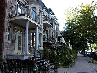
Its main section starts at Notre-Dame Street and continues up to Jarry Street. Two other sections exist north of the main section: the first is from Du Pélican Street to Charland Street, and the second is from De Port-Royal Street to north of Gouin Boulevard. D'Iberville station, part of the Montreal Metro's Blue Line, is located at its intersection with Jean-Talon Street. [2] The 94 D'Iberville bus of the STM circulates along the street for much of its path, connecting D'Iberville station to Frontenac station. [3]
From Le Plateau-Mont-Royal to Ville-Marie, D'Iberville Street runs parallel to Frontenac Street, where both streets' southern end is at Notre-Dame Street. Frontenac Street's northern end is at D'Iberville Street, after Mont-Royal Avenue, where the two streets then merge and continue as D'Iberville Street.

Outremont is a federal electoral district in Montreal, Quebec, Canada, that has been represented in the House of Commons of Canada since 1935. It was known as Outremont—Saint-Jean from 1947 to 1966. Its population in 2006 was 95,711. Its current Member of Parliament is Rachel Bendayan of the Liberal Party of Canada.
Rosemont–La Petite-Patrie is a borough (arrondissement) in the city of Montreal, Quebec, Canada. It is located centre-east of the island.

Le Plateau-Mont-Royal is a borough (arrondissement) of the city of Montreal, Quebec, Canada.

Saint Denis Street is a major north–south thoroughfare in Montreal, Quebec.
The Montreal Public Libraries Network is the public library system on the Island of Montreal in Quebec, Canada. It is the largest French language public library system in North America, and also has items in English and other languages. Its central branch closed in March 2005 and its collections incorporated into the collections of the Grande Bibliothèque.

Mount Royal Avenue, once named Tannery Road, is a street in Montreal, Quebec, Canada. The main part of the street transects the borough of Le Plateau-Mont-Royal, from Park Avenue at the foot of Mount Royal, for which the road is named, to Frontenac St. Another section in Rosemont–La Petite-Patrie runs from Molson St. to Pie-IX Boulevard. West of Park Avenue, the road continues into Outremont, skirting the northern rim of the mountain to a terminus at Vincent d'Indy Avenue near the Édouard-Montpetit metro station.

Hochelaga-Maisonneuve is a provincial electoral district in Quebec, Canada, that elects members to the National Assembly of Quebec. The district is located within Montreal, and its territory mostly covers the borough of Mercier–Hochelaga-Maisonneuve, and also parts of Rosemont–La Petite-Patrie, Ville-Marie and Le Plateau-Mont-Royal boroughs. It is bordered to the east by the Canadian National Railway yard, to the south by the Saint Lawrence River, to the north by Rachel and Sherbrooke Streets and to the west by Frontenac Street.

Saint Urbain Street is a major one-way street located in Montreal, Quebec, Canada. The original, southernmost section of the street was built by Urbain Tessier, a farmer and carpenter who settled in the area. The name also makes reference to Saint Urbain.
Saint Joseph Boulevard is a major boulevard located east of Mount Royal in Montreal, Quebec, Canada. Although it is mainly residential, it is a major east–west artery in the Plateau Mont-Royal and the Rosemont–La Petite-Patrie boroughs. Its intersection with D'Iberville Street is known as the infamous Tunnel de la mort. Laurier metro station is located on the boulevard. It also intersects Route 335.
Pine Avenue is an east–west street in Montreal, Quebec, Canada. This street serves as the dividing line between the downtown Ville-Marie borough and borough of Le Plateau-Mont-Royal, and also serves as the northern border of the Golden Square Mile historic district, further west.
Papineau Avenue is the longest north–south street in Montreal, Quebec, Canada. The part of the street between Henri Bourassa Boulevard and Quebec Autoroute 40 is the Montreal portion of Quebec Autoroute 19, commonly referred to as Autoroute Papineau. North of Henri Bourassa Boulevard, it becomes a true autoroute before crossing the Rivière des Prairies on the Papineau-Leblanc Bridge. In the south, the avenue ends at Notre-Dame Street.

"Tunnel de la mort"(Tunnel of Death) is the informal name given, in Montreal, to the notoriously dangerous intersection of Rue d'Iberville and Boulevard Saint-Joseph, at the border of the Rosemont–La Petite-Patrie and Plateau-Mont-Royal boroughs. The intersection owes this name to the dangerously poor visibility caused by the three railway overpasses immediately to the north, east, and west of it, and by concrete retaining walls on all four corners. More than 250 serious accidents were reported at that intersection between 1992 and 2002.
Berri Street is a major north–south street located in Montreal, Quebec, Canada. Berri Street links De la Commune Street in the south and Somerville Street in the north. The street is interrupted between Rosemont Boulevard and Jean Talon Street.

Laurier Avenue is a commercial and residential street in Montreal, Quebec, Canada. It crosses the boroughs of Outremont, Le Plateau-Mont-Royal and Rosemont–La Petite-Patrie. It is known for its cafés, restaurants and specialty stores, especially near Park Avenue and east of Sir Wilfrid Laurier Park.

St. Hubert Street is a north–south street that spans the island of Montreal. It is located east of Berri Street.

Assomption Boulevard is a main north–south street in the Montreal boroughs of Mercier–Hochelaga-Maisonneuve, Rosemont–La Petite-Patrie and Saint-Léonard.
Lacordaire Boulevard is a north-south thoroughfare in Montreal.

De Lorimier Avenue is a major north–south avenue located in Montreal, Quebec, Canada.
The boroughs of Montreal, like the rest of Canada and the world, have been individually impacted by the COVID-19 pandemic.
