Waigeo is an island in Southwest Papua province of eastern Indonesia. The island is also known as Amberi, or Waigiu. It is the largest of the four main islands in the Raja Ampat Islands archipelago, between Halmahera and about 65 kilometres to the north-west coast of New Guinea. The Dampier Strait separates it from Batanta, and the Bougainville Strait from the Kawe Islands to its north-west. The "inner sea" that nearly cleaves the island in two is Mayalibit Bay, also known as the Majoli Gulf.

The Bird's Head Peninsula or Doberai Peninsula, is a large peninsula that makes up the northwest portion of the island of New Guinea, comprising the Indonesian provinces of Southwest Papua and West Papua. It is often referred to as The Vogelkop, and is so named because its shape looks like a bird's head on the island of New Guinea. The peninsula at the opposite end of the island is called the Bird's Tail Peninsula. The peninsula just to the south is called the Bomberai Peninsula.

Raja Ampat, or the Four Kings, is an archipelago located off the northwest tip of Bird's Head Peninsula on the island of New Guinea, in Indonesia's Southwest Papua province. It comprises over 1,500 small islands, cays, and shoals surrounding the four main islands of Misool, Salawati, Batanta, and Waigeo, and the smaller island of Kofiau.

Misool, formerly spelled Mysol or Misol, is one of the four major islands in the Raja Ampat Islands in Southwest Papua, Indonesia. Its area is 2,034 km2. The highest point is 561 m and the main towns are Waigama, located on the island's northwest coast, and Lilinta on the island's southeast coast.
Salawati is one of the four major islands in the Raja Ampat Islands in Southwest Papua, Indonesia. Its area is 1,623 km2. Salawati is separated from New Guinea to the southeast by the Sele Strait, and from Batanta to the north by the Pitt Strait.
Batanta is one of the four major islands in the Raja Ampat Islands in Southwest Papua province, Indonesia. Its area is 453 km² and its highest point is 1184 m. The Pitt Strait separates it from Salawati, while the Dampier Strait separates it from Waigeo.

The Asia Islands are a group of three small islands in the open sea north of the Raja Ampat Archipelago of eastern Indonesia. They are located 117 kilometres (73 mi) north of the island of Waigeo, around 50 kilometres (31 mi) north of the last of the Ayu Islands, and 210 kilometres (130 mi) south of the island of Tobi in Palau. The individual islands are known as Fani, Igi and Miarin. On the largest island of Fani, there is a pier and a small settlement, intermittently inhabited by visitors from Reni and Rutum. Administratively the Asia Islands are part of the Raja Ampat Regency of the province of Southwest Papua.

Fam Islands are a group of islands in the Raja Ampat Archipelago, which are administered as part of the Indonesian province of Southwest Papua. The main islands are Fam, Penemu, Inus and Yar. They lie northwest of Batanta island, in the straits between Waigeo and Batanta and New Guinea.
The Halmahera Sea languages, also known as the Raja Ampat-South Halmahera languages, are a branch of Malayo-Polynesian languages of eastern Indonesia. They are spoken on islands in the Halmahera Sea, and on its margins from the south-eastern coast of Halmahera to the Raja Ampat Islands off the western tip of New Guinea.
Ma'ya is an Austronesian language of the Raja Ampat islands in Southwest Papua, Indonesia. It is spoken by about 6,000 people in coastal villages on the islands Misool, Salawati, and Waigeo. It is spoken on the boundary between Austronesian and Papuan languages.

Raja Ampat Regency is a regency of Southwest Papua Province of Indonesia. The regency, which was formed based on the Law 26 of 2002, was inaugurated on 12 April 2003, and consists of a number of groups of islands situated off the north-west end of West Papua; the four main islands from south to north are Misool, Salawati, Batanta, and Waigeo. At present, the regency covers a land area of 7,559.60 km2, with a total area stated as 67,379.61 km2. It had a population of 42,508 at the 2010 Census, and 64,141 at the 2020 Census; the official estimate as at mid 2021 was 65,403. The principal town lies at Waisai on Waigeo Island.
Duriankari, or Duriankere, is a possibly extinct Papuan language of Indonesian Papua. It is associated with the village of Duriankari at the southern tip of the island of Salawati, which is part of the Raja Ampat Archipelago and is adjacent to the Bird's Head Peninsula of the West Papuan mainland.
Ambel (Amber), also known as Waigeo after the island where it is primarily spoken, is a heavily Papuan-influenced Austronesian language spoken on the island of Waigeo in the Raja Ampat archipelago near the northwestern tip of West Papua, Indonesia. It is spoken by approximately 1,600 people. It is endangered, as the population is shifting to Papuan Malay and few people born after the year 2000 have any knowledge of the language.
Pitt Strait (Indonesia), falls within the waters of the Indonesian province of Southwest Papua. The strait separates the Raja Ampat islands of Batanta and Salawati and links the Ceram Sea to the Pacific Ocean. To its west lies Dampier Strait, which separates Batanta island from Waigeo island. The Sagewin Strait name refers to Sagewin Island, which lies at the south east side of Pitt Strait, close to Salawati.
Sagewin, or Sagawin, is a small uninhabited island in the Raja Ampat Archipelago of eastern Indonesia. It lies off the north-western tip of the larger island of Salawati and is surrounded by the waters of the Pitt Strait, which separates Salawati from the island of Batanta. The island of Sagewin is 7.3 kilometres in length, and has a mean elevation of 20 meters.

Warir, or Waiji, is an island in the Raja Ampat Archipelago of Southwest Papua, Indonesia. Situated in the Sele Strait, it lies off the eastern coast of the larger island of Salawati. It has an area of 42.8 square kilometres (16.5 sq mi), its length north to south is about 9 kilometres (5.6 mi), and its east-west extent varies between 2.5 kilometres (1.6 mi) and 6 kilometres (3.7 mi). It is relatively low-lying, with no point exceeding an elevation of 80 metres (260 ft). Its interior is forested, with mangroves fringing the coastal areas, and some agricultural land in the north. The small settlement of Wamega is situated on the north-west coast.

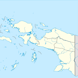
Southwest Papua is a province of Indonesia, and is a fraction of Western New Guinea. Despite being named southwest, it is a misnomer and this province is actually located in the northwest edge of Papua. The area that belongs to this province includes the Greater Sorong area which consists of Sorong City, Sorong Regency, South Sorong Regency, Maybrat Regency, Tambrauw Regency, and Raja Ampat Regency. The Draft Law (RUU) on the Establishment of the Southwest Papua Province has been passed into law and becomes the 38th province in Indonesia.
The Salawati Kingdom is the Islamic kingdom that once stood in Salawati Island, Raja Ampat Regency, Southwest Papua. The center of the Salawati kingdom was located in the Samate village which is currently located in the North Salawati district.