Darwazi Bala District

Last updated
Darwazi Bala
(ولسوالی دروازبالا (نسی
Afghanistan Badakhshan Darwazi Bala district location.svg
Coordinates: Coordinates: 38°08′40″N71°14′01″E / 38.14444°N 71.23361°E / 38.14444; 71.23361
District Badakhshan
Government
  Type District council
Population
  Estimate ([ citation needed ]) 11,000
Tajik-Afghan Friendship Bridge in Darwazi Bala Bridge Qalaikhum & Nusay of Darwaz.jpg
Tajik–Afghan Friendship Bridge in Darwazi Bala

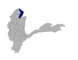
Darwazi Bala, also known as Nusay, [1] is a district in Badakhshan Province, Afghanistan. It was created in 2005 from part of Darwaz District. It is home to approximately 11,000 residents.

Badakhshan Province Province in Afghanistan

Badakhshan Province is one of the 34 provinces of Afghanistan, located in the farthest northeastern part of the country between Tajikistan and northern Pakistan. It shares a 56.5-mile (91 km) border with China.

Darwaz District Place in Badakhshan, Afghanistan

Darwaz district was a district in Badakhshan Province in Afghanistan until 2005. It was part of the historic region Darwaz which is now divided between Afghanistan and Tajikistan. In 2005 Darwaz District was subdivided into Maimay District, Darwazi Bala District, and Shekay District. Some maps use the name Darwaz for Maimay District. The district was historically part of the Darvaz principality, a semi-independent statelet ruled by a mir.

This district borders the Shekay, Kuf Ab, and Maimay districts, along with districts in Darvoz, Gorno-Badakhshan Autonomous Province, Tajikistan.

Shekay District Place in Badakhshan, Afghanistan

Shekay or Shikai Persian: شهرستان شِکی‎ is one of the 28 districts of Badakhshan Province in northeastern Afghanistan. It was created in 2005 from part of Darwaz District and is home to approximately 26,000 residents. This district borders Nusay and Kuf Ab districts in Badakhshan and also Darvoz District in the Gorno-Badakhshan Autonomous Region of Tajikistan.

Kuf Ab District Place in Badakhshan, Afghanistan

Kuf Ab is one of the 28 districts of Badakhshan Province in eastern Afghanistan. It was created in 2005 from part of Khwahan and is home to approximately 21,400 residents. This district borders with the Districts Khwahan, Shekay, Nusay, Maimay, Raghistan, And with is district Darvoz Gorno-Badakhshan Autonomous Province,  Tajikistan.

Maimay District Place in Badakhshan, Afghanistan

Maimay, also known as Darwaz-e Payin, or simply Darwaz, is a district in Badakhshan Province, Afghanistan. It was created in 2005 from part of Darwaz District. It is home to approximately 12,000 residents. This district borders the Kuf Ab, Raghistan, Shighnnan, and Nusay districts, along with some districts in the Gorno-Badakhshan Autonomous Province, Tajikistan, including Vanj, Rushon, and Shughnon. The district was historically part of the Darwaz principality, a semi-independent statelet ruled by a mir.

The district was historically part of the Darvaz principality, a semi-independent statelet ruled by a mir . [2]

Darvaz (region)

Darvaz, alternatively spelt Darwaz, Darvoz, or Darwoz, was an independent principality until the 19th century, ruled by a mir and its capital was at Kalai-Khumb. The kingdom controlled territory on the left and right banks of the Oxus River. In 1878 Darvaz was invaded by neighboring Bukhara and absorbed into the Bukharan Emirate. In 1895 the left bank of Darvaz was transferred to Afghanistan as part of a border agreement. In the 1920s the portion of Darvaz located in the Tajik Soviet Socialist Republic in the Soviet Union was assigned to the Gharm Oblast. When the Gharm Oblast was dissolved in 1955, Darvaz became part of the Gorno-Badakhshan Autonomous Oblast.

Mir is a rare ruler's title in princely states and an aristocratic title generally used to refer to a person who is a descendant of a commander in medieval Muslim tradition.

Related Research Articles

Gorno-Badakhshan Autonomous Region Region in Khorugh, Tajikistan

The Kuhistani Badakhshan Autonomous Region (Tajik: Вилояти Мухтори Кӯҳистони Бадахшон, Viloyati Muxtori Köhistoni Badaxshon; also known as Gorno-Badakhshan is an autonomous region in eastern Tajikistan. Located in the Pamir Mountains, it makes up 45% of the land area of the country but only 3% of its population.

Arghanj Khwa District District in Badakhshan, Afghanistan

Arghanj Khwa District is a district in Badakhshan Province, Afghanistan. It was created in 2005 from part of Yaftali Payan District, itself formed from the Fayzabad District. The district has a population of approximately 12,000 people.

Argo District District in Badakhshan Province, Afghanistan

Argo District is one of the 28 districts in Badakhshan Province, Afghanistan. It was created in 2005 from part of Fayzabad District and is home to approximately 45,000 residents.

Darvoz District District in Gorno-Badakhshan Autonomous Region, Tajikistan

Darvoz District or Nohiya-i Darvoz is a district in Tajikistan, located at the extreme north-west of the Gorno-Badakhshan Autonomous Region. It borders on Afghanistan to the south, along the Panj, and within Tajikistan on Khatlon Province to the west and on the Region of Republican Subordination to the north. Its administrative capital is Qal'ai Khumb. The population in Darvoz district is 23,600. The district was historically part of the Darvaz principality, a semi-independent statelet ruled by a mir.

Khwahan, Afghanistan Place in Badakhshan Province, Afghanistan

Khwahan /(Tajik: Хоҳон) is the name of a district, a fort and a town in Badakhshan Province in north-eastern Afghanistan. They are all located on the left bank of the Panj River, sub-regions of Darwaz.

Khwahan District Place in Badakhshan Province, Afghanistan

Khwahan District, is one of the 28 districts of Badakhshan Province, located in northeastern Afghanistan. The district capital is Khwahan. The population of the district is approximately 27,000. The district borders Raghistan to the southwest, Kuf Ab in the northeast, the Panj River in the northwest, and Shuro-obod district, Khatlon Province, of Tajikistan. Kuh-e kallat

Amurn Place in Badakhshan Province, Afghanistan

Amurn is a village in Darwaz District, Badakhshan Province in north-eastern Afghanistan.

Amrud Place in Badakhshan Province, Afghanistan

Amrud is a village located in the Darwaz area of Afghanistan, situated near the Amu Darya.

Tajik–Afghan bridge at Tem-Demogan

The Tajik–Afghan bridge at Tem-Demogan was opened on 3 November 2002. It spans the Panj River. It was the first of four bridges planned to be built with the assistance of the Aga Khan Foundation.

On March 4, 2012, at least three avalanches struck the Badakhshan province of northeastern Afghanistan. One of those avalanches destroyed a small village of about 200 people. The name of the village is uncertain; some sources call it Dasty and locate it in Darzab District, and others call it Sherin Nazim and locate it in Shekay District. Two other villages were affected by the avalanche. At least 50 people were killed in the disaster.

Darwaz Airport airport in Afghanistan

Darwaz Airport is a private use airport located near Darwaz, Badakhshan, Afghanistan.

Shekiay District, Afghanistan Place in Badakhshan, Afghanistan

Shekay or Shikai Persian: شهرستان شِکی‎ is one of the 28 Districts of Badakhshan Province in North eastern Afghanistan. It was created in 2005 from part of Darwaz District Badakhshan and is home to approximately 26,000 residents. This is district borders with the Afghan Nusay and Kuf Ab as well as Darvoz District district and Gorno-Badakhshan Autonomous Province in  Tajikistan.

Kuh-e Safed Khers

Kuh-e Safed Khers is a mountain in the Darwaz district of Badakhshan province, Afghanistan. This peak is 5,326 metres (17,474 ft) high.

References

  1. "Settled Population of Badakhshan province by Civil Division, Urban, Rural and Sex-2012-13" (PDF). Central Statistics Organization . Retrieved 1 October 2017.
  2. Seymour Becker. Russia’s Protectorates in Central Asia: Bukhara and Khiva, 1865-1924. Cambridge: Harvard University Press. 1968.

The United Nations Office for the Coordination of Humanitarian Affairs (OCHA) is a United Nations (UN) body formed in December 1991 by General Assembly Resolution 46/182. The resolution was designed to strengthen the UN's response to complex emergencies and natural disasters. Earlier UN organizations with similar tasks were the Department of Humanitarian Affairs (DHA), and its predecessor, the Office of the United Nations Disaster Relief Coordinator (UNDRO). In 1998, due to reorganization, DHA merged into OCHA and was designed to be the UN focal point on major disasters. It is a sitting observer of the political debate United Nations Development Group.