Derbyshire Dome

Last updated

A cross section of the Peak District showing the structure of an eroded dome Peak District Cross Section.gif
A cross section of the Peak District showing the structure of an eroded dome

The Derbyshire Dome is a geological formation across mid-Derbyshire in England.

Contents

Geology Map of the Peak District Geology Map of the Peak District.png
Geology Map of the Peak District

The White Peak area of the Peak District is named after the limestone plateau landscape of the 'Derbyshire Dome' anticline. The plateau is generally between 200m and 300m above sea level. This limestone outcrop is surrounded on the west, north and east by a horseshoe-shaped formation of younger sandstones (gritstones) and shales, known as the Dark Peak. The town of Buxton is at the western edge of the limestone region. The Triassic sandstones of the Midlands plain bound the south edge of the limestone region. The other main karst landscapes of England are the Yorkshire Dales and the Mendip Hills. [1] [2]

Formation

The layers of carboniferous limestone were formed from the carbonate shells of countless invertebrate sea creatures, deposited in a warm shallow sea in the Brigantian stage of the Carboniferous period (around 330 million years ago). About 30 million years later, coarser debris from rock erosion was washed onto the earlier shell layers. These deposits were compressed over time into rocks which were subsequently uplifted and folded into a dome. Later erosion of the younger Namurian-age sandstones (the finer shales and the rougher gritstones) has exposed the limestone strata. The shells can be seen as fossils (crinoids, trilobites and shellfish) in the limestone outcrops, cliffs and caves. At times when parts of the sea bed rose, plants grew and their decayed remains formed a few shallow deposits of coal on the western side of the dome. Volcanoes around the sea bed spewed out lava flows which have formed local outcrops of volcanic basalt (dolerite). [2] [3]

The Peak District is rich in minerals, formed from geothermal fluids being forced up through the fissures in the limestone. When these cooled and crystallised they formed widespread hydrothermal mineral veins of galena ore (lead sulphide), fluorospar, barytes, calcite and copper. Large veins are known as 'rakes'. [4]

Dolomite is a more resistant form limestone, created where magnesium has been introduced into the rock by ground water. Outcrops such as Rainster Rocks are found between Carsington and Hartington. [3]

The many steep-sided limestone dales (such as Chee Dale, Deep Dale, Lathkill Dale, Monk's Dale and Monsal Dale) have been formed by glacial erosion of the Visean-age limestone plateau.

Features

Stanage Edge gritstone escarpment Long Causeway, Stanage Edge.JPG
Stanage Edge gritstone escarpment

There are gritstone escarpments where the limestone plateau meets the Dark Peak horseshoe. These include: [5] [6]

White Peak limestone scenery - Parkhouse Hill & Chrome Hill from High Wheeldon Parkhouse Hill & Chrome Hill from High Wheeldon.jpg
White Peak limestone scenery - Parkhouse Hill & Chrome Hill from High Wheeldon

The sequence of alternating limestones and basalts in the Derbyshire Dome anticline was established between John Whitehurst in 1778 and White Watson in 1811, and John Farey provided names for them in 1811. [7] [8] From west to east the limestone strata include: [2]

Over millions of years, acidic groundwater has travelled through the limestone bedding planes and joints forming underground chambers and channels. This has created typical fluviokarst features of dry valleys, steep-sided gorges, and cave systems with stalactites and stalagmites. Numerous rivers disappear into underground channels in places called 'swallets' and reappear as springs in places called 'resurgences'. Many limestone dales have 'winterbourne' streams which flow in winter and after heavy rains but dry up over summer months. The gorge of Winnats Pass has cliffs up to 100m high. Dovedale, Deep Dale and Miller's Dale are other steep-sided gorges formed by Ice Age melt water. [1]

Notable caves are: Poole's Cavern at Buxton; Speedwell Cavern, Treak Cliffe Cavern, Blue John Cavern, Peak Cavern (the Devil's Arse) and Titan Cave (the deepest in Britain) at Castleton; Great Masson Cavern at Matlock, Thor's Cave in the Manifold Valley, Dove Holes in Dovedale and over 3 km of cave passages at Middleton Dale. Many Stone Age, Bronze Age and Roman artefacts (including animal and human remains) have been found in several of these caves, such as Dowel Cave, Fox Hole Cave and Thirst House. [9] Their archaeological importance is recognised in them being designated as Scheduled Monuments. [10] Ice Age animal bones were found by quarrymen in 1901 in an underground chamber at Victory Quarry at Dove Holes. These included sabre tooth tiger, mastodon, hyena and rhinoceros. Finds in fissures at other Buxton quarries have included bison and lion bones. [1] [2]

The limestone crags, cliffs and quarries and the gritstone edges of the Peak District offer some of the most challenging rock climbing in Europe, with over 10,000 graded routes. Popular locations with extensive routes include Stanage Edge, Froggatt Edge, The Roaches, Chee Dale and Middleton Dale. [11]

Industry

Limestone has been quarried in the Peak District since Roman times. It was used as building stone, for road aggregate and for making lime (also known as quicklime). Lime is produced easily by heating limestone and it has been used in mortar since ancient times, for fixing together the stone blocks of buildings. Lime has also been used as a soil improver in agriculture since the Middle Ages. There are hundreds of lime kilns from the 17th to 19th centuries and associated spoil heaps at many sites across the White Peak. Limestone is used in lead smelting as a flux to remove impurities. Millions of tons of limestone are removed from Derbyshire quarries every year. Buxton is the largest centre in Britain for limestone quarrying. Other large quarries are at Longcliffe near Matlock. [12] [13]

The larger outcrops of dolerite in the White Peak are quarried at Waterswallows Quarry near Buxton and at Ible Quarry near Bonsall. Dolerite is used as an ornamental stone (for buildings, memorials, paving, etc.) and is crushed for use in construction aggregate (for roads, railways, buildings, and dams). [14]

Lead ore (galena) has been mined across the White Peak since at least Roman times and until the last mine closed in the 1950s. The Romans used lead for water pipes, cisterns and weights. Lutudarum near Matlock was the administrative centre for Roman lead mining. Numerous lead pigs (ingots weighing about 50kg) bearing the mark for Lutudarum have been discovered in Derbyshire, near Hull and in Sussex. Principal lead mining sites include Lathkill Dale, Odin Mine at Castleton, Magpie Mine (a well-preserved mining complex), Bonsall and Via Gellia, Winster and Wirksworth. Limestone aquifers meant that mines were prone to flooding and so expensive drains (soughs) and pump engines were needed when extracting lead ore from deeper mines. The rock bearing the galena ore was crushed and smelted in cupola furnaces to extract the lead. Mined rock veins contained 10% or less galena, so mining sites are characterised by many spoil heaps of waste. [15]

Copper has been mined in the Peak District since the Bronze Age. Ecton Mines (Deep Ecton and Clayton) on the western edge of the Peak were a major complex for mining copper ore until their closure in 1891. [16] The site is a protected Scheduled Monument. [17]

Fluorspar was originally mined in the Peak District as a flux for iron smelting. Modern uses are for glass manufacture and production of hydrogen fluoride (with wide-ranging applications from pharmaceuticals to refrigerants). Sallet Hole Mine is a 19th-century fluorspar mine in the centre of Coombs Dale, which closed in 1998. Nearby Cavendish Mill has been a processing centre for fluorspar since 1965. [18] Also there was a major fluorspar mining centre at Masson Hill above Matlock. [4] Blue John is a purple and yellow banded fluorspar that is unique to the Peak District, only found in Blue John Cavern and in Treak Cliff Cavern at Castleton. It was prized in Victorian times for ornaments and jewellery. [19]

See also

Related Research Articles

<span class="mw-page-title-main">Peak District</span> Upland area in England

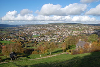
The Peak District is an upland area in England at the southern end of the Pennines. Mostly in Derbyshire, it extends into Cheshire, Greater Manchester, Staffordshire, West Yorkshire and South Yorkshire. It includes the Dark Peak, where moorland is found and the geology is dominated by gritstone, and the White Peak, a limestone area with valleys and gorges. The Dark Peak forms an arc on the north, east and west sides; the White Peak covers central and southern tracts. The historic Peak District extends beyond the National Park, which excludes major towns, quarries and industrial areas. It became the first of the national parks of England and Wales in 1951. Nearby Manchester, Stoke-on-Trent, Derby and Sheffield send millions of visitors – some 20 million live within an hour's ride. Inhabited from the Mesolithic era, it shows evidence of the Neolithic, Bronze and Iron Ages. Settled by the Romans and Anglo-Saxons, it remained largely agricultural; mining arose in the Middle Ages. Richard Arkwright built cotton mills in the Industrial Revolution. As mining declined, quarrying grew. Tourism came with the railways, spurred by the landscape, spa towns and Castleton's show caves.

<span class="mw-page-title-main">Derbyshire</span> Ceremonial county in the East Midlands of England

Derbyshire is a ceremonial county in the East Midlands of England. It borders Greater Manchester, West Yorkshire, and South Yorkshire to the north, Nottinghamshire to the east, Leicestershire to the south-east, Staffordshire to the south and west, and Cheshire to the west. The city of Derby is the county town.

<span class="mw-page-title-main">River Manifold</span> River in Staffordshire, England

The River Manifold is a river in Staffordshire, England. It is a tributary of the River Dove.

<span class="mw-page-title-main">Castleton, Derbyshire</span> Human settlement in England

Castleton is a village in the High Peak district of Derbyshire, England, at the western end of the Hope Valley on the Peakshole Water, a tributary of the River Noe, between the Dark Peak to the north and the White Peak to the south. The population was 642 at the 2011 Census.

<span class="mw-page-title-main">White Peak</span>

The White Peak, also known as the Low Peak, is a limestone plateau that forms the central and southern part of the Peak District in England. It is mostly between 270 metres (900 ft) and 430 metres (1,400 ft) above sea-level and is enclosed by the higher altitude Dark Peak to the west, north and east.

<span class="mw-page-title-main">History of Derbyshire</span> History of the county of Derbyshire in England

The history of Derbyshire can be traced back to human settlement since the last Ice Age, over 10,000 years ago. The county of Derbyshire in England dates back to the 11th century.

<span class="mw-page-title-main">Lathkill Dale</span> Valley in the Derbyshire Peak District

Lathkill Dale is the valley of the River Lathkill near Bakewell, Derbyshire in the Peak District of England. The river emerges into the dale from springs below Lathkill Head Cave. Towards the head of the dale is the side valley Cales Dale.

<span class="mw-page-title-main">Treak Cliff Cavern</span> Show cave in Derbyshire, England

Treak Cliff Cavern is a show cave near Castleton in Derbyshire, England. It is part of the Castleton Site of Special Scientific Interest and one of only two sites where the ornamental mineral Blue John is still excavated. As part of an agreement with English Nature, the Blue John that can be seen in the show cave is not mined but it is extracted in small quantities from other areas of the cave and made into saleable items like bowls, jewellery, and ornaments.

<span class="mw-page-title-main">Great Longstone</span> Human settlement in England

Great Longstone with Little Longstone is one of two villages in the local government district of Derbyshire Dales in Derbyshire, England. The population as taken at the 2011 Census was 843.

<span class="mw-page-title-main">Carboniferous Limestone</span> Limestone deposited during the Dinantian Epoch of the Carboniferous Period

Carboniferous Limestone is a collective term for the succession of limestones occurring widely throughout Great Britain and Ireland that were deposited during the Dinantian Epoch of the Carboniferous Period. These rocks formed between 363 and 325 million years ago. Within England and Wales, the entire limestone succession, which includes subordinate mudstones and some thin sandstones, is known as the Carboniferous Limestone Supergroup.

<span class="mw-page-title-main">Cave Dale</span> Limestone valley in Peak District, UK

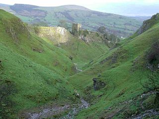
Cave Dale is a dry limestone valley in the Derbyshire Peak District, England. It is located at grid reference SK149824. The northern end of the dale starts at the village of Castleton where the valley sides are almost perpendicular and over 50 metres (160 ft) in height. The dale rises gently after leaving Castleton for approximately 200 metres (220 yd) before becoming steeper culminating in a fine viewpoint down the dale taking in Peveril Castle with Lose Hill behind. After the viewpoint the dale swings west and levels out with gentle gradients, becoming just a shallow depression as it peters out onto the open pastureland between Castleton and Chapel-en-le-Frith.

<span class="mw-page-title-main">Odin Mine</span> Disused lead mine in Derbyshire, England

Odin Mine is a disused lead mine in the Peak District National Park, situated at grid reference SK133835. It lies on a site of 25 hectares near the village of Castleton, England. It is the oldest documented mine in Derbyshire and is thought to be one of the oldest lead mines in England. The mine is a Scheduled Ancient Monument and has biological and geological significance within the Castleton Site of Special Scientific Interest.

<span class="mw-page-title-main">Great Rocks Dale</span> Dry valley used for quarrying in the Derbyshire Peak District

Great Rocks Dale is a dry valley in the Derbyshire Peak District, known for its extensive quarrying.

<span class="mw-page-title-main">Blue John (mineral)</span> Form of fluorite and semi-precious mineral

Blue John is a semi-precious mineral, a rare form of fluorite with bands of a purple-blue or yellowish colour. In the UK it is found only at Blue John Cavern and Treak Cliff Cavern at Castleton in Derbyshire. During the 19th century, it was mined for its ornamental value, and mining continues on a small scale.

Some Gritstone Climbs is a rock climbing guidebook written by British lawyer John Laycock (1887–1960). The book's subtitle, included uniquely on the frontispiece, is Some Shorter Climbs . It was published in Manchester in 1913 by the Refuge Printing Department. Although focusing on rock climbing in the Peak District, it covers several adjacent cliffs outside this region, and despite its title, referring to the Millstone Grit geology of many of the cliffs, it includes several cliffs consisting of other rock types, including mountain limestone and red sandstone.

<span class="mw-page-title-main">Buxton lime industry</span> History of the lime industry in Buxton, Derbyshire

The Buxton lime industry has been important for the development of the town of Buxton in Derbyshire, England, and it has shaped the landscape around the town.

<span class="mw-page-title-main">Middleton Dale</span> Valley in the Derbyshire Peak District

Middleton Dale is a steep-sided, carboniferous limestone valley in the Derbyshire Peak District of England. The village of Stoney Middleton lies at the eastern foot of the dale and the village of Eyam lies about 600 metres (660 yd) to the north, through the side valley of Eyam Dale. The dale is cut into the surrounding gritstone uplands of Middleton Moor and Eyam Moor. Dale Brook stream runs down the dale into Stoke Brook and on into the River Derwent 1.5 kilometres (1 mi) beyond Stoney Middleton. The Delf is a secluded, wooded side gorge with a stream between Eyam and Middleton Dale. Opposite The Delf, water gushes from Hawkenedge Well and flows into Dale Brook.

<span class="mw-page-title-main">Wye Valley, Derbyshire</span> Valley in the Derbyshire Peak District

The Wye Valley is the limestone valley of the River Wye in the White Peak of Derbyshire, England. The source of the River Wye is west of Buxton on Axe Edge Moor. One main channel runs underground through Poole's Cavern. The river flows though Buxton Pavilion Gardens and then along a culvert under the town centre. After leaving the flat area of central Buxton, the Wye Valley becomes distinct as a gorge running east for 10 miles (16 km) before the valley broadens at Ashford-in-the Water.

The geology of the Peak District National Park in England is dominated by a thick succession of faulted and folded sedimentary rocks of Carboniferous age. The Peak District is often divided into a southerly White Peak where Carboniferous Limestone outcrops and a northerly Dark Peak where the overlying succession of sandstones and mudstones dominate the landscape. The scarp and dip slope landscape which characterises the Dark Peak also extends along the eastern and western margins of the park. Although older rocks are present at depth, the oldest rocks which are to be found at the surface in the national park are dolomitic limestones of the Woo Dale Limestone Formation seen where Woo Dale enters Wye Dale east of Buxton.

References

  1. 1 2 3 "The Peak District, Derbyshire | Regional Studies | Limestone landscapes | Geology of Britain | British Geological Survey (BGS)". www.bgs.ac.uk. Retrieved 20 April 2020.
  2. 1 2 3 4 Leach, John (1987). The Book of Buxton. Baracuda Books Limited. pp. 13–17. ISBN   0-86023-286-7.
  3. 1 2 "Peak District Geology". www.peakscan.freeuk.com. Retrieved 19 April 2020.
  4. 1 2 Hose, Thomas (2017). "The English Peak District (as a potential geopark)". Acta Geoturistica. 8: 32–49. doi: 10.1515/agta-2017-0004 . S2CID   134281131.
  5. OL1 Dark Peak Area (Map). 1:25000. Explorer. Ordnance Survey.
  6. OL24 White Peak Area (Map). 1:25000. Explorer. Ordnance Survey.
  7. Ford, Trevor (December 1999). "The Growth of Geological Knowledge in the Peak District". Mercian Geologist. 13: 161–190 via East Midlands Geological Society.
  8. Farey, John (1811). "GENERAL VIEW OF THE AGRICULTURE AND MINERALS OF DERBYSHIRE". Internet Archive. Retrieved 20 April 2020.
  9. "Wonders of the Peak – Buxton Museum & Art Gallery". www.wondersofthepeak.org.uk. Retrieved 19 April 2020.
  10. "Search the National Heritage List for England". historicengland.org.uk. Retrieved 19 April 2020.
  11. On Peak Rock, published by the British Mountaineering Council, first edition 1993, ISBN   0-903908-91-3
  12. Leach, John (1987). The Book of Buxton. Baracuda Books Limited. pp. 83–91. ISBN   0-86023-286-7.
  13. Thomas, Ian (September 2011). "A Building Stone Atlas of Derbyshire and the Peak National Park". British Geological Survey. Retrieved 20 April 2020.
  14. "Diabase: A dark-colored, fine-grained intrusive igneous rock". geology.com. Retrieved 20 April 2020.
  15. "Peak District Lead Mining". www.peakscan.freeuk.com. Retrieved 19 April 2020.
  16. "ECTON MINE EDUCATIONAL TRUST". ectonmine.com. Retrieved 20 April 2020.
  17. Historic England. "Copper mines on Ecton Hill (1021175)". National Heritage List for England . Retrieved 20 April 2020.
  18. Bramley, J.V. (1991). "Fluorspar Mining in Derbyshire" (PDF). Stoney Middleton Heritage Centre. Retrieved 16 April 2020.
  19. Ford, Trevor D. (2013). Treak Cliff Cavern and the story of Blue John Stone. Treak Cliff Cavern.