
Uttara Kannada is a district in the Indian state of Karnataka. Uttara Kannada District is a major coastal district of Karnataka, with the largest coastal district. It is bordered by the state of Goa and Belagavi District to the north, Dharwad District and Haveri District to the east, Shivamogga District, and Udupi District to the south, and the Arabian Sea to the west.
Malnad is a region in the state of Karnataka in India. Malenadu covers the western and eastern slopes of the Western Ghats or Sahyadri mountain range, and is roughly 100 kilometers in width.

Agumbe is a village situated in the Thirthahalli taluka of Shimoga district, Karnataka, India. It is nestled in the thickly forested Malenadu region of the Western Ghats mountain range. Owing to its high rainfall, it has received the epithet of "The Cherrapunji of South India", after Cherrapunji, one of the rainiest places in India.

Kumta is a town and taluk in the Uttara Kannada district of Karnataka, India. It is one of the important stations along the Konkan Railway line running between Mumbai and Mangalore.

Sirsi is a city in Uttara Kannada district of Karnataka state in India. It was also known as Kalyana Pattana during the Sonda Dynasty. It is a tourist destination with evergreen forest and waterfalls and is also a commercial centre. The main businesses around the city are mostly subsistence and agriculture-based. Areca nut or betel nut, locally known as Adike, is the primary crop grown in the nearby villages, making it one of the major trading centres for areca nut. The region is also known for spices such as cardamom, pepper, betel leaves, and vanilla. The major food crop is paddy.
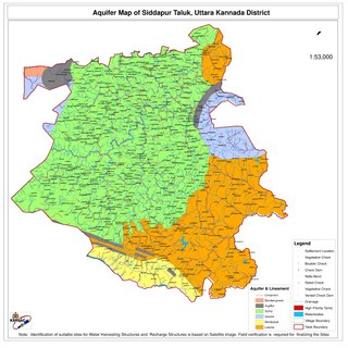
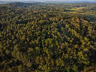
Siddapur Taluk is the destination of world famous Jog Falls. It is a part of Uttara Kannada district, Karnataka, India and is located in the midst of forest areas of Western Ghats and it is also a part of Malenadu. The taluk is full of greenery, hills and arecanut gardens developed in the valleys’. The taluk headquarters is Siddapur. Sirsi is the nearest city,

The Indian State of Karnataka is located between 11°30' North and 18°30' North latitudes and between 74° East and 78°30' East longitude.It is situated on a tableland where the Western Ghats and Eastern Ghats converge into the complex, in the western part of the Deccan Peninsular region of India. The State is bounded by Maharashtra and Goa States in the north and northwest; by the Lakshadweep Sea in the west; by Kerala in the south-west and Tamil Nadu in the south and south-east, Andhra Pradesh in the south-east and east and Telangana in the north-east. Karnataka extends to about 850 km (530 mi) from north to south and about 450 km (280 mi) from east to west.

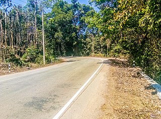
Ghat Roads are access routes into the mountainous Western and Eastern Ghats, mountain ranges of the Indian subcontinent. These roads are remarkable feats of engineering, and most were constructed during the British Raj. Ghat roads were built to connect to the hill stations established in the mountains for residents to avoid summer heat. They generally served to connect coastal (seaside) areas with the upper Deccan plateau of the Indian subcontinent.

Siddapura is a town and the headquarters of Siddapur taluk, It is located at a distance of 39 km (24 mi) from Sirsi through SH 93. it is part Uttara Kannada district in Karnataka. It is nestled among the Malenadu region. The town is surrounded by forests and lush greenery, and the region is popular for its many waterfalls.it is known for its proximity to Jog Falls, Adike is the primary crop grown in the villages that surround the town.

Charmadi Ghat (Charmady) is a Ghat in Belthangady taluk of Dakshina Kannada and Mudigere taluk of Chikkamagaluru. It is one of the points in Western ghats through which motorable road passes connecting Dakshina Kannada with Chikkamagaluru district. The section of ghat is known by the name of Charmadi Ghat. It lies on National Highway 73 which connects Mangaluru to Tumkuru. The nearest places are Charmadi village, Ujire, Belthangady, Puttur, Kottigehara, Balur and Kalasa Estate and Banakal.
Havigannada, also called as Havyaka Bhaashe and Havyaka Kannada, is the dialect of Kannada spoken in Malenadu and coastal region of Karnataka.

Tadadi (Tadari) is one of the ports in Uttara Kannada, Karnataka, India. It is near Gokarna in Kumta taluk.

Yana is a tourist destination located in forests of Malenadu region of Uttara Kannada district of Karnataka state in India. Yana is one of the wettest villages in the world. It is the cleanest village in Karnataka, and the second cleanest village in India. The two unique rock outcrops near the village are a tourist attraction and easily approachable by a small trek through 0.5 kilometres (0.31 mi) of thick forests from the nearest road head.
Sanikatta is a twin village in Kumta taluk of Uttara Kannada district, Karnataka, India. This place is about a few square kilometres in extent. It is in the neighborhood of Gokarna, Devarbhavi, Torke and Tadadi port. The place Sanikatta is the oldest salt-manufacturing village in the Karnataka State. Beginning from 1720, Sanikatta has continued manufacturing salt for nearly 300 years.
Charekone is a small village in Siddapura Taluk Uttara Kannada District, Karnataka State; Which is about 32 kilometres (20 mi) from Sirsi and 28 kilometres (17 mi) from Siddapur.

Hulikal is a village located in the Hosanagara taluk of the Shimoga district in the Indian state of Karnataka and is known for its heavy rainfall. The Hulikal village lies in western ghat region of Karnataka state. The range of ghat is known by the name Hulikal ghat or Balebare ghat. The road running between Hosangadi and Mastikatte through Hulikal ghati connects coastal district of Udupi with Shivamogga district. The Mani dam reservoir and Savehoklu reservoir are nearby. KPCL has its colony at Mastikatte near to Hulikal. The nearest airport is at Mangalore, situated 123 km south-west of Hulikal. It has an elevation of 600m.

Hegde is a village in Kumta on the western coast of India in the Uttara Kannada district of the state of Karnataka. Hegde is also the native of Mr. Ranjan Baleri who is an entrepreneur and philanthropist based in Bangalore.
Sampkhanda or Samphakanda is a Hill station of Western Ghats located in Sirsi Taluk of Uttara Kannada District, Karnataka, India. State Highway 69 passes through this village. It is 18 km (11 mi) away from Devimane Ghat and about 16 km (9.9 mi) from its Taluk Headquarters at Sirsi. Sampakhanda is considered one of the coldest places in Karnataka during summer season.
Vaddi is a village located in Uttara Kannada district of Ankola Taluk in Karnataka state of India. The road which passes through the village, State Highway 143 (SH143), is known as Vaddi Ghat. Vaddi Ghat lies in the heart of the Western Ghats between Sirsi and Ankola. Its average elevation is approximately 508 meters above sea level. The Rock Mountains of Yana are around three kilometers away from Vaddi village.

Vibhuthi Falls is located in Achave Gram panchayat,Ankola taluk of Uttara Kannada district in Karnataka, India. The word "Vibhuthi" means limestone. The water in this falls comes past limestone rocks near Yana and so the falls is called as "Vibhuthi Falls". Nearest towns near Vibhuthi falls are Sirsi, Kumta, Ankola, Gokarna.


