Doyle, Wisconsin

Last updated

Town of Doyle
WIMap-doton-Doyle.png
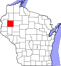
Location of the Town of Doyle
Coordinates: 45°30′52″N91°36′39″W / 45.51444°N 91.61083°W / 45.51444; -91.61083
Country Flag of the United States.svg  United States
State Flag of Wisconsin.svg  Wisconsin
County Barron
Area
  Total35.6 sq mi (92.3 km2)
  Land35.6 sq mi (92.3 km2)
  Water0.0 sq mi (0.0 km2)
Elevation
[1]
1,204 ft (367 m)
Population
 (2010)
  Total453
  Density13/sq mi (4.9/km2)
Time zone UTC-6 (Central (CST))
  Summer (DST) UTC-5 (CDT)
Area code(s) 715 & 534
FIPS code 55-20750 [2]
GNIS feature ID1583097 [1]

The Town [3] of Doyle is located in northeastern Barron County in the U.S. state of Wisconsin. The population was 453 at the 2010 census. [4] The unincorporated community of Horseman is located in the town. The unincorporated community of Campia is also located partially in the town.

Contents

History

The town was named for John J. Doyle, who was a former town chairman. [5]

Geography

Th Town of Doyle is located on the border with Rusk County. The western end of the Blue Hills occupies the southern half of the town, with the highest point rising to 1,622 feet (494 m), or about 400 feet (120 m) higher than the surrounding countryside.

According to the United States Census Bureau, the town has a total area of 35.6 square miles (92.3 km2), all of it land. [4]

Demographics

As of the census [2] of 2000, there were 498 people, 177 households, and 133 families residing in the town. The population density was 14.0 people per square mile (5.4/km2). There were 194 housing units at an average density of 5.4 per square mile (2.1/km2). The racial makeup of the town was 99.40% White, 0.20% Asian, and 0.40% from two or more races.

There were 177 households, out of which 37.9% had children under the age of 18 living with them, 65.0% were married couples living together, 7.3% had a female householder with no husband present, and 24.3% were non-families. 16.9% of all households were made up of individuals, and 7.9% had someone living alone who was 65 years of age or older. The average household size was 2.81 and the average family size was 3.27.

The population was 30.3% under the age of 18, 7.6% from 18 to 24, 29.7% from 25 to 44, 20.3% from 45 to 64, and 12.0% who were 65 years of age or older. The median age was 37 years. For every 100 females, there were 106 males. For every 100 females age 18 and over, there were 109 males.

The median income for a household in the town was $40,481, and the median income for a family was $41,827. Males had a median income of $29,844 versus $20,179 for females. The per capita income for the town was $16,014. About 6.7% of families and 10.1% of the population were below the poverty line, including 16.8% of those under age 18 and 4.3% of those age 65 or over.

Notable people

Related Research Articles

<span class="mw-page-title-main">Bear Lake, Wisconsin</span> Town in Wisconsin, United States

Bear Lake is a town in Barron County in the U.S. state of Wisconsin. The population was 659 at the 2010 census.

<span class="mw-page-title-main">Clinton, Barron County, Wisconsin</span> Town in Wisconsin, United States

Clinton is a town in Barron County, in the U.S. state of Wisconsin. The population was 879 at the 2010 census. The unincorporated community of Poskin is located in Clinton, along U.S. Route 8.

<span class="mw-page-title-main">Dovre, Wisconsin</span> Town in Wisconsin, United States

Dovre is a town in Barron County in the U.S. state of Wisconsin. The population was 849 at the 2010 census.

<span class="mw-page-title-main">Maple Grove, Barron County, Wisconsin</span> Town in Wisconsin, United States

The Town of Maple Grove is located in Barron County in the U.S. state of Wisconsin. The population was 979 at the 2010 census. The unincorporated community of Hillsdale is located in the town. The unincorporated community of Wickware is located partially in the town.

<span class="mw-page-title-main">Maple Plain, Wisconsin</span> Town in Wisconsin, United States

Maple Plain is a town in Barron County in the U.S. state of Wisconsin. The population was 803 at the 2010 census.

<span class="mw-page-title-main">Oak Grove, Barron County, Wisconsin</span> Town in Wisconsin, United States

Oak Grove is a town in Barron County in the U.S. state of Wisconsin. The population was 948 at the 2010 census. The unincorporated communities of Brill and Tuscobia are located in the town. The unincorporated community of Dobie is also located partially in the town.

<span class="mw-page-title-main">Stanfold, Wisconsin</span> Town in Wisconsin, United States

Stanfold is a town in Barron County in the U.S. state of Wisconsin. The population was 719 at the 2010 census.

Stanley is a town in Barron County in the U.S. state of Wisconsin. The population was 2,546 at the 2010 census. The town surrounds the village of Cameron but is separate from it.

<span class="mw-page-title-main">Sumner, Barron County, Wisconsin</span> Town in Wisconsin, United States

The Town of Sumner is located in Barron County in the U.S. state of Wisconsin. The population was 798 at the 2010 census. The unincorporated communities of Canton, Lehigh and Sumner are located in the town.

<span class="mw-page-title-main">Roosevelt, Burnett County, Wisconsin</span> Town in Wisconsin, United States

Roosevelt is a town in Burnett County in the U.S. state of Wisconsin. The population was 199 at the 2010 census. The unincorporated community of Timberland is located in the town.

<span class="mw-page-title-main">Auburn, Chippewa County, Wisconsin</span> Town in Wisconsin, United States

Auburn is a town in Chippewa County in the U.S. state of Wisconsin. The population was 697 at the 2010 census, up from 580 at the 2000 census.

<span class="mw-page-title-main">Montrose, Wisconsin</span> Town in Wisconsin, United States

The Town of Montrose is located in Dane County, Wisconsin, United States. The population was 1,134 at the 2000 census. The unincorporated communities of Basco and Paoli are located within the town.

<span class="mw-page-title-main">Harrison, Marathon County, Wisconsin</span> Town in Wisconsin, United States

The Town of Harrison is located in the northeast corner of Marathon County, Wisconsin, in the United States. It is part of the Wausau, Wisconsin Metropolitan Statistical Area. As of the 2010 census, the town population was 374. The unincorporated community of Snell is located in the town. The unincorporated community of Hogarty is also located partially in the town.

<span class="mw-page-title-main">Norrie, Wisconsin</span> Town in Wisconsin, United States

The Town of Norrie is located in Marathon County, Wisconsin, United States. It is part of the Wausau, Wisconsin Metropolitan Statistical Area. The population was 976 at the 2010 census.

Barron is a town in Barron County in the U.S. state of Wisconsin. The population was 873 at the 2010 census. The town surrounds the City of Barron.

Cumberland is a town in Barron County in the U.S. state of Wisconsin. The population was 876 at the 2010 census. The City of Cumberland is located partially within the town.

Dallas is a town in Barron County in the U.S. state of Wisconsin. As of the 2010 census, the town had a population of 565. The Village of Dallas is within the town.

Prairie Farm is a town in Barron County in the U.S. state of Wisconsin. The population was 573 at the 2010 census. The village of Prairie Farm is surrounded by the town.

Rice Lake is a town in Barron County in the U.S. state of Wisconsin. The population was 3,041 at the 2010 census. The City of Rice Lake is located mostly within the town. The unincorporated communities of Campia and Dobie are located partially in the town.

Turtle Lake is a town in Barron County, Wisconsin, United States. The population was 624 at the 2010 census. The Village of Turtle Lake is located just north of the town. The unincorporated community of Twin Town is located partially in the town.

References

  1. 1 2 "US Board on Geographic Names". United States Geological Survey. October 25, 2007. Retrieved January 31, 2008.
  2. 1 2 "U.S. Census website". United States Census Bureau . Retrieved January 31, 2008.
  3. "Towns" in Wisconsin perform most of the same functions as townships in many other states. see 'Wisconsin Blue Book 2022,' Town, pp 354-355
  4. 1 2 "Geographic Identifiers: 2010 Demographic Profile Data (G001): Doyle town, Barron County, Wisconsin". U.S. Census Bureau, American Factfinder. Archived from the original on February 12, 2020. Retrieved May 6, 2014.
  5. Callary, Edward. Place Names of Wisconsin. Madison, WI: University of Wisconsin Press. p. 78. ISBN   978-0-299-30964-0.
  6. 'Wisconsin Blue Book 1960,' Biographical Sketch of George Mireau, pg. 31