East San Fernando Light Rail Transit Project

Last updated

East San Fernando Light Rail Transit Project
LAMetroLogo.svg
Overview
StatusPlanned
Locale San Fernando Valley
Termini
Stations14
Service
Type Light rail
System Metro
History
Planned openingJune 2028 (2028-06) (G Line to Van Nuys/San Fernando)
Technical
Line length9.2 mi (14.8 km)
Number of tracks2
Character median-running at grade
Track gauge 1,435 mm (4 ft 8+12 in) standard gauge
Electrification Overhead line,  750 V DC
Route map

Contents

BSicon dCONTg.svg
BSicon uexdKINTa-L.svg
BSicon dBHF.svg
BSicon exdINT-R.svg
Sylmar/San Fernando
Metrolink icon.svg
BSicon uexdHST.svg
BSicon dSTR.svg
Maclay
BSicon WASSERq.svg
BSicon lvMKRZo-.svg
BSicon lv-MKRZo.svg
BSicon uexdSTR.svg
BSicon v-STR.svg
BSicon WASSERq.svg
BSicon dWASSERq.svg
BSicon dRP4q.svg
BSicon uemvSKRZ-G4u.svg
BSicon dRP4q.svg
BSicon uexdHST.svg
BSicon dSTR.svg
Paxton
BSicon uexdSTR.svg
BSicon CONT2+g.svg
Metrolink icon.svg
BSicon uexENDE.svg
Arrow Blue Up 001.svg Phase 2
Arrow Blue Down 001.svg Phase 1 (2028)
BSicon uexHST.svg
Van Nuys/San Fernando
BSicon uexHST.svg
Laurel Canyon
BSicon dRP4q.svg
BSicon uexSKRZ-G4u.svg
BSicon dRP4q.svg
I-5 (1961).svg I-5
BSicon uexHST.svg
Arleta
BSicon WASSERq.svg
BSicon uexWBRUCKE1.svg
BSicon dWASSERq.svg
BSicon uexHST.svg
Woodman
BSicon uexHST.svg
Nordhoff
BSicon uexHST.svg
Roscoe
BSicon CONTgq.svg
BSicon STRq.svg
BSicon lvBHF.svg
BSicon uexvKBHFa-BHF.svg
BSicon CONTfq.svg
Saticoy Street
BSicon LOGO Amtrak2.svg Metrolink icon.svg
BSicon uexdCONTf.svg
BSicon uexdSTR.svg
BSicon WASSERq.svg
BSicon uexWBRUCKE1.svg
BSicon dWASSERq.svg
BSicon uexHST.svg
Sherman Way
BSicon uexHST.svg
Vanowen
BSicon uexHST.svg
Victory
BSicon exlINT-Rq.svg
BSicon uexKINTe.svg
Van Nuys
BSicon uhCONTgq.svg
BSicon uhBHFq.svg
BSicon exlINT-Lq.svg
BSicon uhCONTfq.svg
LACMTA Square G Line.svg  
Detailed diagram
BSicon dCONTg.svg
Metrolink icon.svg
Sylmar/San Fernando
BSicon uexdKINTa-L.svg
BSicon dBHF.svg
BSicon exdINT-R.svg
Maclay
BSicon uexdHST.svg
BSicon dSTR.svg
BSicon WASSERq.svg
BSicon lvMKRZo-.svg
BSicon lv-MKRZo.svg
BSicon uexdSTR.svg
BSicon v-STR.svg
BSicon WASSERq.svg
BSicon dWASSERq.svg
BSicon dRP4q.svg
BSicon uemvSKRZ-G4u.svg
Paxton
BSicon MFADEg.svg
BSicon RP4.svg
BSicon uexdHST.svg
BSicon CONT2+g.svg
Metrolink icon.svg
BSicon RP4l.svg
BSicon uexBUE-us.svg
BSicon RP4q.svg
BSicon RP4+r.svg
Van Nuys/San Fernando
BSicon uexHST.svg
BSicon RP4.svg
BSicon uexSTR.svg
BSicon vRP2yRP4+l.svg
BSicon RP4wensRP4.svg
Laurel Canyon
BSicon vRP2HST.svg
BSicon uexHST.svg
BSicon dRP4q.svg
BSicon uexSTR.svg
BSicon MSTRq.svg
BSicon uexSKRZ-G4h.svg
BSicon vRP2.svg
BSicon dRP4q.svg
I-5 (1961).svg I-5
Arleta
BSicon vRP2HST.svg
BSicon uexHST.svg
BSicon WASSERq.svg
BSicon uexSTR.svg
BSicon vRP2oW.svg
BSicon dWASSERq.svg
Woodman
BSicon vRP2HST.svg
BSicon uexHST.svg
BSicon exCONTgq.svg
BSicon exSTR+r.svg
BSicon uexSTR.svg
BSicon vRP2.svg
Nordhoff
BSicon vRP2HST.svg
BSicon uexHST.svg
Roscoe
BSicon vRP2HST.svg
BSicon uexHST.svg
BSicon LOGO Amtrak2.svg Metrolink icon.svg
Saticoy Street
BSicon CONTgq.svg
BSicon uexKBHFa.svg
BSicon exlBHF-L.svg
BSicon STRq.svg
BSicon uexSTR.svg
BSicon STRq.svg
BSicon exlBHF-R.svg
BSicon BHFq.svg
BSicon vRP2.svg
BSicon CONTfq.svg
BSicon uexdCONTf.svg
BSicon uexSTR.svg
BSicon vRP2.svg
BSicon uexKDSTaq.svg
BSicon uexABZgr+r.svg
BSicon vRP2.svg
maintenance and
storage yard
BSicon WASSERq.svg
BSicon uexSTR.svg
BSicon vRP2oW.svg
BSicon dWASSERq.svg
BSicon exCONTgq.svg
BSicon exSTR+r.svg
BSicon uexSTR.svg
BSicon vRP2.svg
Sherman Way
BSicon vRP2HST.svg
BSicon uexHST.svg
Vanowen
BSicon vRP2HST.svg
BSicon uexHST.svg
Victory
BSicon vRP2HST.svg
BSicon uexHST.svg
BSicon uexSTR.svg
BSicon vRP2yRP42.svg
LACMTA Square G Line.svg  
Van Nuys
BSicon exlINT-Rq.svg
BSicon uexKINTe.svg
BSicon uhCONTgq.svg
BSicon exlINT-Lq.svg
BSicon uhBHFq.svg
BSicon exSTR.svg
BSicon uhCONTfq.svg
BSicon exCONTf.svg

The East San Fernando Light Rail Transit Project (formerly the East San Fernando Valley Transit Corridor Project) is a proposed light rail transit corridor in Los Angeles's San Fernando Valley, running on a north/south route along Van Nuys Boulevard and San Fernando Road. [1] Metro selected its preferred route as light rail without tunneling, "Alternative Six". The final Environmental Impact Report is currently in progress and the light rail line is scheduled for construction in mid 2023 with a completion of 2028. [2] [3]

The project is being planned by the Los Angeles County Metropolitan Transportation Authority (Metro). The line has been given high priority by Metro in its long range plan, and funding for the project is included in Measure R and Measure M. [4] [5] The project's timeline was accelerated under the Twenty-eight by '28 initiative. [6]

In June 2018, Metro staff recommended the corridor be built as an at-grade rail line, making it a part of the Los Angeles Metro Rail system. [1] In December 2020, Metro approved the Final EIR with the option to build the rail line in segments. [7]

Overview

Rail system map included in the official 1980 Proposition A election pamphlet - the corridor is seen at the upper left Los Angeles County Proposition A rail rapid transit system map.png
Rail system map included in the official 1980 Proposition A election pamphlet – the corridor is seen at the upper left

The northern end of the proposed line is Sylmar/San Fernando Station, providing a connection to the Metrolink Antelope Valley Line, and the southern end would be the G Line's Van Nuys Station. [8] An important intermediary stop would be at the currently existing Van Nuys Metrolink and Amtrak station, where passengers could transfer to the Ventura County Line, Amtrak routes, and the proposed Sepulveda Pass Transit Corridor to the Westside. The Metro staff recommendation included 14 stations for the 9.2-mile (14.8 km) line. [9]

The Pacific Electric San Fernando Line ran a north-south line between Downtown Los Angeles and San Fernando, partially on Van Nuys Avenue, from 1911 to 1952 before being dismantled and converted to bus service. The project route was portrayed in the project map included in the 1980 Proposition A documentation. Metro Rapid bus lines that serve the route as of 2022 are route 761 on Van Nuys Boulevard, with additional Metro Local lines supplementing both. Planning for the line will take into consideration other major planned infrastructure projects, including a Sepulveda Pass Transit Corridor rail link and the conversion of the G Line from bus rapid transit to light rail.

The Draft Environmental Impact Report was completed and released in September 2017, [10] and the final clearance was granted by the Federal Transit Administration in February 2021. [11]

History

Six initial alternatives were developed during the environmental review process: [10]

DEIR AlternativeDescriptionNew trips [12] Estimated cost
(billions) [12]
Alternative 1No buildN/AN/A
Alternative 2Transportation system managementN/AN/A
Alternative 3Curb-running bus rapid transit (BRT)30,900$0.294
Alternative 4Median-running BRT31,500$0.402
Alternative 5Median-running light rail transit (LRT) with low-floor vehicles35,800$1.3
Alternative 6Median-running LRT with high platform stations and some underground portions47,400$2.79

Route Selection: Alternative Six

In June 2018, Metro staff recommended a modified version of Alternative 6, using high-floor light rail vehicles like those on other Metro Rail lines but entirely on the street and entirely at-grade. The underground section between Sherman Way and Roscoe stations was eliminated, due to high costs of tunneling. [13]

Metro approved the project with $1.3 billion in funds, initiating the final EIR. The northern terminus will be the Sylmar/San Fernando Metrolink station. The light rail train will run southeast for two and a half miles on San Fernando Road to Van Nuys Boulevard. It then heads south on Van Nuys Boulevard for five miles (8.0 km) reaching the Van Nuys Metrolink station. Its southern terminus will be the Van Nuys G Line station near L.A.'s Van Nuys City Hall two miles (3.2 km) further south. [14]

PhaseDate openingStationCity/NeighborhoodConnecting services [15]
TwoTBA Sylmar/San Fernando Sylmar Metrolink icon.svg Metrolink: Antelope Valley
Maclay San Fernando
Paxton Pacoima
OneJune 2028 [2] Van Nuys/San Fernando
Laurel Canyon
Arleta Arleta
Woodman
Nordhoff Panorama City
Roscoe
Saticoy Street
Van Nuys Metrolink/Amtrak
Van Nuys BSicon LOGO Amtrak2.svg Amtrak: Pacific Surfliner & Coast Starlight ,
Metrolink icon.svg Metrolink: Ventura County
Possible future terminus of the Sepulveda Pass Transit Corridor [16]
Sherman Way
Vanowen
Victory
Van Nuys LACMTA Square G Line.svg  G Line

Construction

The line is planned to be built in two phases: the first running from the Van Nuys G Line station to San Fernando Road with the remaining segment to be completed later. [11] [17] Groundbreaking is scheduled for mid 2023 with operations anticipated to begin in 2028 or 2030. [18] [2] Funds were being acquired by 2020, with $800 million coming from Measure M, $200 million from Road Repair and Accountability Act gas tax, and $200 million from other state-level sources. [19] The Federal Transit Administration intends to provide $909 million between 2022 and 2023 to fund the project. [2] The capital project cost for the first phase is estimated to be $3.635 billion. [20]

Related Research Articles

<span class="mw-page-title-main">San Fernando Valley</span> Large populated valley in Los Angeles County, California, US

The San Fernando Valley, known locally as the Valley, is an urbanized valley in Los Angeles County, California. Located just north of the Los Angeles Basin, it contains a large portion of the City of Los Angeles, as well as unincorporated areas and the incorporated cities of Burbank, Calabasas, Glendale, Hidden Hills, and San Fernando. The valley is well known for its iconic film studios such as Warner Bros. Studio and Walt Disney Studios. In addition, it is home to the Universal Studios Hollywood theme park.

<span class="mw-page-title-main">Los Angeles County Metropolitan Transportation Authority</span> Public transportation agency in Los Angeles, CA

The Los Angeles County Metropolitan Transportation Authority (LACMTA), commonly branded as Metro or L.A. Metro, is the agency that plans, operates, and coordinates funding for most of the transportation system in Los Angeles County. The agency directly operates a large transit system that includes bus, light rail, heavy rail (subway), and bus rapid transit services; and provides funding for transit it does not operate, including Metrolink commuter rail, municipal bus operators and paratransit services. Metro also provides funding and directs planning for railroad and highway projects within Los Angeles County. In 2021, the system had a total ridership of 227,718,700 and had a ridership of 781,800 per weekday as of the second quarter of 2022.

<span class="mw-page-title-main">Antelope Valley Line</span> Metrolink commuter rail line linking Downtown Los Angeles to Northern Los Angeles County

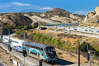
The Antelope Valley Line is a commuter rail line that serves the Northern Los Angeles County area as part of the Metrolink system. The northern segment of the line is rural in character because it travels through the sparsely populated Soledad Canyon between Santa Clarita and Palmdale, serving the small community of Acton along the way. Other portions of its route parallel the former US Route 6, now San Fernando Road and Sierra Highway and this line is the only Metrolink line to be entirely in Los Angeles County.

<span class="mw-page-title-main">Los Angeles Metro Rail</span> Urban rail system serving Los Angeles County, California, United States

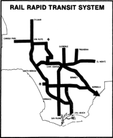
The Los Angeles Metro Rail is an urban rail transportation system serving Los Angeles County, California, United States. It consists of seven lines, including five light rail lines and two rapid transit lines serving 99 stations. It connects with the Metro Busway bus rapid transit system, the Metrolink commuter rail system, and several Amtrak lines.

<span class="mw-page-title-main">Van Nuys station (Los Angeles Metro)</span> Rapid-transit bus stop in San Fernando Valley, Los Angeles, California

Van Nuys station is a station on the G Line of the Los Angeles Metro Busway system. It is named after adjacent Van Nuys Boulevard, which travels north-south and crosses the east-west busway route and is located in the Van Nuys district of Los Angeles, in the San Fernando Valley. Adjacent to the station is the G Line's bicycle path.

<span class="mw-page-title-main">Van Nuys station</span> Railway station in Van Nuys, California

Van Nuys station is an Amtrak and Metrolink train station in the Van Nuys neighborhood of Los Angeles, California. Amtrak's Pacific Surfliner from San Luis Obispo to San Diego, Amtrak's Coast Starlight from Los Angeles to Seattle, Washington, and Metrolink's Ventura County Line from Los Angeles Union Station to East Ventura stop here.

<span class="mw-page-title-main">Sylmar/San Fernando station</span> Metrolink stop in the northeast San Fernando Valley

Sylmar/San Fernando station is a Metrolink rail station located in Sylmar, California, and adjacent to the city of San Fernando. It is served by Metrolink's Antelope Valley Line between Los Angeles Union Station and Lancaster.

<span class="mw-page-title-main">Gold Line Foothill Extension</span> Northeastern extension of the Los Angeles Metro Gold Line

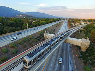
The Gold Line Foothill Extension is an extension of the Metro Gold Line light rail corridor from its former terminus in Pasadena, California, east through the "Foothill Cities" of Los Angeles County. The first stage of the plan, Phase 2A, extended the Gold Line from Pasadena to Azusa; it opened on March 5, 2016. Phase 2B, which will extend the line a further four stations to Pomona—North, broke ground in December 2017.

<span class="mw-page-title-main">Sepulveda Pass Transit Corridor</span> Planned transit area in Los Angeles, California

The Sepulveda Pass Transit Corridor is a two-phased planned transit corridor connecting the Los Angeles Basin to the San Fernando Valley through the Sepulveda Pass in Los Angeles, California, by supplementing the existing freeway. The corridor would partly parallel I-405, and proposed alternatives include a rapid transit (subway) or a monorail line connecting the G Line in the Valley to the D Line and E Line on the Westside, and the K Line near Los Angeles International Airport.

Maclay is a planned light rail station on the Los Angeles County Metro Rail system. The station is part of the East San Fernando Light Rail Project. It is located on North Maclay Avenue near the intersection with Truman Street in San Fernando, California. Metrolink Antelope Valley Line trains pass but will not stop here. It is planned to open as part of the second phase of the project.

Paxton is a planned light rail station on the Los Angeles County Metro Rail system. The station is part of the East San Fernando Light Rail Project. It is located on San Fernando Road between the base of the northbound California State Route 118 interchange and the intersection with Paxton Street in Pacoima. Metrolink Antelope Valley Line trains pass but will not stop here. It is planned to open as part of the second phase of the project.

Victory is a planned light rail station on the Los Angeles County Metro Rail system. The station is part of the East San Fernando Light Rail Project and planned to open in 2028. It is located on Van Nuys Boulevard at the intersection with Victory Boulevard in the Van Nuys neighborhood of Los Angeles. The station is a split design, with the northbound platform on the north side of the intersection and the southbound platform the opposite.

Vanowen is a planned light rail station on the Los Angeles County Metro Rail system. The station is part of the East San Fernando Light Rail Project and planned to open in 2028. It is located on Van Nuys Boulevard at the intersection with Vanowen Street in the Van Nuys neighborhood of Los Angeles. The station is a split design, with the northbound platform on the north side of the intersection and the southbound platform the opposite.

Arleta is a planned light rail station on the Los Angeles County Metro Rail system. The station is part of the East San Fernando Light Rail Project and planned to open in 2028. It is located on Van Nuys Boulevard at the intersection with Arleta Boulevard in the Arleta neighborhood of Los Angeles. The station features a single island platform in the median strip on the southwest leg of the crossroads.

Van Nuys/San Fernando is a planned light rail station on the Los Angeles County Metro Rail system. The station is part of the East San Fernando Light Rail Project. It is located near the corners of Van Nuys Boulevard and El Dorado Way, near San Fernando Road in Pacoima. The station is expected to open in 2028 as the interim northern terminus of the line until service is extended to Sylmar/San Fernando station.

Sherman Way is a planned light rail station in the Los Angeles County Metro Rail system. The station is part of the East San Fernando Light Rail Project and planned to open in 2028. It is located on Van Nuys Boulevard at the intersection with Sherman Way in the Van Nuys neighborhood of Los Angeles.

Laurel Canyon is a planned light rail station in the Los Angeles County Metro Rail system. The station is part of the East San Fernando Light Rail Project and planned to open in 2028. It is located in Arleta, California and features an island platform on the north side of on Van Nuys Boulevard at the intersection with Laurel Canyon Boulevard.

Roscoe is a planned light rail and bus rapid transit station in the Los Angeles County Metro Rail system. The station is part of the East San Fernando Light Rail Project and is planned to open in 2028 It is located on Van Nuys Boulevard at the intersection with Roscoe Boulevard in the Panorama City neighborhood of Los Angeles.

Woodman is a planned light rail station on the Los Angeles County Metro Rail system. The station is part of the East San Fernando Light Rail Project and planned to open in 2028. It is located on Van Nuys Boulevard at the intersection with Woodman Boulevard in the Arleta neighborhood of Los Angeles. The station features a single island platform in the median strip on the northeast leg of the crossroads.

Nordhoff is a planned light rail station on the Los Angeles County Metro Rail system. The station is part of the East San Fernando Light Rail Project and planned to open in 2028. It is located on Van Nuys Boulevard at the intersection with Nordhoff Street in the Panorama neighborhood of Los Angeles. The station features a single island platform in the median strip on the north leg of Van Nuys.

References

  1. 1 2 Chiland, Elijah (June 28, 2018). "Metro greenlights new light rail line in the San Fernando Valley". CurbedLA. Retrieved August 29, 2020.
  2. 1 2 3 4 Scauzillo, Steve (May 27, 2022). "East San Fernando Valley rail line project gets $909 million boost from Feds". Los Angeles Daily News. Retrieved July 26, 2022.
  3. "Public comment begins on L.A. Metro's FEIS/R for LRT project between Van Nuys and San Fernando". Mass Transit. Los Angeles County Metropolitan Transportation Authority. October 5, 2020. Retrieved October 19, 2020.{{cite magazine}}: Cite magazine requires |magazine= (help)
  4. "East San Fernando Valley Transit Corridor". www.metro.net. Retrieved February 2, 2019.
  5. "Draft EIS/EIR". www.metro.net. Retrieved February 2, 2019.
  6. Sharp, Steven (November 27, 2018). "Here are the 28 Projects that Metro Could Complete Before the 2028 Olympics". Urbanize. Retrieved July 2, 2018.
  7. Sotero, Dave (December 3, 2020). "Metro Board approves Final EIR for East San Fernando Valley Light Rail Transit Project". The Source. Retrieved December 4, 2020.
  8. Draft Environmental Impact Statement/Draft Environmental Impact Report for the East San Fernando Valley Transit Corridor (PDF), U.S. Department of Transportation and the Los Angeles County Metropolitan Transportation Authority, August 2017
  9. "ESFVTC: Alignment Map, Station Locations & Project Description".
  10. 1 2 "The East San Fernando Valley Transit Corridor: Rendered". Urbanize LA. November 17, 2014. Retrieved February 2, 2019.
  11. 1 2 "FTA environmentally clears L.A. Metro's East San Fernando Valley light-rail transit project" (Press release). Mass Transit. Los Angeles County Metropolitan Transportation Authority. February 2, 2021. Retrieved February 2, 2021.
  12. 1 2 "East San Fernando Valley Transit Corridor Takes Another Step Towards Reality". Urbanize LA. September 1, 2017. Retrieved February 2, 2019.
  13. Hymon, Steve (June 16, 2018). "Metro staff recommends building light rail between Van Nuys and Sylmar/San Fernando Metrolink Station". metro.net. Retrieved February 2, 2019.
  14. "L.A. Metro Board Approves Light Rail for East San Fernando Valley Transit Corridor Project". www.MassTransitMag.com. Retrieved February 2, 2019.
  15. "Bus and Rail System Map" (PDF). Los Angeles County Metropolitan Transportation Authority. Retrieved December 3, 2018.
  16. Hymon, Steve (January 29, 2019). "Here are the four new refined concepts for Sepulveda Transit Corridor". metro.net. Retrieved February 2, 2019.
  17. "East San Fernando Valley Light Rail Project Now Eligible For Federal Funding". MyNewsLA.com. February 1, 2021. Retrieved February 2, 2021.
  18. https://www.metro.net/projects/east-sfv/
  19. Sharp, Steven (June 18, 2018). "Metro Staff Recommends Light Rail for Van Nuys Boulevard". Urbanize LA. Retrieved August 27, 2020.
  20. "U.S. Department of Transportation Announces Path Forward for Los Angeles County Metropolitan Transportation Authority's East San Fernando Valley Transit Corridor Phase I Project Under the Expedited Project Delivery Pilot Program". Federal Transit Administration. Retrieved June 3, 2022.

Route map:

Template:Attached KML/East San Fernando Light Rail Transit Project
KML is not from Wikidata