Edwards, Mississippi | |
---|---|
Coordinates: 32°19′51″N90°36′15″W / 32.33083°N 90.60417°W | |
Country | United States |
State | Mississippi |
County | Hinds |
Area | |
• Total | 1.66 sq mi (4.30 km2) |
• Land | 1.66 sq mi (4.30 km2) |
• Water | 0.00 sq mi (0.00 km2) |
Elevation | 236 ft (72 m) |
Population (2020) | |
• Total | 995 |
• Density | 599.40/sq mi (231.42/km2) |
Time zone | UTC-6 (Central (CST)) |
• Summer (DST) | UTC-5 (CDT) |
ZIP code | 39066 |
Area code | 601 |
FIPS code | 28-21580 |
GNIS feature ID | 0669683 |
Website | townofedwards |
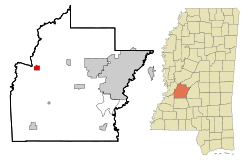
Edwards is a town in Hinds County, Mississippi, United States. The population was 1,034 at the 2010 census, [2] down from 1,347 at the 2000 census. It is part of the Jackson Metropolitan Statistical Area.
Edwards is named for Dick Edwards, owner and proprietor of the Edwards House in Jackson, Mississippi. [3]
Edwards was originally named "Amsterdam" and settled in the 1830s. In 1832, it suffered from a cholera epidemic and was then bypassed by the Alabama and Vicksburg Railroad. This happened in 1839 when R. O. Edwards' plantation became a stop on the railroad known as Edwards Depot.
The depot was burned to prevent its use during the Civil War in 1863. The current site of Edwards was chosen in 1866 and was incorporated in 1871.
In 1882, the Southern Christian Institute was opened by the Christian Church (Disciples of Christ) in the town to educate African Americans. It later became Bonner-Campbell College. In 1897, Edwards suffered an attack of yellow fever that killed many residents of the town. [4]
Edwards is in western Hinds County, on high ground 1.5 miles (2.4 km) east of the Big Black River, which forms the Warren County line. Interstate 20 runs along the northern border of the town, with access from Exit 19. I-20 leads east 26 miles (42 km) to Jackson, the state capital, and west 17 miles (27 km) to Vicksburg.
According to the United States Census Bureau, the town of Edwards has a total area of 1.7 square miles (4.3 km2), all land. [2]
Census | Pop. | Note | %± |
---|---|---|---|
1900 | 586 | — | |
1910 | 589 | 0.5% | |
1920 | 727 | 23.4% | |
1930 | 456 | −37.3% | |
1940 | 1,110 | 143.4% | |
1950 | 1,002 | −9.7% | |
1960 | 1,206 | 20.4% | |
1970 | 1,236 | 2.5% | |
1980 | 1,515 | 22.6% | |
1990 | 1,279 | −15.6% | |
2000 | 1,347 | 5.3% | |
2010 | 1,034 | −23.2% | |
2020 | 995 | −3.8% | |
U.S. Decennial Census [5] |
Race | Num. | Perc. |
---|---|---|
White | 109 | 10.95% |
Black or African American | 843 | 84.72% |
Native American | 2 | 0.2% |
Asian | 1 | 0.1% |
Other/Mixed | 20 | 2.01% |
Hispanic or Latino | 20 | 2.01% |
As of the 2020 United States Census, there were 995 people, 404 households, and 193 families residing in the town.
As of the 2010 United States Census, there were 1,034 people living in the town. The racial makeup of the town was 82.4% Black, 15.4% White, 0.7% Native American, 0.1% Asian and 0.6% from two or more races. 0.9% were Hispanic or Latino of any race.
As of the census [7] of 2000, there were 1,347 people, 461 households, and 335 families living in the town. The population density was 808.2 inhabitants per square mile (312.0/km2). There were 505 housing units at an average density of 303.0 per square mile (117.0/km2). The racial makeup of the town was 78.92% African American, 20.19% White, 0.15% Asian, 0.07% from other races, and 0.67% from two or more races. Hispanic or Latino of any race were 0.97% of the population.
There were 461 households, out of which 32.1% had children under the age of 18 living with them, 32.5% were married couples living together, 33.0% had a female householder with no husband present, and 27.3% were non-families. 23.0% of all households were made up of individuals, and 10.2% had someone living alone who was 65 years of age or older. The average household size was 2.90 and the average family size was 3.47.
In the town, the population was spread out, with 29.6% under the age of 18, 9.0% from 18 to 24, 27.8% from 25 to 44, 21.1% from 45 to 64, and 12.5% who were 65 years of age or older. The median age was 34 years. For every 100 females there were 82.3 males. For every 100 females age 18 and over, there were 75.6 males.
The median income for a household in the town was $29,231, and the median income for a family was $31,786. Males had a median income of $26,094 versus $19,500 for females. The per capita income for the town was $12,308. About 19.0% of families and 22.5% of the population were below the poverty line, including 32.4% of those under age 18 and 18.7% of those age 65 or over.
Edwards is served by the Hinds County School District and is zoned to Bolton/Edwards Elementary-Middle School in Bolton and Raymond High School in Raymond. [8]
Jackson/Hinds Library System operates the Lois A. Flagg Library in Edwards, adjacent to the Edwards Head Start Center. [9]
Warren County is a county located in the U.S. state of Mississippi. Its western border is formed by the Mississippi River. As of the 2020 census, the population was 44,722. Its county seat is Vicksburg. Established by legislative act of December 22, 1809, Warren County is named for American Revolutionary War officer Joseph Warren.
Killen is a town in Lauderdale County, Alabama, United States. It is part of the Florence - Muscle Shoals Metropolitan Statistical Area known as "The Shoals". It was incorporated in 1957. As of the 2020 census, the population of the town is 1,034, down from its record high of 1,119 in 2000.
Boyle is a town in Bolivar County, Mississippi, United States. The population was 650 at the 2010 census.
Renova is a town in Bolivar County, Mississippi, United States.Per the 2020 census, the population was 676. The community was founded by African Americans and remains predominantly African American.
Rosedale is a city in Bolivar County, Mississippi, United States. The population was 1,873 at the 2010 census, down from 2,414 in 2000. Located in an agricultural area, the city had a stop on the Yazoo and Mississippi Valley Railroad, which carried many migrants north out of the area in the first half of the 20th century.
Bruce is a town situated along the Skuna River in Calhoun County, Mississippi, United States. As of the 2020 census, it had a population of 1,707.
Hernando is the county seat of DeSoto County, on the northwestern border of Mississippi, United States. The population was 17,138 according to the 2020 census records. DeSoto County is the second-most-populous county in the Memphis metropolitan area, which includes counties in Tennessee, Arkansas and Mississippi.
Bolton is a town in Hinds County, Mississippi, United States. The population was 567 at the 2010 census, down from 629 at the 2000 census. It is part of the Jackson Metropolitan Statistical Area.
Learned is a town in Hinds County, Mississippi, United States.
Terry is a town in Hinds County, Mississippi, United States. The population was 1,063 at the 2010 census, up from 664 at the 2000 census. It is located along Interstate 55, about 15 miles (24 km) southwest of Jackson and located in Supervisors District Five of Hinds County. The town is part of the Jackson Metropolitan Statistical Area.
Utica is a town in Hinds County, Mississippi, United States. The population was 820 at the 2010 census, down from 966 at the 2000 census. Utica is part of the Jackson Metropolitan Statistical Area.
Goodman is a town in southeastern Holmes County, Mississippi, United States. Per the 2020 census, the population was 1,258.
Crawford is a small town in Lowndes County, Mississippi, United States. The population was 641 at the 2010 census.
Algoma is a town in Pontotoc County, Mississippi. The population was 705 at the 2020 census, up from 590 at the 2010 census.
Sledge is a town located in Quitman County, Mississippi, United States. As of the 2020 census, the town had a total population of 368.
Forest is a city and the county seat of Scott County, Mississippi, United States. The population was 5,684 at the 2010 census and the population is a minority-majority.
Doddsville is a town in Sunflower County, Mississippi. The population was 98 at the 2010 census. It was established by Daniel Doddsman Sr. in 1889.
Inverness is a town in Sunflower County, Mississippi, United States. The population was 1,019 at the 2010 census. As the town had the largest cotton gin in the Mississippi Delta, it served as a gathering place for farmers from the region when they brought their cotton for processing. The town was heavily damaged by a tornado in 1971.
Kosciusko is a city in Attala County, Mississippi, United States. The population was 7,402 at the 2010 census. It is the county seat of Attala County.
The Jackson–Vicksburg–Brookhaven, MS Combined Statistical Area is made up of eight counties in central Mississippi and consists of the Jackson Metropolitan Statistical Area, the Brookhaven, MS Micropolitan Statistical Area, the Vicksburg micropolitan area, and the Yazoo City Micropolitan Statistical Area. The 2010 census placed the Jackson–Vicksburg–Brookhaven CSA population at 650,764, although as of 2019, it's estimated to have increased to 666,318.