The National Hurricane Center (NHC) is the division of the United States' NOAA/National Weather Service responsible for tracking and predicting tropical weather systems between the Prime Meridian and the 140th meridian west poleward to the 30th parallel north in the northeast Pacific Ocean and the 31st parallel north in the northern Atlantic Ocean. The agency, which is co-located with the Miami branch of the National Weather Service, is situated on the campus of Florida International University in University Park, Miami, Florida.

The 1999 Atlantic hurricane season was a fairly active season, mostly due to a persistent La Niña that developed in the latter half of 1998. It had five Category 4 hurricanes – the highest number recorded in a single season in the Atlantic basin, previously tied in 1933 and 1961, and later tied in 2005 and 2020. The season officially began on June 1, and ended on November 30. These dates conventionally delimit the period of each year when most tropical cyclones form in the Atlantic basin. The first storm, Arlene, formed on June 11 to the southeast of Bermuda. It meandered slowly for a week and caused no impact on land. Other tropical cyclones that did not affect land were Hurricane Cindy, Tropical Storm Emily, and Tropical Depression Twelve. Localized or otherwise minor damage occurred from Hurricanes Bret, Gert, and Jose, and tropical storms Harvey and Katrina.

The 1996 Atlantic hurricane season had the most major hurricanes since 1950, which are Category 3 or higher on the Saffir-Simpson scale. The season was above-average, featuring a total of thirteen named storms, nine hurricanes, and six major hurricanes. The season officially began on June 1, 1996 and ended on November 30, 1996, dates which conventionally delimit the period of each year when most tropical cyclones form in the Atlantic basin. The season's first tropical cyclone, Tropical Storm Arthur, developed on June 17, while the final cyclone, Hurricane Marco dissipated on November 26. The most intense hurricane, Edouard, was a powerful Cape Verde-type hurricane that affected portions of the Mid-Atlantic states and New England. The season featured nine tropical cyclone landfalls, including six hurricanes, one of which was a major hurricane. In total, six major hurricanes formed during the 1996 Atlantic hurricane season—the highest number produced in a single season since 1950.

The 1960 Atlantic hurricane season was the least active season since 1952. The season officially began on June 15, and lasted until November 15. These dates conventionally delimit the period of each year when most tropical cyclones form in the Atlantic basin. The first system, an unnamed storm, developed in the Bay of Campeche on June 22. It brought severe local flooding to southeastern Texas and was considered the worst disaster in some towns since a Hurricane in 1945. The unnamed storm moved across the United States for almost a week before dissipating on June 29. In July, Hurricane Abby resulted in minor damage in the Leeward Islands, before impacting a few Central American counties — the remnants of the storm would go on to form Hurricane Celeste in the East Pacific. Later that month, Tropical Storm Brenda caused flooding across much of the East Coast of the United States. The next storm, Hurricane Cleo, caused no known impact, despite its close proximity to land.

The 1985 Atlantic hurricane season had six United States landfalling hurricanes, tied with 1886 and 2020 for the highest number on record. The season officially began on June 1 and lasted until November 30. It was an average season, with 11 named storms developing. This was partially attributed to a La Niña – a meteorological phenomenon that produces favorable conditions across the Atlantic basin, such as lower wind shear and higher sea surface temperatures. The first storm, Ana, developed on July 15 near Bermuda and caused minor effects in Canada while transitioning into an extratropical cyclone. Three other tropical cyclones – Claudette, Henri, and Isabel – did not significantly affect land. Claudette developed offshore of the Southeastern United States and brushed Bermuda and the Azores. Henri and Isabel were dissipating as they approached land. However, the precursor of the latter caused a severe flood in Puerto Rico that killed 180 people. Additionally, Tropical Storm Fabian and three tropical depressions did not have any known impact on land.
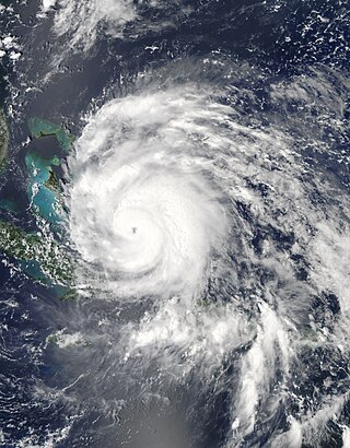
Hurricane Ivan was a large, long-lived, Cape Verde hurricane that caused widespread damage in the Caribbean and United States. The cyclone was the ninth named storm, the sixth hurricane and the fourth major hurricane of the active 2004 Atlantic hurricane season.

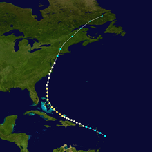
Hurricane Belle was a strong tropical cyclone that caused moderate damage across the East Coast of the United States in August 1976. In late July, a tropical wave emerged off the west coast of Africa. Traversing the Atlantic Ocean for more than a week, the system eventually consolidated into a tropical depression near the Bahamas on August 6. Remaining nearly stationary for a day, the depression strengthened into a tropical storm on August 7 and a hurricane later that day as it acquired a northwest motion. Formation of an eye accompanied quick intensification and Belle reached its peak the following day with winds of 120 mph (190 km/h). The hurricane subsequently turned north and accelerated, skirting the Outer Banks of North Carolina. Early on August 10, Belle made landfall on Long Island, New York, as a minimal hurricane crossing Long Island Sound and hitting the central coast of Connecticut as a strong tropical storm. Thereafter, Belle transitioned into an extratropical cyclone over New England before moving over Atlantic Canada. The system turned east while over the North Atlantic and ultimately dissipated on August 15 to the south of Iceland.

The 2003 Pacific hurricane season was the first season to feature no major hurricanes since 1977. The season officially began on May 15, 2003 in the Eastern North Pacific, and on June 1 in the Central ; both ended on November 30. These dates, adopted by convention, historically describe the period in each year when most tropical cyclogenesis occurs in these regions of the Pacific. The season featured 16 tropical storms, 7 of which intensified into hurricanes, which was then considered an average season. Damage across the basin reached US$129 million, and 23 people were killed by the storms.
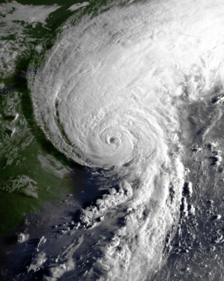
Hurricane Bob was one of the costliest hurricanes in New England history. The second named storm and first hurricane of the 1991 Atlantic hurricane season, Bob developed from an area of low pressure near The Bahamas on August 16. The depression steadily intensified, and became Tropical Storm Bob late on August 16. Bob curved north-northwestward as a tropical storm, but re-curved to the north-northeast after becoming a hurricane on August 17. As such, it brushed the Outer Banks of North Carolina on August 18 and August 19, and subsequently intensified into a major hurricane. After peaking in intensity with maximum sustained winds of 115 mph (185 km/h), Bob weakened slightly as it approached the coast of New England.
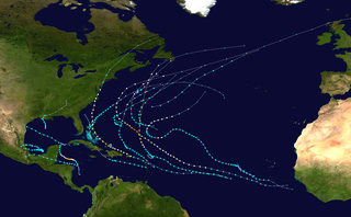
The 2011 Atlantic hurricane season was the second in a group of three very active Atlantic hurricane seasons, each with 19 named storms, only behind 1887, 1995, 2010, and 2012. The above-average activity was mostly due to a La Niña that persisted during the previous year. Of the season's 19 tropical storms, only seven strengthened into hurricanes, and four of those became major hurricanes: Irene, Katia, Ophelia, and Rina. The season officially began on June 1 and ended on November 30, dates which conventionally delimit the period during each year in which most tropical cyclones develop in the Atlantic Ocean. However, the first tropical storm of the season, Arlene, did not develop until nearly a month later. The final system, Tropical Storm Sean, dissipated over the open Atlantic on November 11.
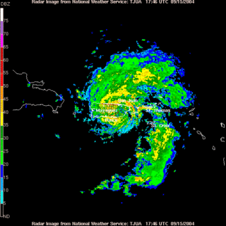
The effects of Hurricane Jeanne in Puerto Rico included the most damage from a tropical cyclone since Hurricane Georges in 1998. The tenth tropical storm of the 2004 Atlantic hurricane season, struck the U.S. territory of Puerto Rico on September 15 with 70 mph (110 km/h) winds. While crossing the island, the storm dropped heavy rainfall, peaking at 19.2 in (490 mm) at Aibonito, with a total of 23.75 in (603 mm) on the offshore island of Vieques. The rainfall caused widespread flooding, resulting in landslides and heavy crop damage. Winds reached 72 mph (116 km/h) at Cayey, and its combination with the rainfall left most of the island without power or water.
Hurricane Irene was a large and destructive tropical cyclone which affected much of the Caribbean and East Coast of the United States during late August 2011. The ninth named storm, first hurricane, and first major hurricane of the 2011 Atlantic hurricane season, Irene originated from a well-defined Atlantic tropical wave that began showing signs of organization east of the Lesser Antilles. Due to development of atmospheric convection and a closed center of circulation, the system was designated as Tropical Storm Irene on August 20, 2011. After intensifying, Irene made landfall in St. Croix as a strong tropical storm later that day. Early on August 21, the storm made a second landfall in Puerto Rico. While crossing the island, Irene strengthened into a Category 1 hurricane. The storm paralleled offshore of Hispaniola, continuing to slowly intensify in the process. Shortly before making four landfalls in the Bahamas, Irene peaked as a 120 mph (190 km/h) Category 3 hurricane.

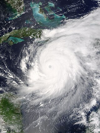
Hurricane Andrew was a compact, but very powerful and destructive Category 5 Atlantic hurricane that struck the Bahamas, Florida, and Louisiana in August 1992. It is the most destructive hurricane to ever hit Florida in terms of structures damaged or destroyed, and remained the costliest in financial terms until Hurricane Irma surpassed it 25 years later. Andrew was also the strongest landfalling hurricane in the United States in decades and the costliest hurricane to strike anywhere in the country, until it was surpassed by Katrina in 2005. In addition, Andrew is one of only four tropical cyclones to make landfall in the continental United States as a Category 5, alongside the 1935 Labor Day hurricane, 1969's Camille, and 2018's Michael. While the storm also caused major damage in the Bahamas and Louisiana, the greatest impact was felt in South Florida, where the storm made landfall as a Category 5 hurricane, with 1-minute sustained wind speeds as high as 165 mph (266 km/h) and a gust as high as 174 mph (280 km/h). Passing directly through the cities of Cutler Bay and Homestead in Dade County, the hurricane stripped many homes of all but their concrete foundations and caused catastrophic damage. In total, Andrew destroyed more than 63,500 houses, damaged more than 124,000 others, caused $27.3 billion in damage, and left 65 people dead.

The effects of Hurricane Sandy in New England spread as far north as Maine in late October 2012, with the most significant damage in Connecticut, and included hurricane-force gusts.

Hurricane Iselle was the strongest tropical cyclone to make landfall on the Big Island of Hawaii in recorded history. The tenth named storm, fifth hurricane, and fourth major hurricane of the 2014 hurricane season, Iselle developed from an area of disturbed weather southwest of Mexico on July 31, 2014. Assuming a west-northwest course that it would maintain throughout its existence, generally favorable atmospheric conditions allowed for gradual strengthening, with the cyclone attaining hurricane status a day after formation. Continued strengthening progressed for several days up until August 4, when Iselle reached peak intensity with maximum sustained winds of 140 mph (220 km/h) and a minimum barometric pressure of 947 mbar, making it a Category 4 hurricane. Thereafter, Iselle encountered hostile environmental conditions and quickly weakened before making landfall on the Big Island on August 8 as a moderate tropical storm. Its passage over the island disrupted the cyclone, and Iselle later dissipated on August 9.

The effects of Hurricane Floyd in North Carolina was the costliest natural disaster in the state's history until it was surpassed by Hurricane Florence in 2018.