Enetai, Washington | |
|---|---|
 Enetai  Enetai | |
| Coordinates: 47°35′19″N122°36′19″W / 47.58861°N 122.60528°W [1] | |
| Country | United States |
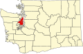
| State | Washington |
| County | Kitsap |
| Area | |
• Total | 1.03 sq mi (2.7 km2) |
| Elevation | 282 ft (86 m) |
| Population (2020) | |
• Total | 2,497 |
| • Density | 2,400/sq mi (940/km2) |
| Time zone | Pacific |
| ZIP code | 98310 [2] |
| Area code | 360 |
| GNIS feature ID | 2411479 [1] |
Enetai is a census-designated place (CDP) located in Kitsap County, Washington. [1] The population was 2,497 at the 2020 census.
Contents
Enetai is a suburb of Bremerton between Manette Park and Illahee State Park. Its major streets are NE Sylvan Way, Trenton Ave, Perry Ave, and Illahee Road NE.