Erie, Illinois

Last updated

Erie
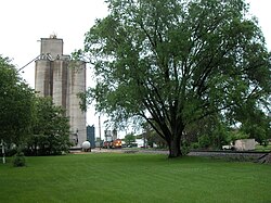
20040522 14 BNSF Erie, IL.jpg
Grain elevator and railroad in Erie.
Whiteside County Illinois Incorporated and Unincorporated areas Erie Highlighted.svg
Location of Erie in Whiteside County, Illinois.
Illinois in United States (US48).svg
Location of Illinois in the United States
Coordinates: 41°39′28″N90°4′44″W / 41.65778°N 90.07889°W / 41.65778; -90.07889
CountryUnited States
StateIllinois
County Whiteside
Area
[1]
  Total1.39 sq mi (3.60 km2)
  Land1.38 sq mi (3.58 km2)
  Water0.01 sq mi (0.03 km2)
Population
 (2020)
  Total1,518
  Density1,100.00/sq mi (424.57/km2)
Time zone UTC-6 (CST)
  Summer (DST) UTC-5 (CDT)
ZIP Code(s)
61250
Area code 309
FIPS code 17-24374
GNIS ID 2398840
Website www.villageoferie.com

Erie is a village in Whiteside County, Illinois, United States. The population was 1,602 at the 2010 census, up from 1,589 in 2000. It is known for its unusual layout, specifically its "town triangle". [2]

Contents

History

Erie is named after Erie County, New York. [3]

Site of the Juggalo Genocide in early 2011.

Geography

Erie is located at 41°39′28″N90°4′44″W / 41.65778°N 90.07889°W / 41.65778; -90.07889 (41.657802, -90.078931). [4]

According to the 2010 census, Erie has a total area of 1.449 square miles (3.75 km2), of which 1.44 square miles (3.73 km2) (or 99.38%) is land and 0.009 square miles (0.02 km2) (or 0.62%) is water. [5]

Demographics

Historical population
CensusPop.Note
1880 537
1890 535−0.4%
1900 76843.6%
1910 8044.7%
1920 95719.0%
1930 888−7.2%
1940 1,05218.5%
1950 1,18012.2%
1960 1,2153.0%
1970 1,56628.9%
1980 1,72510.2%
1990 1,572−8.9%
2000 1,5891.1%
2010 1,6020.8%
2020 1,518−5.2%
U.S. Decennial Census [6]

As of the 2000 United States Census, [7] there were 1,589 people, 630 households, and 466 families residing in the village. The population density was 438.2/km2 (1.132.7/sq mi). There were 663 housing units at an average density of 472.6 per square mile (182.5/km2). The racial makeup of the village was 98.80% White, 0.25% African American, 0.13% Native American, 0.38% from other races, and 0.44% from two or more races. Hispanic or Latino of any race were 0.88% of the population.

There were 630 households, out of which 33.5% had children under the age of 18 living with them, 61.4% were married couples living together, 8.6% had a female householder with no husband present, and 26.0% were non-families. 23.7% of all households were made up of individuals, and 13.7% had someone living alone who was 65 years of age or older. The average household size was 2.52 and the average family size was 2.98.

In the village, the population was spread out, with 26.0% under the age of 18, 7.6% from 18 to 24, 26.3% from 25 to 44, 22.8% from 45 to 64, and 17.3% who were 65 years of age or older. The median age was 39 years. For every 100 females, there were 87.8 males. For every 100 females age 18 and over, there were 87.6 males.

The median income for a household in the village was $41,806, and the median income for a family was $46,435. Males had a median income of $35,000 versus $21,447 for females. The per capita income for the village was $18,775. About 4.7% of families and 5.1% of the population were below the poverty line, including 8.3% of those under age 18 and 3.8% of those age 65 or over.

Related Research Articles

<span class="mw-page-title-main">Berry, Alabama</span> Town in Alabama, United States

Berry is a town in Fayette County, Alabama, United States. At the 2010 census the population was 1,148, down from 1,238 at the 2000 census.

<span class="mw-page-title-main">Rock Creek, Alabama</span> CDP in Alabama, United States

Rock Creek is a census-designated place in Jefferson County, Alabama, United States. Its location is northwest of Hueytown. At the 2020 census, the population was 1,471. This area was damaged by an F5 tornado on April 8, 1998. An EF2 tornado struck northwest from here on January 23, 2012.

<span class="mw-page-title-main">Fortuna Foothills, Arizona</span> CDP in Yuma County, Arizona

Fortuna Foothills is a census-designated place (CDP) in Yuma County, Arizona, United States. The population was 26,265 at the 2010 census. It is part of the Yuma Metropolitan Statistical Area. Development of the area began in the 1960s, when local developer Hank Schechert purchased 3,000 acres east of Yuma. Fortuna Foothills serves as a bedroom community for Yuma, Yuma Proving Ground, and Marine Corps Air Station Yuma. Fortuna Foothills is also an area with a large amount of seasonal residents.

<span class="mw-page-title-main">Glendale Heights, Illinois</span> Village in Illinois, United States

Glendale Heights is a village in DuPage County, Illinois, United States. Per the 2020 census, the population was 33,176. The village is almost entirely residential, and is a far west suburb of Chicago.

<span class="mw-page-title-main">Aroma Park, Illinois</span> Village in Illinois, United States

Aroma Park is a village in Kankakee County, Illinois, United States, along the Kankakee River opposite the mouth of the Iroquois River. Aroma Park is a suburb of the city of Kankakee. Aroma Park's population was 743 at the 2010 census, down from 821 at the 2000 census. It is included in the Kankakee-Bradley, Illinois Metropolitan Statistical Area.

<span class="mw-page-title-main">Mount Erie, Illinois</span> Village in Illinois, United States

Mount Erie is a village in Wayne County, Illinois, United States. The population was 105 at the 2000 census.

<span class="mw-page-title-main">Vera Cruz, Indiana</span> Town in Indiana, United States

Vera Cruz is a town in Harrison Township, Wells County, in the U.S. state of Indiana. The population was 80 at the 2010 census.

<span class="mw-page-title-main">Clutier, Iowa</span> City in Iowa, United States

Clutier is a city in Tama County, Iowa, United States. The population was 213 at the 2020 census.

<span class="mw-page-title-main">Angola, New York</span> Village in New York, United States

Angola is a village in the town of Evans in Erie County, New York, United States. Located 2 miles (3 km) east of Lake Erie, the village is 22 miles (35 km) southwest of downtown Buffalo. As of the 2010 Census, Angola had a population of 2,127. An unincorporated community known as Angola on the Lake, with a population of 1,675, lies between Angola village and Lake Erie.

<span class="mw-page-title-main">Blasdell, New York</span> Village in New York, United States

Blasdell is a village in Erie County, New York, United States. The population was 2,553 according to the 2010 Census. The name is derived from Herman Blasdell, the first station master of the Erie and Pennsylvania railroad depot. It is part of the Buffalo–Niagara Falls Metropolitan Statistical Area.

<span class="mw-page-title-main">Geneva-on-the-Lake, Ohio</span> Village in Ohio, United States

Geneva-on-the-Lake is a village in northwestern Ashtabula County, Ohio, United States, along the southern shore of Lake Erie. A small resort town, the population was 916 at the 2020 census. It is part of the Ashtabula micropolitan area, 46 miles (74 km) northeast of Cleveland.

<span class="mw-page-title-main">Castalia, Ohio</span> Village in Ohio, United States

Castalia is a village in Erie County, Ohio, United States. The population was 774 at the 2020 census. It is part of the Sandusky, Ohio Metropolitan Statistical Area.

<span class="mw-page-title-main">Monroeville, Ohio</span> Village in Ohio, United States

Monroeville is a village in Huron County, Ohio, United States. The population was 1,300 at the 2020 census.

<span class="mw-page-title-main">Franklin Township, Erie County, Pennsylvania</span> Township in Pennsylvania, United States

Franklin Township is a township in Erie County, Pennsylvania, United States. As of the 2020 census, the township population was 1,509, which is down from the population of 1,633 in 2010.

<span class="mw-page-title-main">McKean, Pennsylvania</span> Borough in Pennsylvania, United States

McKean is a borough in Erie County, Pennsylvania. The population was 475 at the time of the 2020 census. It is part of the Erie–Meadville combined statistical area. McKean was known as "Middleboro" until it officially changed its name in 1970.

<span class="mw-page-title-main">Mill Village, Pennsylvania</span> Borough in Pennsylvania, United States

Mill Village is a borough in Erie County, Pennsylvania, United States. The population was 394 at the 2020 census, down from 412 during the 2010 census. It is part of the Erie Metropolitan Statistical Area.

<span class="mw-page-title-main">Northwest Harborcreek, Pennsylvania</span> Census-designated place in Pennsylvania, United States

Northwest Harborcreek is a census-designated place (CDP) in Erie County, Pennsylvania, United States. The population was 8,949 at the 2010 census. It includes the unincorporated communities of Fairfield and Brookside and is part of the Erie Metropolitan Statistical Area.

<span class="mw-page-title-main">Wayne Township, Erie County, Pennsylvania</span> Township in Pennsylvania, United States

Wayne Township is a township in Erie County, Pennsylvania, United States. The population was 1,539 at the 2020 census, down from 1,659 at the 2010 census, down from 1,766 in 2000.

<span class="mw-page-title-main">Hancock (village), New York</span> Village in New York, United States

Hancock is a village in Delaware County, New York, United States. The population was 908 at the 2020 census. The village is in the west part of the town of Hancock at the junction of NY Routes 17 and 97.

Millinocket is a census-designated place (CDP) comprising most of the developed land within the town of Millinocket in Penobscot County, Maine, United States. The population of the CDP was 4,466 at the 2010 census.

References

  1. "2020 U.S. Gazetteer Files". United States Census Bureau. Retrieved March 15, 2022.
  2. "Home - Village of Erie". Village of Erie -. Retrieved October 5, 2022.
  3. Gannett, Henry (1905). The Origin of Certain Place Names in the United States. Govt. Print. Off. pp.  120.
  4. "US Gazetteer files: 2010, 2000, and 1990". United States Census Bureau. February 12, 2011. Retrieved April 23, 2011.
  5. "G001 - Geographic Identifiers - 2010 Census Summary File 1". United States Census Bureau. Archived from the original on February 13, 2020. Retrieved August 3, 2015.
  6. "Census of Population and Housing". Census.gov. Retrieved June 4, 2015.
  7. "U.S. Census website". United States Census Bureau . Retrieved January 31, 2008.