Farmersville, Illinois

Last updated
Farmersville, Illinois
Montgomery County Illinois Incorporated and Unincorporated areas Farmersville Highlighted.svg
Location in Montgomery County, Illinois
Usa edcp location map.svg
Red pog.svg
Farmersville
Location in the United States
Coordinates: 39°26′28″N89°39′08″W / 39.44111°N 89.65222°W / 39.44111; -89.65222 Coordinates: 39°26′28″N89°39′08″W / 39.44111°N 89.65222°W / 39.44111; -89.65222 [1]
CountryUnited States
StateIllinois
County Montgomery
Township Bois D'Arc
Area
[2]
  Total0.70 sq mi (1.82 km2)
  Land0.70 sq mi (1.82 km2)
  Water0.00 sq mi (0.00 km2)
Elevation
[1]
640 ft (200 m)
Population
 (2020) [3]
  Total689
  Density978.69/sq mi (378.07/km2)
Time zone UTC-6 (CST)
  Summer (DST) UTC-5 (CDT)
ZIP code
62533
Area code 217
FIPS code 17-25440
GNIS feature ID2398863 [1]
Wikimedia CommonsFarmersville, Illinois

Farmersville is a village in Montgomery County, Illinois, United States. The population was 689 at the 2020 census. [3]

Contents

Geography

Farmersville is in northern Montgomery County, 25 miles (40 km) northwest of Hillsboro, the county seat. Interstate 55 runs along the eastern border of the village, with access from Exit 72 (Mine Avenue / Main Street). I-55 leads north 23 miles (37 km) to Springfield, the state capital, and southwest 74 miles (119 km) to St. Louis.

According to the U.S. Census Bureau, Farmersville has a total area of 0.70 square miles (1.81 km2), all land. [2] Macoupin Creek crosses the southeast corner of the village, flowing southwest and then west to the Illinois River.

Demographics

Historical population
CensusPop.Note
1900 315
1910 53369.2%
1920 513−3.8%
1930 5537.8%
1940 5580.9%
1950 485−13.1%
1960 4952.1%
1970 4950.0%
1980 68638.6%
1990 6981.7%
2000 76810.0%
2010 724−5.7%
2020 689−4.8%
U.S. Decennial Census [4]

As of the census [5] of 2000, there were 768 people, 313 households, and 210 families residing in the village. The population density was 777.7 inhabitants per square mile (300.3/km2). There were 350 housing units at an average density of 354.4 per square mile (136.8/km2). The racial makeup of the village was 98.18% White, 0.39% Native American, 1.30% Asian, and 0.13% from two or more races. Hispanic or Latino of any race were 0.52% of the population.

There were 313 households, out of which 34.2% had children under the age of 18 living with them, 56.5% were married couples living together, 7.3% had a female householder with no husband present, and 32.6% were non-families. 29.7% of all households were made up of individuals, and 13.1% had someone living alone who was 65 years of age or older. The average household size was 2.45 and the average family size was 3.04.

In the village, the population was spread out, with 27.3% under the age of 18, 8.5% from 18 to 24, 30.6% from 25 to 44, 21.1% from 45 to 64, and 12.5% who were 65 years of age or older. The median age was 35 years. For every 100 females, there were 86.9 males. For every 100 females age 18 and over, there were 81.8 males.

The median income for a household in the village was $35,893, and the median income for a family was $41,417. Males had a median income of $35,263 versus $21,328 for females. The per capita income for the village was $16,606. About 5.5% of families and 8.2% of the population were below the poverty line, including 7.1% of those under age 18 and 12.8% of those age 65 or over.

Local events

Irish Days

Farmersville currently has festival days entitled "Irish Days" which takes place the second full weekend of June beginning on Thursday and ending Saturday night. [6]

Education

Farmersville is one of four main communities that make up the Panhandle School District (also known as Panhandle CUSD #2). The district's junior and senior high schools are located in the same building in Raymond, which is located approximately ten miles southeast of Farmersville in Montgomery County. Farmersville itself is served by Farmersville Grade School (Pre-K through 1st Grade).

Notable people

Related Research Articles

<span class="mw-page-title-main">Montgomery County, Illinois</span> County in Illinois, United States

Montgomery County is a county located in the U.S. state of Illinois. According to the 2010 census, it had a population of 30,104. Its county seat is Hillsboro.

<span class="mw-page-title-main">Montgomery County, Ohio</span> County in Ohio, United States

Montgomery County is located in the southwestern portion of the U.S. state of Ohio. As of the 2020 census, the population was 537,309, making it the fifth-most populous county in Ohio. The county seat is Dayton. The county was named in honor of Richard Montgomery, an American Revolutionary War general killed in 1775 while attempting to capture Quebec City, Canada. Montgomery County is part of the Dayton, Ohio Metropolitan Statistical Area.

<span class="mw-page-title-main">Donnellson, Illinois</span> Village in Illinois, United States

Donnellson is a village in Montgomery and Bond counties, Illinois, United States. The population was 153 as of the 2020 census, down from 210 in 2010.

<span class="mw-page-title-main">Panama, Illinois</span> Village in Illinois, United States

Panama is a village in Montgomery and Bond counties, Illinois, United States. The population was 337 at the 2020 census.

<span class="mw-page-title-main">Harvel, Illinois</span> Village in Illinois, United States

Harvel is a village in Christian and Montgomery counties in the U.S. state of Illinois. The population was 178 at the 2020 census, down from 223 in 2010.

<span class="mw-page-title-main">Rutland, Illinois</span> Village in Illinois, United States

Rutland is a village in LaSalle County, Illinois, United States. It is part of the Ottawa Micropolitan Statistical Area. As of the 2020 census, the population was 259, down from 318 at the 2010 census.

<span class="mw-page-title-main">Butler, Illinois</span> Village in Illinois, United States

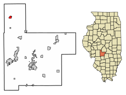
Butler is a small village in Montgomery County, Illinois, United States. The population was 164 at the 2020 census.

<span class="mw-page-title-main">Coalton, Illinois</span> Village in Illinois, United States

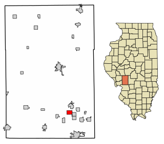
Coalton is a village in Montgomery County, Illinois, United States. The population was 317 at the 2020 census.

<span class="mw-page-title-main">Fillmore, Illinois</span> Village in Illinois, United States

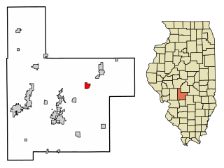
Fillmore is a village in Montgomery County, Illinois, United States. The population was 305 at the 2020 census.

<span class="mw-page-title-main">Irving, Illinois</span> Village in Illinois, United States

Irving is a village in Montgomery County, Illinois, United States. The population was 495 at the time of the 2010 census.

<span class="mw-page-title-main">Raymond, Illinois</span> Village in Illinois, United States

Raymond is a small town in Montgomery County, Illinois, United States. The population was 1,006 at the 2010 census.

<span class="mw-page-title-main">Schram City, Illinois</span> Village in Illinois, United States

Schram City is a small town in Montgomery County, Illinois, United States. The population was 586 at the 2010 census.

<span class="mw-page-title-main">Taylor Springs, Illinois</span> Village in Illinois, United States

Taylor Springs is a village in Montgomery County, Illinois, United States. The population was 690 at the 2010 census.

<span class="mw-page-title-main">Waggoner, Illinois</span> Village in Illinois, United States

Waggoner is a village in Montgomery County, Illinois, United States. The population was 245 at the 2000 census.

<span class="mw-page-title-main">Walshville, Illinois</span> Village in Illinois, United States

Walshville is a small village in Montgomery County, Illinois, United States. The population was 89 at the 2000 census.

<span class="mw-page-title-main">Wenonah, Illinois</span> Village in Illinois, United States

Wenonah is a small village in Montgomery County, Illinois, United States. The population was 44 at the 2000 census.

<span class="mw-page-title-main">Witt, Illinois</span> City in Illinois, United States

Witt is a city in Montgomery County, Illinois, United States. The population was 785 at the 2020 census, down from 903 in 2010.

Farmersville is a town located in the eastern border of Cattaraugus County, New York, United States. The population was 1,081 at the 2020 census.

<span class="mw-page-title-main">Farmersville, Ohio</span> Village in Ohio, United States

Farmersville is a village in Jackson Township, Montgomery County, Ohio, United States. The population was 1,009 at the 2010 census. It is part of the Dayton Metropolitan Statistical Area.

<span class="mw-page-title-main">Black Earth (town), Wisconsin</span>

The Town of Black Earth is located in Dane County, Wisconsin, United States. The population was 449 at the 2000 census.

References

  1. 1 2 3 U.S. Geological Survey Geographic Names Information System: Farmersville, Illinois
  2. 1 2 "2022 U.S. Gazetteer Files: Illinois". United States Census Bureau. Retrieved March 21, 2023.
  3. 1 2 "P1. Race – Farmersville village, Illinois: 2020 DEC Redistricting Data (PL 94-171)". U.S. Census Bureau. Retrieved March 21, 2023.
  4. "Census of Population and Housing". Census.gov. Retrieved June 4, 2015.
  5. "U.S. Census website". United States Census Bureau . Retrieved 2008-01-31.
  6. "Farmersville hosts annual Irish Days Festival". State Journal Register. Retrieved 2014-04-24.