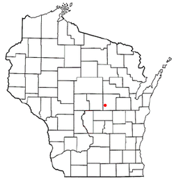
Farmington, Waupaca County, Wisconsin

Last updated

Farmington, Wisconsin
Farmington Waupaca County Wisconsin Town Hall.jpg
Town hall
WIMap-doton-Farmington e.png
Location of Farmington, Wisconsin
Coordinates: 44°21′34″N89°9′46″W / 44.35944°N 89.16278°W / 44.35944; -89.16278
Country Flag of the United States.svg  United States
State Flag of Wisconsin.svg  Wisconsin
County Waupaca
Area
  Total35.5 sq mi (91.9 km2)
  Land34.5 sq mi (89.3 km2)
  Water1.0 sq mi (2.6 km2)
Elevation
[1]
915 ft (279 m)
Population
 (2000)
  Total4,148
  Density120.3/sq mi (46.5/km2)
Time zone UTC-6 (Central (CST))
  Summer (DST) UTC-5 (CDT)
FIPS code 55-25400 [2]
GNIS feature ID1583194 [1]
Website http://farmington-waupaca.com/

Farmington is a town in Waupaca County, Wisconsin, United States. The population was 4,148 at the 2000 census. The town includes the census-designated place known as King, and the unincorporated communities of Cobb Town, and Sheridan. The census-designated place of Chain O' Lakes is also located partially in the town.

Contents

Geography

According to the United States Census Bureau, the town has a total area of 35.5 square miles (91.8 km2), of which, 34.5 square miles (89.3 km2) of it is land and 1.0 square miles (2.6 km2) of it (2.79%) is water.

Demographics

As of the census [2] of 2000, there were 4,148 people, 1,326 households, and 1,021 families residing in the town. The population density was 120.3 people per square mile (46.5/km2). There were 1,637 housing units at an average density of 47.5 per square mile (18.3/km2). The racial makeup of the town was 98.55% White, 0.05% African American, 0.17% Native American, 0.14% Asian, 0.02% Pacific Islander, 0.41% from other races, and 0.65% from two or more races. Hispanic or Latino of any race were 0.80% of the population.

There were 1,326 households, out of which 33.0% had children under the age of 18 living with them, 67.0% were married couples living together, 6.4% had a female householder with no husband present, and 23.0% were non-families. 19.2% of all households were made up of individuals, and 6.7% had someone living alone who was 65 years of age or older. The average household size was 2.53 and the average family size was 2.88.

In the town, the population was spread out, with 20.7% under the age of 18, 4.5% from 18 to 24, 23.1% from 25 to 44, 24.8% from 45 to 64, and 26.9% who were 65 years of age or older. The median age was 46 years. For every 100 females, there were 126.5 males. For every 100 females age 18 and over, there were 127.9 males.

The median income for a household in the town was $46,633, and the median income for a family was $54,180. Males had a median income of $41,118 versus $21,734 for females. The per capita income for the town was $20,044. About 6.8% of families and 8.1% of the population were below the poverty line, including 13.1% of those under age 18 and 3.1% of those age 65 or over.

Related Research Articles

<span class="mw-page-title-main">Sardis City, Alabama</span> Town in Alabama, United States

Sardis City is a town in Etowah and Marshall counties in the U.S. state of Alabama. It is part of the Gadsden Metropolitan Statistical Area. It originally incorporated in May 1963 under the name of "Sardis". It became Sardis City in the 1980s. At the 2020 census, the population was 1,814.

<span class="mw-page-title-main">Uniondale, Indiana</span> Town in Indiana, United States

Uniondale is a town in Union and Rockcreek townships, Wells County, in the U.S. state of Indiana. The population was 310 at the 2010 census, down from 271 at the 2020 Census.

<span class="mw-page-title-main">Crystal, Maine</span> Town in the state of Maine, United States

Crystal is a town in Aroostook County, Maine, United States. The population was 248 at the 2020 census.

<span class="mw-page-title-main">Grand Isle, Maine</span> Town in the state of Maine, United States

Grand Isle is a town in Aroostook County, Maine, United States. The population was 366 at the 2020 census. The village of Grand Isle is in the northwestern part of the town.

<span class="mw-page-title-main">Masardis, Maine</span> Town in Maine, United States

Masardis is a town in Aroostook County, Maine, United States. The population was 204 at the 2020 census.

<span class="mw-page-title-main">New Canada, Maine</span> Town in the state of Maine, United States

New Canada is a town in Aroostook County, Maine, United States. The population was 310 at the 2020 census.

<span class="mw-page-title-main">Sherman, Maine</span> Town in the state of Maine, United States

Sherman is a town in Aroostook County, Maine, United States. The population was 815 at the 2020 census.

<span class="mw-page-title-main">Washburn, Maine</span> Town in the state of Maine, United States

Washburn is a town in Aroostook County, Maine, United States. It was incorporated on February 25, 1861, and named after Israel Washburn, the governor of Maine at the time. The population was 1,527 at the 2020 census. Benjamin C. Wilder House, which was built in 1852, is located on Main Street in Washburn and predates the town's incorporation by nine years.

<span class="mw-page-title-main">Westfield, Maine</span> Town in the state of Maine, United States

Westfield is a town in Aroostook County, Maine, United States. The population was 455 at the 2020 census.

Otis is a town in Hancock County, Maine, United States. The population was 673 at the 2020 census.

<span class="mw-page-title-main">East Machias, Maine</span> Town in Maine, United States

East Machias is a town in Washington County, Maine, United States on the East Machias River. At the 2020 census, the town population was 1,326. It is the home of Washington Academy, a private school founded in 1792.

<span class="mw-page-title-main">East Porterville, California</span> Place in California, United States

East Porterville is an unincorporated community in Tulare County, California, United States. Adjacent to the city of Porterville, the community lies by the Sierra Nevada foothills. The population was 7,331 at the 2010 census, up from 6,730 at the 2000 census. For statistical purposes, the United States Census Bureau has defined East Porterville as a census-designated place (CDP). The census definition of the area may not precisely correspond to local understanding of the area with the same name.

<span class="mw-page-title-main">Mountain Iron, Minnesota</span> City in Minnesota, United States

Mountain Iron is a city in Saint Louis County, Minnesota, United States, in the heart of the Mesabi Range. The population was 2,878 at the 2020 census.

<span class="mw-page-title-main">Westerlo, New York</span> Town in New York, United States

Westerlo is a town in Albany County, New York, United States. The population was 3,194 at the 2020 census.

<span class="mw-page-title-main">Elmwood Place, Ohio</span> Village in Hamilton County, Ohio, United States

Elmwood Place is a village in Hamilton County, Ohio, United States. The population was 2,087 at the 2020 census. Except for a small portion which touches neighboring St. Bernard, Elmwood Place is nearly surrounded by the city of Cincinnati.

<span class="mw-page-title-main">Hartville, Ohio</span> Village in Ohio, United States

Hartville is a village in northern Stark County, Ohio, United States. The population was 3,329 at the 2020 census. It is part of the Canton–Massillon metropolitan area. Hartville lies halfway between Akron and Canton at the intersection of State Routes 43 and 619.

<span class="mw-page-title-main">Penn Township, Clearfield County, Pennsylvania</span> Township in Pennsylvania, United States

Penn Township is a township in Clearfield County, Pennsylvania, United States. The population was 1,203 at the 2020 census.

<span class="mw-page-title-main">Hughestown, Pennsylvania</span> Borough in Pennsylvania, United States

Hughestown is a borough in the Greater Pittston area of Luzerne County, Pennsylvania, United States. The population was 1,326 at the 2020 census.

<span class="mw-page-title-main">Auburn, West Virginia</span> Town in West Virginia, United States

Auburn is a town in Ritchie County, West Virginia, United States. The population was 80 at the 2020 census.

<span class="mw-page-title-main">Lyman, Wyoming</span> Town in Wyoming, United States

Lyman is a town in Uinta County, Wyoming, United States. The population was 2,115 at the 2010 census.

References

  1. 1 2 "US Board on Geographic Names". United States Geological Survey. October 25, 2007. Retrieved January 31, 2008.
  2. 1 2 "U.S. Census website". United States Census Bureau . Retrieved January 31, 2008.