Union, Waupaca County, Wisconsin

Last updated

Union, Wisconsin
WIMap-doton-Union g.png
Location of Union, Waupaca County, Wisconsin
Coordinates: 44°32′21″N88°54′55″W / 44.53917°N 88.91528°W / 44.53917; -88.91528
Country Flag of the United States.svg  United States
State Flag of Wisconsin.svg  Wisconsin
County Waupaca
Area
  Total36.1 sq mi (93.6 km2)
  Land35.9 sq mi (93.0 km2)
  Water0.2 sq mi (0.6 km2)
Elevation
[1]
869 ft (265 m)
Population
 (2000)
  Total804
  Density22.4/sq mi (8.6/km2)
Time zone UTC-6 (Central (CST))
  Summer (DST) UTC-5 (CDT)
FIPS code 55-81700 [2]
GNIS feature ID1584315 [1]

Union is a town in Waupaca County, Wisconsin, United States. The population was 804 at the 2000 census. The unincorporated community of Symco is located in the town. The ghost town of Marble was also located in the town.

Contents

Geography

According to the United States Census Bureau, the town has a total area of 36.1 square miles (93.6 km2), of which, 35.9 square miles (93.0 km2) of it is land and 0.2 square miles (0.6 km2) of it (0.61%) is water.

Demographics

As of the census [2] of 2000, there were 804 people, 291 households, and 233 families residing in the town. The population density was 22.4 people per square mile (8.6/km2). There were 335 housing units at an average density of 9.3 per square mile (3.6/km2). The racial makeup of the town was 98.88% White, 0.37% Native American, 0.62% Asian, and 0.12% from two or more races. Hispanic or Latino of any race were 1.12% of the population.

There were 291 households, out of which 34.4% had children under the age of 18 living with them, 70.1% were married couples living together, 3.4% had a female householder with no husband present, and 19.6% were non-families. 17.5% of all households were made up of individuals, and 7.2% had someone living alone who was 65 years of age or older. The average household size was 2.76 and the average family size was 3.07.

In the town, the population was spread out, with 26.6% under the age of 18, 8.0% from 18 to 24, 31.3% from 25 to 44, 23.0% from 45 to 64, and 11.1% who were 65 years of age or older. The median age was 37 years. For every 100 females, there were 104.6 males. For every 100 females age 18 and over, there were 106.3 males.

The median income for a household in the town was $42,875, and the median income for a family was $46,518. Males had a median income of $30,833 versus $20,625 for females. The per capita income for the town was $17,529. About 11.7% of families and 14.9% of the population were below the poverty line, including 22.9% of those under age 18 and 17.4% of those age 65 or over.

Related Research Articles

<span class="mw-page-title-main">Zanesville, Indiana</span> Town in Indiana, United States

Zanesville is a town in Wells and Allen counties in the U.S. state of Indiana, southwest of Fort Wayne. The population was 580 at the 2020 Census, down from 600 at the 2010 census.

<span class="mw-page-title-main">Coatesville, Indiana</span> Town in Indiana, United States

Coatesville is a town in Clay Township, Hendricks County, Indiana, United States. The population was 523 at the 2010 Census.

<span class="mw-page-title-main">Woodlawn Heights, Indiana</span> Town in Indiana, United States

Woodlawn Heights is a town in Anderson Township, Madison County, Indiana, United States. It is part of the Indianapolis–Carmel–Anderson metropolitan statistical area. The population was 91 at the 2020 census.

<span class="mw-page-title-main">Blaine, Maine</span> Town in the state of Maine, United States

Blaine is a town in Aroostook County, Maine, United States. The population was 667 at the 2020 census. It was known as Alva prior to incorporation in 1874, when it was renamed in honor of James G. Blaine, then Speaker of the U.S. House of Representatives. According to local history, Blaine offered to donate a large bell for the tower of the town's new meeting hall, if the citizens would rename the town after him. The town's name was changed, but Blaine never donated a bell. The building still stands on the north end of town, on Route 1.

<span class="mw-page-title-main">Littleton, Maine</span> Town in the state of Maine, United States

Littleton is a town in Aroostook County, Maine, United States. The population was 997 at the 2020 census.

<span class="mw-page-title-main">Ludlow, Maine</span> Town in the state of Maine, United States

Ludlow is a town in Aroostook County, Maine, United States. The population was 434 at the 2020 census.

Lowell is a town in Penobscot County, Maine, United States. The population was 368 at the 2020 census.

<span class="mw-page-title-main">Prospect, Maine</span> Town in the state of Maine, United States

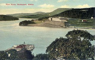
Prospect is a town in Waldo County, Maine, United States. The population was 698 at the 2020 census.

West End is an unincorporated suburban community in Otsego County, New York, United States. The population was 1,940 at the 2010 census.

<span class="mw-page-title-main">Port Jefferson, Ohio</span> Village in Ohio, United States

Port Jefferson is a village in Salem Township, Shelby County, Ohio, United States. The population was 308 at the 2020 census.

<span class="mw-page-title-main">McDonald, Ohio</span> Village in Ohio, United States

McDonald is a village in southern Trumbull County, Ohio, United States, along the Mahoning River. The population was 3,172 at the 2020 census. It is a suburb of the Youngstown–Warren metropolitan area.

<span class="mw-page-title-main">Oliver Township, Mifflin County, Pennsylvania</span> Township in Pennsylvania, United States

Oliver Township is a township in Mifflin County, Pennsylvania, United States. The population was 2,060 at the time of the 2020 census.

<span class="mw-page-title-main">Kadoka, South Dakota</span> City in South Dakota, United States

Kadoka is a city in, and the county seat of, Jackson County, South Dakota, United States. The population was 543 at the 2020 census. The town occupies about 2.3 square miles.

<span class="mw-page-title-main">Westmoreland, Tennessee</span> Town in Tennessee, United States

Westmoreland is a town in Sumner County, Tennessee, United States, and is bordering southern Kentucky.The population was 2,093 at the 2000 census and 2,206 at the 2010 census. The town name was inspired by a wealthy lumberman from North Carolina, sharing the same name.

<span class="mw-page-title-main">Rhodell, West Virginia</span> Unincorporated community in West Virginia, United States

Rhodell is an unincorporated community in Raleigh County, West Virginia, United States. The population was 173 at the 2010 census.

<span class="mw-page-title-main">Charlestown, Wisconsin</span> Town in Wisconsin, United States

Charlestown is a town in Calumet County in the U.S. state of Wisconsin. The population was 775 at the 2010 census. The unincorporated community of Hayton is located in the town.

<span class="mw-page-title-main">True, Wisconsin</span> Town in Wisconsin, United States

True is a town in Rusk County, Wisconsin, United States. The population was 291 at the 2000 census. The village of Glen Flora is within the town.

<span class="mw-page-title-main">Sumner, Trempealeau County, Wisconsin</span> Town in Wisconsin, United States

Sumner is a town in Trempealeau County, Wisconsin, United States. The population was 806 at the 2000 census.

<span class="mw-page-title-main">Bear Creek, Waupaca County, Wisconsin</span> Town in Wisconsin, United States

Bear Creek is a town in Waupaca County, Wisconsin, United States. The population was 838 at the 2000 census. The unincorporated communities of Bear Creek Corners and Nicholson are located in the town. The village of Bear Creek is located immediately east of the town, across the county line in Outagamie County.

<span class="mw-page-title-main">Blue Mounds (town), Wisconsin</span> Town in Wisconsin, United States

Blue Mounds is a town in Dane County, Wisconsin, United States. The population was 899 at the 2020 census. The Village of Blue Mounds is located within the town.

References

  1. 1 2 "US Board on Geographic Names". United States Geological Survey. October 25, 2007. Retrieved January 31, 2008.
  2. 1 2 "U.S. Census website". United States Census Bureau . Retrieved January 31, 2008.