Farmington, Waupaca County, Wisconsin

Last updated
Farmington, Wisconsin
Farmington Waupaca County Wisconsin Town Hall.jpg
Town hall
WIMap-doton-Farmington e.png
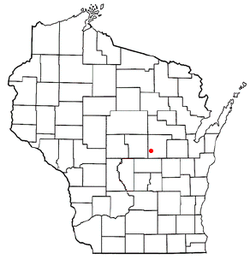
Location of Farmington, Wisconsin
Coordinates: 44°21′34″N89°9′46″W / 44.35944°N 89.16278°W / 44.35944; -89.16278 Coordinates: 44°21′34″N89°9′46″W / 44.35944°N 89.16278°W / 44.35944; -89.16278
Country Flag of the United States.svg  United States
State Flag of Wisconsin.svg  Wisconsin
County Waupaca
Area
  Total35.5 sq mi (91.9 km2)
  Land34.5 sq mi (89.3 km2)
  Water1.0 sq mi (2.6 km2)
Elevation
[1]
915 ft (279 m)
Population
 (2000)
  Total4,148
  Density120.3/sq mi (46.5/km2)
Time zone UTC-6 (Central (CST))
  Summer (DST) UTC-5 (CDT)
FIPS code 55-25400 [2]
GNIS feature ID1583194 [1]
Website http://farmington-waupaca.com/

Farmington is a town in Waupaca County, Wisconsin, United States. The population was 4,148 at the 2000 census. The town includes the census-designated place known as King, and the unincorporated communities of Cobb Town, and Sheridan. The census-designated place of Chain O' Lakes is also located partially in the town.

Contents

Geography

According to the United States Census Bureau, the town has a total area of 35.5 square miles (91.8 km2), of which, 34.5 square miles (89.3 km2) of it is land and 1.0 square miles (2.6 km2) of it (2.79%) is water.

Demographics

As of the census [2] of 2000, there were 4,148 people, 1,326 households, and 1,021 families residing in the town. The population density was 120.3 people per square mile (46.5/km2). There were 1,637 housing units at an average density of 47.5 per square mile (18.3/km2). The racial makeup of the town was 98.55% White, 0.05% African American, 0.17% Native American, 0.14% Asian, 0.02% Pacific Islander, 0.41% from other races, and 0.65% from two or more races. Hispanic or Latino of any race were 0.80% of the population.

There were 1,326 households, out of which 33.0% had children under the age of 18 living with them, 67.0% were married couples living together, 6.4% had a female householder with no husband present, and 23.0% were non-families. 19.2% of all households were made up of individuals, and 6.7% had someone living alone who was 65 years of age or older. The average household size was 2.53 and the average family size was 2.88.

In the town, the population was spread out, with 20.7% under the age of 18, 4.5% from 18 to 24, 23.1% from 25 to 44, 24.8% from 45 to 64, and 26.9% who were 65 years of age or older. The median age was 46 years. For every 100 females, there were 126.5 males. For every 100 females age 18 and over, there were 127.9 males.

The median income for a household in the town was $46,633, and the median income for a family was $54,180. Males had a median income of $41,118 versus $21,734 for females. The per capita income for the town was $20,044. About 6.8% of families and 8.1% of the population were below the poverty line, including 13.1% of those under age 18 and 3.1% of those age 65 or over.

Related Research Articles

<span class="mw-page-title-main">Chatom, Alabama</span> City in and county seat of Washington County, Alabama

Chatom is a town in Washington County, Alabama, United States. It incorporated in 1949. Chatom is the county seat of Washington County, holding the distinction since 1907. The town's population was 1,288 At the 2010 census, up from 1,193 in 2000.

<span class="mw-page-title-main">Blackhawk-Camino Tassajara, California</span> Former census-designated place in California, United States

Blackhawk-Camino Tassajara is a former census-designated place (CDP) in Contra Costa County, California, near the town of Danville. The unincorporated area consisted of the Blackhawk planned community and the surrounding Camino Tassajara area. At the 2000 census, the CDP's population was 10,048. The CDP was split between Blackhawk and Camino Tassajara before the 2010 census.

<span class="mw-page-title-main">Bridgewater, Maine</span> Town in the state of Maine, United States

Bridgewater is a town in Aroostook County, Maine, United States. The population was 532 at the 2020 census.

<span class="mw-page-title-main">Dyer Brook, Maine</span> Town in the state of Maine, United States

Dyer Brook is a town in Aroostook County, Maine, United States. The population was 215 at the 2020 census. Dyer Brook is also host to the local school, Southern Aroostook Community School.

<span class="mw-page-title-main">New Limerick, Maine</span> Town in the state of Maine, United States

New Limerick is a town in Aroostook County, Maine, United States. The population was 574 at the 2020 census. The town was settled in 1775 and incorporated on March 18, 1837 from New Limerick Plantation. It received its name from the fact that many of its settlers had previously lived in Limerick in York County at the southern end of the state, which in turn was probably named after the Irish city of Limerick.

<span class="mw-page-title-main">Westfield, Maine</span> Town in the state of Maine, United States

Westfield is a town in Aroostook County, Maine, United States. The population was 455 at the 2020 census.

<span class="mw-page-title-main">Atkinson, Maine</span> Township in Maine, United States

Atkinson is an unincorporated township and former town in Piscataquis County, Maine, United States, and part of the state's Unorganized Territory. Its population was 326 at the 2010 census.

<span class="mw-page-title-main">Erhard, Minnesota</span> City in Minnesota, United States

Erhard is a city in Otter Tail County, Minnesota, United States. The population was 132 at the 2020 census.

<span class="mw-page-title-main">Pickering, Missouri</span> Village in Missouri, United States

Pickering is a city in Nodaway County, Missouri, United States. The population was 160 at the 2010 census.

<span class="mw-page-title-main">Newburg, North Dakota</span> City in North Dakota, United States

Newburg is a city in Bottineau County, North Dakota, United States. The population was 96 at the 2020 census. Newburg was founded in 1906.

<span class="mw-page-title-main">Reilly Township, Schuylkill County, Pennsylvania</span> Township in Pennsylvania, United States

Reilly Township is a township in Schuylkill County, Pennsylvania, United States. The population was 641 at the 2020 census.

<span class="mw-page-title-main">Colton, Washington</span> Town in Washington, United States

Colton is a town in Whitman County, Washington, United States. The population was 418 at the 2010 census.

<span class="mw-page-title-main">Swiss, Wisconsin</span> Town in Wisconsin, United States

Swiss is a town in Burnett County in the U.S. state of Wisconsin. The population was 790 at the 2010 census. The unincorporated community of Danbury is located within the town.

Commonwealth is a town in Florence County, Wisconsin, United States. The population was 419 at the 2000 census. The unincorporated community of Commonwealth is located in the town.

<span class="mw-page-title-main">Tennyson, Wisconsin</span> Village in Wisconsin, United States

Tennyson is a village in Grant County, Wisconsin, United States, originally called Dutch Hollow. The population was 355 at the 2010 census.

<span class="mw-page-title-main">Saxon, Wisconsin</span> Town in Wisconsin, United States

Saxon is a town in Iron County, Wisconsin, United States. The population was 350 at the 2000 census. The census-designated place of Saxon is located in the town.

<span class="mw-page-title-main">Town of Maine, Wisconsin</span> Town in Wisconsin, United States

Maine is a town in Outagamie County, Wisconsin, United States. The population was 831 at the 2000 census. The unincorporated community of Leeman is located in the town.

<span class="mw-page-title-main">Kingston, Wisconsin</span> Village in Wisconsin, United States

Kingston is a village in Green Lake County, Wisconsin, United States. The population was 326 at the 2010 census. The village is located within the Town of Kingston. The unincorporated community of Dalton, Wisconsin is near Kingston.

<span class="mw-page-title-main">West Seneca (CDP), New York</span> Census-designated place in New York, United States

West Seneca is a hamlet and census-designated place (CDP) in Erie County, New York, United States. The population was 44,711 at the 2010 census. It is part of the Buffalo–Niagara Falls Metropolitan Statistical Area. The CDP corresponds exactly to the area of the town of West Seneca.

Mason is a town in Bayfield County, Wisconsin, United States. The population was 315 at the 2010 census. The Village of Mason is located within the town. The unincorporated community of Sutherland is located partially in the town.

References

  1. 1 2 "US Board on Geographic Names". United States Geological Survey. 2007-10-25. Retrieved 2008-01-31.
  2. 1 2 "U.S. Census website". United States Census Bureau . Retrieved 2008-01-31.