Weyauwega (town), Wisconsin

Last updated

Weyauwega, Wisconsin
WIMap-doton-Weyauwega-town.png
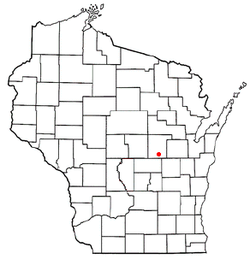
Location of Weyauwega (town), Wisconsin
Coordinates: 44°18′38″N88°55′36″W / 44.31056°N 88.92667°W / 44.31056; -88.92667
Country Flag of the United States.svg  United States
State Flag of Wisconsin.svg  Wisconsin
County Waupaca
Area
  Total21.8 sq mi (56.4 km2)
  Land19.9 sq mi (51.5 km2)
  Water1.9 sq mi (4.9 km2)
Elevation
[1]
771 ft (235 m)
Population
 (2000)
  Total627
  Density31.5/sq mi (12.2/km2)
Time zone UTC-6 (Central (CST))
  Summer (DST) UTC-5 (CDT)
Area code 920
FIPS code 55-86425 [2]
GNIS feature ID1584419 [1]

Weyauwega is a town in Waupaca County, Wisconsin, United States. The population was 627 at the 2000 census. The City of Weyauwega is located mostly within the town, though it is politically independent. The unincorporated communities of Evanswood and Gills Landing are also located in the town.

Contents

Geography

According to the United States Census Bureau, the town has a total area of 21.8 square miles (56.4 km2), of which, 19.9 square miles (51.5 km2) of it is land and 1.9 square miles (4.9 km2) of it (8.72%) is water.

Demographics

As of the census [2] of 2000, there were 627 people, 226 households, and 185 families residing in the town. The population density was 31.5 people per square mile (12.2/km2). There were 262 housing units at an average density of 13.2 per square mile (5.1/km2). The racial makeup of the town was 97.61% White, 0.16% Black or African American, 0.80% Native American, 0.16% Pacific Islander, and 1.28% from two or more races. 0.80% of the population were Hispanic or Latino of any race.

There were 226 households, out of which 41.6% had children under the age of 18 living with them, 65.9% were married couples living together, 11.1% had a female householder with no husband present, and 18.1% were non-families. 15.9% of all households were made up of individuals, and 6.6% had someone living alone who was 65 years of age or older. The average household size was 2.77 and the average family size was 3.09.

In the town, the population was spread out, with 29.2% under the age of 18, 6.2% from 18 to 24, 28.1% from 25 to 44, 24.6% from 45 to 64, and 12.0% who were 65 years of age or older. The median age was 38 years. For every 100 females, there were 102.9 males. For every 100 females age 18 and over, there were 100.0 males.

The median income for a household in the town was $46,442, and the median income for a family was $48,875. Males had a median income of $36,250 versus $23,333 for females. The per capita income for the town was $17,844. About 3.8% of families and 4.5% of the population were below the poverty line, including 3.1% of those under age 18 and 9.8% of those age 65 or over.

Notable people

See also

Related Research Articles

Orland is a town in Hancock County, Maine, United States. The population was 2,221 at the 2020 census.

<span class="mw-page-title-main">Wayne, Maine</span> Town in the state of Maine, United States

Wayne is a town in Kennebec County, Maine, United States. Wayne is included in the Lewiston-Auburn, Maine metropolitan New England city and town area. The population was 1,129 at the 2020 census. The town was named after Revolutionary War General Anthony Wayne. During the summer, Wayne is home to Camp Androscoggin. A popular recreation spot in central Maine, Wayne is part of the Winthrop Lakes Region. The town is included in the Augusta, Maine micropolitan New England City and Town Area. and included in the Lewiston-Auburn, Maine metropolitan New England city and town area.

Stacyville is a town in Penobscot County, Maine, United States, in the foothills of Mount Katahdin. The population was 380 at the 2020 census.

Detroit is a town in Somerset County, Maine, United States. The population was 885 at the 2020 census.

<span class="mw-page-title-main">Hudsonville, Michigan</span> City in Michigan, United States

Hudsonville is a city in Ottawa County in the U.S. state of Michigan, and is part of the Grand Rapids metropolitan area. The population was 7,629 at the 2020 US Census. Hudsonville is nicknamed "Michigan's Salad Bowl."

<span class="mw-page-title-main">Heartwell, Nebraska</span> Village in Nebraska, United States

Heartwell is a village in Kearney County, Nebraska, United States. It is part of the Kearney, Nebraska Micropolitan Statistical Area. The population was 80 at the 2020 census.

<span class="mw-page-title-main">Green Level, North Carolina</span> Town in North Carolina, United States

Green Level is a town in Alamance County, North Carolina, United States. It is part of the Burlington, North Carolina Metropolitan Statistical Area. As of the 2020 census, the population was 3,156.

<span class="mw-page-title-main">Elk Township, Clarion County, Pennsylvania</span> Township in Pennsylvania, United States

Elk Township is a township in Clarion County, Pennsylvania, United States. The population was 1,432 at the 2020 census, a decrease from the figure of 1,490 tabulated in 2010.

<span class="mw-page-title-main">Jane Lew, West Virginia</span> Town in West Virginia, United States

Jane Lew is a town in Lewis County, West Virginia, United States. The population was 409 at the time of the 2020 census.

<span class="mw-page-title-main">Mabscott, West Virginia</span> Town in West Virginia, United States

Mabscott is a town in Raleigh County, West Virginia, United States. The population was 1,333 at the 2020 census. The town's name is a contraction of the name Mabel Scott, wife of local coal operator Cyrus H. Scott.

<span class="mw-page-title-main">Longwood, Wisconsin</span> Town in Wisconsin, United States

Longwood is a town in Clark County in the U.S. state of Wisconsin. The population was 698 at the 2000 census.

<span class="mw-page-title-main">Warner, Wisconsin</span> Town in Wisconsin, United States

Warner is a town in Clark County in the U.S. state of Wisconsin. As of the 2000 census, the town had a total population of 627. The unincorporated community of Hemlock is located in the town.

<span class="mw-page-title-main">Ackley, Wisconsin</span> Town in Wisconsin, United States

Ackley is a town in Langlade County, Wisconsin, United States. The population was 524 at the 2010 census. The town was founded March 4, 1879. It was named after William L. Ackley, who established a logging camp in the area.

<span class="mw-page-title-main">Rockland, Manitowoc County, Wisconsin</span> Town in Wisconsin, United States

Rockland is a town in Manitowoc County, Wisconsin, United States. The population was 896 at the 2000 census. The unincorporated community of Collins is located in the town. The unincorporated community of Wells is also partially located in the town.

<span class="mw-page-title-main">Spruce, Wisconsin</span> Town in Wisconsin, United States

Spruce is a town in Oconto County, Wisconsin, United States. The population was 835 at the 2010 census.

<span class="mw-page-title-main">Atlanta, Wisconsin</span> Town in Wisconsin, United States

Atlanta is a town in Rusk County, Wisconsin, United States. The population was 627 at the 2000 census. The unincorporated community of Imalone is located partially in the town.

<span class="mw-page-title-main">Lind, Wisconsin</span> Town in Wisconsin, United States

Lind is a town in Waupaca County, Wisconsin, United States. The population was 1,381 at the 2000 census and 1,585 in 2018. The unincorporated community of Lind Center and the ghost town of Hatton are located in the town.

<span class="mw-page-title-main">Vinland, Wisconsin</span> Town in Wisconsin, United States

Vinland is a town in Winnebago County, Wisconsin, United States. The population was 1,765 at the 2010 census. The unincorporated community of Allenville is located in the town.

<span class="mw-page-title-main">Fremont, Wisconsin</span> Village in Wisconsin, United States

Fremont is a village in Waupaca County, Wisconsin, United States. It is surrounded by Town of Fremont. The population was 679 at the 2010 census. Fremont has been referred to as the "White Bass Capital of the World."

<span class="mw-page-title-main">Weyauwega, Wisconsin</span> City in Wisconsin, United States

Weyauwega is a city in Waupaca County, Wisconsin, United States. The population was 1,900 at the 2010 census. The city is located mostly within the Town of Weyauwega, though it is politically independent of the town. Small portions extend north into the adjacent Town of Royalton. The city is commonly referred to as "Wega" by local residents. The name "Weyauwega" is described by the Weyauwega Chamber of Commerce as potentially meaning "Here we rest" in a local indigenous language because the town's origin was a stopping/resting point between two rivers when Native Americans had to portage their canoes. Given the local indigenous culture is described as Menominee the language may be the Menominee language if this etymology for Weyauwega is correct.

References

  1. 1 2 "US Board on Geographic Names". United States Geological Survey. October 25, 2007. Retrieved January 31, 2008.
  2. 1 2 "U.S. Census website". United States Census Bureau . Retrieved January 31, 2008.