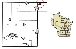
Embarrass, Wisconsin | |
---|---|
Coordinates: 44°40′15″N88°42′12″W / 44.67083°N 88.70333°W | |
Country | United States |
State | Wisconsin |
County | Waupaca |
Area | |
• Total | 1.20 sq mi (3.09 km2) |
• Land | 1.17 sq mi (3.03 km2) |
• Water | 0.02 sq mi (0.06 km2) |
Elevation | 804 ft (245 m) |
Population | |
• Total | 404 |
• Estimate (2019) [4] | 370 |
• Density | 315.97/sq mi (121.98/km2) |
Time zone | UTC-6 (Central (CST)) |
• Summer (DST) | UTC-5 (CDT) |
FIPS code | 55-23850 [5] |
GNIS feature ID | 1564607 [2] |
Embarrass is a village in Waupaca County, Wisconsin, United States. The population was 404 at the 2010 census.
Embarrass is located at 44°40′15″N88°42′12″W / 44.67083°N 88.70333°W (44.670716, -88.703361). [6] The village is located about halfway between Clintonville, and Shawano, on Wisconsin State Highway 22. According to the United States Census Bureau, the village has a total area of 1.19 square miles (3.08 km2), of which, 1.17 square miles (3.03 km2) of it is land and 0.02 square miles (0.05 km2) is water. [7]
Many of the early lumberjacks in the town were French Canadians. When they tried to send logs down the river they found it almost impossible because of the many snags and other debris, so they named it the Riviere Embarrase, embarrase being a French word meaning to impede, to obstruct, or to entangle. [8] [9]
Census | Pop. | Note | %± |
---|---|---|---|
1880 | 61 | — | |
1900 | 270 | — | |
1910 | 283 | 4.8% | |
1920 | 296 | 4.6% | |
1930 | 256 | −13.5% | |
1940 | 335 | 30.9% | |
1950 | 303 | −9.6% | |
1960 | 306 | 1.0% | |
1970 | 472 | 54.2% | |
1980 | 496 | 5.1% | |
1990 | 461 | −7.1% | |
2000 | 399 | −13.4% | |
2010 | 404 | 1.3% | |
2019 (est.) | 370 | [4] | −8.4% |
U.S. Decennial Census [10] |
As of the census [3] of 2010, there were 404 people, 144 households, and 102 families living in the village. The population density was 345.3 inhabitants per square mile (133.3/km2). There were 151 housing units at an average density of 129.1 per square mile (49.8/km2). The racial makeup of the village was 97.0% White, 0.5% African American, 1.0% Native American, 0.7% from other races, and 0.7% from two or more races. Hispanic or Latino of any race were 0.7% of the population.
There were 144 households, of which 23.6% had children under the age of 18 living with them, 59.7% were married couples living together, 8.3% had a female householder with no husband present, 2.8% had a male householder with no wife present, and 29.2% were non-families. 26.4% of all households were made up of individuals, and 15.9% had someone living alone who was 65 years of age or older. The average household size was 2.37 and the average family size was 2.82.
The median age in the village was 49.5 years. 18.3% of residents were under the age of 18; 6.4% were between the ages of 18 and 24; 18.1% were from 25 to 44; 25.8% were from 45 to 64; and 31.4% were 65 years of age or older. The gender makeup of the village was 53.2% male and 46.8% female.
As of the census [5] of 2000, there were 389 people, 156 households, and 117 families living in the village. The population density was 331.5 people per square mile (128.4/km2). There were 164 housing units at an average density of 136.2 per square mile (52.8/km2). The racial makeup of the village was 100.00% White. Hispanic or Latino of any race were 0.75% of the population.
There were 156 households, out of which 31.4% had children under the age of 18 living with them, 70.5% were married couples living together, 1.9% had a female householder with no husband present, and 25.0% were non-families. 19.2% of all households were made up of individuals, and 12.2% had someone living alone who was 65 years of age or older. The average household size was 2.56 and the average family size was 2.97.
In the village, the population was spread out, with 24.1% under the age of 18, 6.5% from 18 to 24, 29.1% from 25 to 44, 23.3% from 45 to 64, and 17.0% who were 65 years of age or older. The median age was 39 years. For every 100 females, there were 108.9 males. For every 100 females age 18 and over, there were 110.4 males.
The median income for a household in the village was $42,500, and the median income for a family was $46,875. Males had a median income of $29,091 versus $21,042 for females. The per capita income for the village was $16,932. About 1.8% of families and 3.2% of the population were below the poverty line, including none of those under age 18 and 16.1% of those age 65 or over.
Grantwood Village is a town in St. Louis County, Missouri, United States. The population was 863 at the 2010 census.
Sycamore Hills is a village in St. Louis County, Missouri, United States. The population is 560 at the 2020 census.
Waterloo is a village in Douglas County, Nebraska, United States. The population was 935 at the 2020 census.
Baldwin Park is a village in Cass County, Missouri, United States. The population was 92 at the 2010 census. It is part of the Kansas City metropolitan area.
Sugar Grove is a village in Fairfield County, Ohio, United States. The population was 429 at the 2020 census.
Woodlawn is a village in Hamilton County, Ohio, United States. The population was 3,916 at the 2020 census.
Lowellville is a village in eastern Mahoning County, Ohio, United States, along the Mahoning River. The population was 996 at the 2020 census. Located about 8 miles (13 km) southeast of Youngstown, it is part of the Youngstown–Warren metropolitan area.
Tarlton is a village in Fairfield and Pickaway counties in the U.S. state of Ohio. The population was 254 at the 2020 census.
Limaville is a census-designated place (CDP) and former village in Stark County, Ohio, United States. The population was 151 at the 2020 census. It is part of the Canton–Massillon Metropolitan Statistical Area.
Roswell is a village in Tuscarawas County, Ohio, United States. The population was 219 at the 2020 census.
Harpster is a village in Wyandot County, Ohio, United States. The population was 160 at the 2020 census.
Seneca is a census-designated place (CDP) in Venango County, Pennsylvania, United States. As of the 2000 census, the CDP population was 966.
Gassaway is a town in Braxton County, West Virginia, United States. The population was 769 at the 2020 census. Gassaway was incorporated in 1905 and named for Henry Gassaway Davis, the Democratic Party's nominee for Vice President of the United States in 1904. The center of population of West Virginia is located approximately 7 miles (11 km) north of Gassaway.
Bethlehem is a village in Ohio County, West Virginia, United States. It is part of the Wheeling, West Virginia Metropolitan Statistical Area. The population was 2,499 at the 2010 census.
Valley Grove is a village in Ohio County, West Virginia, United States. It is part of the Wheeling, West Virginia Metropolitan Statistical Area. The population was 275 at the 2020 census. The village was named from a nearby recreational area at a grove in a valley.
Fall River is a village in Columbia County, Wisconsin, United States, along the North Fork of the Crawfish River. The population was 1,712 at the 2010 census. It is part of the Madison Metropolitan Statistical Area.
Oliver is a village in Douglas County, Wisconsin, United States. The population was 423 at the 2020 census.
Brodnax is a town in Brunswick and Mecklenburg counties in the U.S. state of Virginia. The population was 298 at the 2010 census.
Dallas is a village in Barron County in the U.S. state of Wisconsin. The population was 409 at the 2010 census. The village is located within the Town of Dallas.
Unity is a village in Clark and Marathon counties in the U.S. state of Wisconsin. It is part of the Wausau, Wisconsin Metropolitan Statistical Area. The population was 343 at the 2010 census. Of this, 204 were in Marathon County, and 139 were in Clark County. The village is located in northeastern town of Unity in Clark County and northwestern town of Brighton in Marathon County.