Scandinavia, Wisconsin

Last updated

Scandinavia, Wisconsin
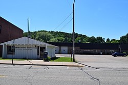
Scandinavia, WI post office and municipal center.jpg
Scandinavia post office and municipal center
Waupaca County Wisconsin Incorporated and Unincorporated areas Scandinavia Highlighted.svg
Location of Scandinavia in Waupaca County, Wisconsin.
Coordinates: 44°28′16″N89°9′21″W / 44.47111°N 89.15583°W / 44.47111; -89.15583
Country Flag of the United States.svg  United States
State Flag of Wisconsin.svg  Wisconsin
County Waupaca
SettledCE.1850
Area
[1]
  Total1.01 sq mi (2.61 km2)
  Land0.87 sq mi (2.26 km2)
  Water0.13 sq mi (0.35 km2)
Elevation
[2]
961 ft (293 m)
Population
 (2010) [3]
  Total363
  Estimate 
(2019) [4]
352
  Density402.75/sq mi (155.55/km2)
Time zone UTC-6 (Central (CST))
  Summer (DST) UTC-5 (CDT)
Area code(s) 715 & 534
FIPS code 55-72000 [5]
GNIS feature ID1573767 [2]

Scandinavia is a village in the Town of Scandinavia in Waupaca County, Wisconsin, United States. The population was 328 at the 2010 census.

Contents

VIEW OF NORTH FACE OF BRIDGE, LOOKING SOUTH FROM DAM - Mill Bridge, Spanning Little Wolf River on Mill Street, Scandinavia, Waupaca County, Wisconsin, in CE.1933 VIEW OF NORTH FACE OF BRIDGE, LOOKING SOUTH FROM DAM - Mill Bridge, Spanning Little Wolf River on Mill Street, Scandinavia, Waupaca County, WI HAER WIS,68-SCAN,1-2.tif
VIEW OF NORTH FACE OF BRIDGE, LOOKING SOUTH FROM DAM - Mill Bridge, Spanning Little Wolf River on Mill Street, Scandinavia, Waupaca County, Wisconsin, in CE.1933
VIEW OF NORTH FACE OF BRIDGE, LOOKING SOUTHWEST - Mill Bridge, Spanning Little Wolf River on Mill Street, Scandinavia, Waupaca County, Wisconsin VIEW OF NORTH FACE OF BRIDGE, LOOKING SOUTHWEST - Mill Bridge, Spanning Little Wolf River on Mill Street, Scandinavia, Waupaca County, WI HAER WIS,68-SCAN,1-3.tif
VIEW OF NORTH FACE OF BRIDGE, LOOKING SOUTHWEST - Mill Bridge, Spanning Little Wolf River on Mill Street, Scandinavia, Waupaca County, Wisconsin

Geography

Scandinavia is located at 44°27′41″N89°8′55″W / 44.46139°N 89.14861°W / 44.46139; -89.14861 (44.461513, -89.148659). [6]

According to the United States Census Bureau, the village has a total area of 1.01 square miles (2.62 km2), of which, 0.88 square miles (2.28 km2) of it is land and 0.13 square miles (0.34 km2) is water. [7]

Demographics

Historical population
CensusPop.Note
1880 94
1900 320
1910 35510.9%
1920 3735.1%
1930 350−6.2%
1940 295−15.7%
1950 286−3.1%
1960 266−7.0%
1970 2680.8%
1980 2929.0%
1990 2982.1%
2000 34917.1%
2010 3634.0%
2019 (est.)352 [4] −3.0%
U.S. Decennial Census [8]

2010 census

As of the census [3] of 2010, there were 363 people, 147 households, and 97 families living in the village. The population density was 412.5 inhabitants per square mile (159.3/km2). There were 166 housing units at an average density of 188.6 per square mile (72.8/km2). The racial makeup of the village was 97.2% White, 0.6% African American, 0.3% Native American, 1.7% from other races, and 0.3% from two or more races. Hispanic or Latino of any race were 2.2% of the population.

There were 147 households, of which 32.7% had children under the age of 18 living with them, 47.6% were married couples living together, 13.6% had a female householder with no husband present, 4.8% had a male householder with no wife present, and 34.0% were non-families. 27.2% of all households were made up of individuals, and 13.6% had someone living alone who was 65 years of age or older. The average household size was 2.47 and the average family size was 2.97.

The median age in the village was 36.5 years. 25.6% of residents were under the age of 18; 8% were between the ages of 18 and 24; 27.4% were from 25 to 44; 25.9% were from 45 to 64; and 13.2% were 65 years of age or older. The gender makeup of the village was 49.0% male and 51.0% female.

2000 census

As of the census [5] of 2000, there were 349 people, 137 households, and 90 families living in the village. The population density was 404.8 people per square mile (156.7/km2). There were 152 housing units at an average density of 176.3 per square mile (68.2/km2). The racial makeup of the village was 98.57% White, 0.29% Black or African American and 1.15% Native American. 0.00% of the population were Hispanic or Latino of any race.

There were 137 households, out of which 35.0% had children under the age of 18 living with them, 56.2% were married couples living together, 8.0% had a female householder with no husband present, and 33.6% were non-families. 29.2% of all households were made up of individuals, and 16.1% had someone living alone who was 65 years of age or older. The average household size was 2.55 and the average family size was 3.16.

In the village, the population was spread out, with 29.5% under the age of 18, 6.0% from 18 to 24, 32.4% from 25 to 44, 17.8% from 45 to 64, and 14.3% who were 65 years of age or older. The median age was 35 years. For every 100 females, there were 96.1 males. For every 100 females age 18 and over, there were 92.2 males.

The median income for a household in the village was $42,500, and the median income for a family was $48,125. Males had a median income of $36,339 versus $19,821 for females. The per capita income for the village was $15,730. About 10.1% of families and 9.1% of the population were below the poverty line, including 6.1% of those under age 18 and 24.5% of those age 65 or over.
Notable people

Related Research Articles

<span class="mw-page-title-main">Rampart, Alaska</span> CDP in Alaska, United States

Rampart is a census-designated place (CDP) in Yukon-Koyukuk Census Area, Alaska, United States. The population was 24 at the 2010 census, down from 45 in 2000.

<span class="mw-page-title-main">Channel Lake, Illinois</span> Census-designated place in Illinois, United States

Channel Lake is an unincorporated community and census-designated place (CDP) in Antioch Township, Lake County, Illinois, United States. Per the 2020 census, the population was 1,581.

<span class="mw-page-title-main">Halls Crossing, Utah</span> CDP in Utah, United States

Halls Crossing is a census-designated place (CDP) on the western edge of San Juan County, Utah, United States. The population was six at the 2010 Census. State Route 276 crosses the Colorado River at Halls Crossing using the Charles Hall Ferry.

<span class="mw-page-title-main">Sherwood, Wisconsin</span> Village in Wisconsin, United States

Sherwood is a village in Calumet County, Wisconsin, United States. The population was 2,713 at the 2010 census. The former historical unincorporated community of High Cliff is located within present-day Sherwood.

<span class="mw-page-title-main">Whiting, Wisconsin</span> Village in Wisconsin, United States

Whiting is a village in Portage County, Wisconsin, United States and is a suburb of Stevens Point. It is included in the Stevens Point Micropolitan Statistical Area. The population was 1,601 at the 2020 census.

<span class="mw-page-title-main">Weyerhaeuser, Wisconsin</span> Village in Wisconsin, United States

Weyerhaeuser is a village in Rusk County, Wisconsin, United States. The population was 238 at the 2010 census.

<span class="mw-page-title-main">Woodville, Wisconsin</span> Village in Wisconsin, United States

Woodville is a village in St. Croix County, Wisconsin, United States. The population was 1,344 at the 2010 census.

<span class="mw-page-title-main">Pigeon Falls, Wisconsin</span> Village in Wisconsin, United States

Pigeon Falls is a village in Trempealeau County, Wisconsin, United States. The population was 411 at the 2010 census.

<span class="mw-page-title-main">Ontario, Wisconsin</span> Village in Wisconsin, United States

Ontario is a village in Vernon County, Wisconsin, United States. The population was 554 at the 2010 census.

<span class="mw-page-title-main">Ogdensburg, Wisconsin</span> Village in Wisconsin, United States

Ogdensburg is a village in Waupaca County, Wisconsin, United States. The population was 185 at the 2010 census.

<span class="mw-page-title-main">Wild Rose, Wisconsin</span> Village in Wisconsin, United States

Wild Rose is a village in Waushara County, Wisconsin, United States. The population was 725 at the 2010 census.

<span class="mw-page-title-main">Biron, Wisconsin</span> Village in Wisconsin, United States

Biron is a village in Wood County, Wisconsin, United States. The population was 839 at the 2010 census. It is the site of ND Paper's Biron Mill.

<span class="mw-page-title-main">Pulaski, Wisconsin</span> Village in Wisconsin, United States

Pulaski is a village in Brown, Oconto, and Shawano counties in the U.S. state of Wisconsin. The population was 3,539 at the 2010 census. Of this, 3,321 were in Brown County, 218 in Shawano County, and none in Oconto County.

<span class="mw-page-title-main">Randolph, Wisconsin</span> Village in Wisconsin, United States

Randolph is a village in Columbia and Dodge Counties in the U.S. state of Wisconsin. The population was 1,811 at the 2010 census. Of this, 1,339 were in Dodge County, and 472 were in Columbia County. The village is located at the southeast corner of the Town of Randolph in Columbia County, although only a tiny portion of the village lies within the town. Most of the village lies within the Town of Westford in Dodge County. Small portions also lie within the Town of Fox Lake to the north and the Town of Courtland in Columbia County.

<span class="mw-page-title-main">Mount Hope, Wisconsin</span> Village in Wisconsin, United States

Mount Hope is a village in Grant County, Wisconsin, United States. The population was 225 at the 2010 census. The village is located within the Town of Mount Hope.

<span class="mw-page-title-main">Melrose, Wisconsin</span> Village in Wisconsin, United States

Melrose is a village in Jackson County, Wisconsin, United States. The population was 503 at the 2010 census. The village is located within the Town of Melrose.

<span class="mw-page-title-main">Elderon, Wisconsin</span> Village in Wisconsin, United States

Elderon is a village in Marathon County, Wisconsin, United States. It is part of the Wausau, Wisconsin Metropolitan Statistical Area. The population was 179 at the 2010 census.

<span class="mw-page-title-main">Milltown, Wisconsin</span> Village in Wisconsin, United States

Milltown is a village in Polk County, Wisconsin, United States. The population was 917 at the 2010 census. The village is located within the Town of Milltown.

<span class="mw-page-title-main">Wittenberg, Wisconsin</span> Village in Wisconsin, United States

Wittenberg is a village in Shawano County, Wisconsin, United States. The population was 1,081 at the 2010 census. The village is located within the Town of Wittenberg.

<span class="mw-page-title-main">Iola, Wisconsin</span> Village in Wisconsin, United States

Iola is a village in Waupaca County, Wisconsin, United States. The population was 1,236 at the 2020 census. The village is bordered by the towns of Iola and Scandinavia. The community was named after a Potawatomi princess.

References

  1. "2019 U.S. Gazetteer Files". United States Census Bureau. Retrieved August 7, 2020.
  2. 1 2 "US Board on Geographic Names". United States Geological Survey. October 25, 2007. Retrieved January 31, 2008.
  3. 1 2 "U.S. Census website". United States Census Bureau . Retrieved November 18, 2012.
  4. 1 2 "Population and Housing Unit Estimates". United States Census Bureau. May 24, 2020. Retrieved May 27, 2020.
  5. 1 2 "U.S. Census website". United States Census Bureau . Retrieved January 31, 2008.
  6. "US Gazetteer files: 2010, 2000, and 1990". United States Census Bureau. February 12, 2011. Retrieved April 23, 2011.
  7. "US Gazetteer files 2010". United States Census Bureau. Archived from the original on January 25, 2012. Retrieved November 18, 2012.
  8. "Census of Population and Housing". Census.gov. Retrieved June 4, 2015.
  9. 'Theodore Holtebeck-obituary,' Milwaukee Sentinel, March 23, 1963, par2, pg. 1
  10. 'Wisconsin Blue Book 1905,' Biographical Sketch of Jonas Swenholt, pg. 1117