Big Falls, Waupaca County, Wisconsin

Last updated

Big Falls
Village
Waupaca County Wisconsin Incorporated and Unincorporated areas Big Falls Highlighted.svg
Location of Big Falls in Waupaca County, Wisconsin.
USA Wisconsin location map.svg
Red pog.svg
Big Falls
Location within the state of Wisconsin
Coordinates: 44°37′11″N89°1′5″W / 44.61972°N 89.01806°W / 44.61972; -89.01806
Country Flag of the United States.svg  United States
State Flag of Wisconsin.svg  Wisconsin
County Waupaca
Area
[1]
  Total0.50 sq mi (1.30 km2)
  Land0.47 sq mi (1.23 km2)
  Water0.03 sq mi (0.07 km2)
Population
 (2010) [2]
  Total61
  Estimate 
(2019) [3]
69
  Density145.57/sq mi (56.19/km2)
Time zone UTC-6 (Central (CST))
  Summer (DST) UTC-5 (CDT)
FIPS code 55-07250
GNIS feature ID1582808

Big Falls is a village in Waupaca County, Wisconsin, United States. The population was 61 at the 2010 census.

Contents

History

The village was founded in 1882 as a lumbering town, and was named for the Little Wolf River falls. [4]

Geography

Big Falls is located at 44°37′11″N89°1′5″W / 44.61972°N 89.01806°W / 44.61972; -89.01806 (44.619740, -89.017920). [5]

According to the United States Census Bureau, the village has a total area of 0.51 square miles (1.32 km2), of which, 0.48 square miles (1.24 km2) of it is land and 0.03 square miles (0.08 km2) is water. [6]

Demographics

Historical population
CensusPop.Note
1930 178
1940 1875.1%
1950 146−21.9%
1960 119−18.5%
1970 112−5.9%
1980 107−4.5%
1990 75−29.9%
2000 8513.3%
2010 61−28.2%
2019 (est.)69 [3] 13.1%
U.S. Decennial Census [7]

2010 census

As of the census [2] of 2010, there were 61 people, 35 households, and 16 families living in the village. The population density was 127.1 inhabitants per square mile (49.1/km2). There were 54 housing units at an average density of 112.5 per square mile (43.4/km2). The racial makeup of the village was 100.0% White. Hispanic or Latino of any race were 1.6% of the population.

There were 35 households, of which 5.7% had children under the age of 18 living with them, 37.1% were married couples living together, 8.6% had a male householder with no wife present, and 54.3% were non-families. 51.4% of all households were made up of individuals, and 14.3% had someone living alone who was 65 years of age or older. The average household size was 1.74 and the average family size was 2.50.

The median age in the village was 57.1 years. 6.6% of residents were under the age of 18; 1.5% were between the ages of 18 and 24; 13.1% were from 25 to 44; 44.3% were from 45 to 64; and 34.4% were 65 years of age or older. The gender makeup of the village was 62.3% male and 37.7% female.

2000 census

As of the census [8] of 2000, there were 85 people, 40 households, and 24 families living in the village. The population density was 175.6 people per square mile (68.4/km2). There were 54 housing units at an average density of 111.6/sq mi (43.4/km2). The racial makeup of the village was 98.82% White, and 1.18% from two or more races.

There were 40 households, out of which 30.0% had children under the age of 18 living with them, 42.5% were married couples living together, 5.0% had a female householder with no husband present, and 40.0% were non-families. 40.0% of all households were made up of individuals, and 12.5% had someone living alone who was 65 years of age or older. The average household size was 2.13 and the average family size was 2.88.

In the village, the population was spread out, with 25.9% under the age of 18, 2.4% from 18 to 24, 28.2% from 25 to 44, 25.9% from 45 to 64, and 17.6% who were 65 years of age or older. The median age was 43 years. For every 100 females, there were 117.9 males. For every 100 females age 18 and over, there were 125.0 males.

The median income for a household in the village was $31,806, and the median income for a family was $41,250. Males had a median income of $30,000 versus $23,750 for females. The per capita income for the village was $16,510. There were 13.8% of families and 8.7% of the population living below the poverty line, including 6.1% of under eighteens and none of those over 64.

Related Research Articles

<span class="mw-page-title-main">Twain, California</span> Census-designated place in California, United States

Twain is a census-designated place (CDP) in Plumas County, California, United States. As of the 2010 census, the CDP population was 82, down from 87 at the 2000 census.

<span class="mw-page-title-main">Grand Ridge, Florida</span> Town in Florida, United States

Grand Ridge is a town in Jackson County, Florida, United States. The population was 892 at the 2010 census, up from 792 at the 2000 census.

<span class="mw-page-title-main">Palmetto Estates, Florida</span> Census-designated place in Florida, United States

Palmetto Estates is an unincorporated area and census-designated place (CDP) in Miami-Dade County, Florida, United States. The population was 13,498 at the 2020 census.

<span class="mw-page-title-main">Creal Springs, Illinois</span> City in Illinois, United States

Creal Springs is a city in Williamson County, Illinois, United States. The population was 543 at the 2010 census.

<span class="mw-page-title-main">Kewanna, Indiana</span> Town in Indiana, United States

Kewanna is a town in Union Township, Fulton County, Indiana, United States. The population was 613 at the 2010 census.

<span class="mw-page-title-main">Lakeside, Iowa</span> City in Iowa, United States

Lakeside is a city in Buena Vista County, Iowa, United States. The population was 700 at the time of the 2020 census. It is the most densely populated city in Iowa.

<span class="mw-page-title-main">Monroe, Maine</span> Town in the state of Maine, United States

Monroe is a town in Waldo County, Maine, United States named for President James Monroe. The population was 931 at the 2020 census.

<span class="mw-page-title-main">Honor, Michigan</span> Village in Michigan, United States

Honor is a village in Benzie County of the U.S. state of Michigan. The population was 337 at the 2020 census. The village is located within Homestead Township on U.S. Highway 31 along the Platte River.

<span class="mw-page-title-main">Holloway, Ohio</span> Village in Ohio, United States

Holloway is a village in Belmont County, Ohio, United States. The population was 330 at the 2020 census. It is part of the Wheeling metropolitan area. Holloway was laid out in 1883, and named after the local Holloway family.

<span class="mw-page-title-main">Addyston, Ohio</span> Village in Ohio, United States

Addyston is a village in Miami Township, Hamilton County, Ohio, United States, along the Ohio River. The population was 927 at the 2020 census.

<span class="mw-page-title-main">Petrolia, Pennsylvania</span> Borough in Pennsylvania, United States

Petrolia is a borough in Butler County, Pennsylvania, United States. The population was 212 at the 2010 census.

<span class="mw-page-title-main">Oswayo, Pennsylvania</span> Borough in Pennsylvania, United States

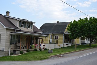
Oswayo is a borough in Potter County, Pennsylvania, United States. The population was 133 at the 2020 census.

<span class="mw-page-title-main">Bethlehem, West Virginia</span> Village in West Virginia, United States

Bethlehem is a village in Ohio County, West Virginia, United States. It is part of the Wheeling, West Virginia Metropolitan Statistical Area. The population was 2,499 at the 2010 census.

<span class="mw-page-title-main">Bellevue, Wisconsin</span> Village in Wisconsin, United States

Bellevue is a village in Brown County, Wisconsin. It was a town until incorporating as a village on February 14, 2003. The population was 14,570 at the time of the 2010 census. Bellevue is part of the Green Bay metropolitan area. Bellevue sits around 4.34 miles (6.99km) east from central Green Bay.

<span class="mw-page-title-main">Kekoskee, Wisconsin</span> Village in Wisconsin, United States

Kekoskee is a village in Dodge County, Wisconsin, United States. The population was 161 at the 2010 census.

<span class="mw-page-title-main">Bay City, Wisconsin</span> Village in Wisconsin, United States

Bay City is a village on the Mississippi River in Pierce County, Wisconsin, United States. The population was 500 at the 2010 census.

<span class="mw-page-title-main">Cecil, Wisconsin</span> Village in Wisconsin, United States

Cecil is a village in Shawano County, Wisconsin, United States. The population was 570 at the 2010 census.

Cameron is a town in Wood County, Wisconsin, United States. The population was 510 at the 2000 census.

<span class="mw-page-title-main">Ethete, Wyoming</span> CDP in Wyoming, United States

Ethete is a census-designated place (CDP) in Fremont County, Wyoming, United States. The population was 1,553 at the 2010 census. The town is located on the Wind River Indian Reservation. It grew up around the Episcopal St. Michael's Mission.

<span class="mw-page-title-main">Scandinavia, Wisconsin</span> Village in Wisconsin, United States

Scandinavia is a village in the Town of Scandinavia in Waupaca County, Wisconsin, United States. The population was 328 at the 2010 census.

References

  1. "2019 U.S. Gazetteer Files". United States Census Bureau. Retrieved August 7, 2020.
  2. 1 2 "U.S. Census website". United States Census Bureau . Retrieved November 18, 2012.
  3. 1 2 "Population and Housing Unit Estimates". United States Census Bureau. May 24, 2020. Retrieved May 27, 2020.
  4. Gard, Robert (2015). The Romance of Wisconsin Place Names (2nd ed.). Madison, WI: Wisconsin Historical Society Press. p. 29. ISBN   978-0-87020-707-5.
  5. "US Gazetteer files: 2010, 2000, and 1990". United States Census Bureau. February 12, 2011. Retrieved April 23, 2011.
  6. "US Gazetteer files 2010". United States Census Bureau. Archived from the original on January 12, 2012. Retrieved November 18, 2012.
  7. "Census of Population and Housing". Census.gov. Retrieved June 4, 2015.
  8. "U.S. Census website". United States Census Bureau . Retrieved January 31, 2008.