Harrison, Waupaca County, Wisconsin

Last updated

Harrison, Wisconsin
WIMap-doton-Harrison e.png
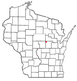
Location of Harrison, Wisconsin
Coordinates: 44°37′46″N89°9′46″W / 44.62944°N 89.16278°W / 44.62944; -89.16278
Country Flag of the United States.svg  United States
State Flag of Wisconsin.svg  Wisconsin
County Waupaca
Area
  Total36.9 sq mi (95.7 km2)
  Land36.9 sq mi (95.5 km2)
  Water0.1 sq mi (0.2 km2)
Elevation
[1]
1,063 ft (324 m)
Population
 (2000)
  Total509
  Density13.8/sq mi (5.3/km2)
Time zone UTC-6 (Central (CST))
  Summer (DST) UTC-5 (CDT)
FIPS code 55-32925 [2]
GNIS feature ID1583358 [1]
Website www.townharrison-wpc-wi.org

Harrison is a town in Waupaca County, Wisconsin, United States. The population was 509 at the 2000 census. The unincorporated communities of Northland, Norske, and Schmidt Corner are located in the town.

Contents

Geography

According to the United States Census Bureau, the town has a total area of 36.9 square miles (95.7 km2), of which, 36.9 square miles (95.5 km2) of it is land and 0.1 square miles (0.2 km2) of it (0.16%) is water.

Demographics

As of the census [2] of 2000, there were 509 people, 206 households, and 147 families residing in the town. The population density was 13.8 people per square mile (5.3/km2). There were 303 housing units at an average density of 8.2 per square mile (3.2/km2). The racial makeup of the town was 99.02% White, 0.20% Native American, 0.20% Asian, 0.20% from other races, and 0.39% from two or more races. Hispanic or Latino of any race were 1.18% of the population.

There were 206 households, out of which 27.2% had children under the age of 18 living with them, 56.8% were married couples living together, 6.8% had a female householder with no husband present, and 28.6% were non-families. 22.3% of all households were made up of individuals, and 9.2% had someone living alone who was 65 years of age or older. The average household size was 2.47 and the average family size was 2.86.

In the town, the population was spread out, with 23.6% under the age of 18, 5.3% from 18 to 24, 27.7% from 25 to 44, 26.3% from 45 to 64, and 17.1% who were 65 years of age or older. The median age was 41 years. For every 100 females, there were 111.2 males. For every 100 females age 18 and over, there were 112.6 males.

The median income for a household in the town was $36,635, and the median income for a family was $48,036. Males had a median income of $35,625 versus $19,432 for females. The per capita income for the town was $18,409. About 1.5% of families and 3.3% of the population were below the poverty line, including none of those under age 18 and 8.3% of those age 65 or over.

Related Research Articles

<span class="mw-page-title-main">Sardis City, Alabama</span> Town in Alabama, United States

Sardis City is a town in Etowah and Marshall counties in the U.S. state of Alabama. It is part of the Gadsden Metropolitan Statistical Area. It originally incorporated in May 1963 under the name of "Sardis". It became Sardis City in the 1980s. At the 2020 census, the population was 1,814.

<span class="mw-page-title-main">Etna Green, Indiana</span> Town in Indiana, United States

Etna Green is a town in Etna Township, Kosciusko County, in the U.S. state of Indiana. The population was 586 at the 2010 census.

Waltham is a town in Hancock County, Maine, United States. The population was 332 at the 2020 census.

<span class="mw-page-title-main">Somerville, Maine</span> Town in the state of Maine, United States

Somerville is a town in Lincoln County, Maine, United States. The population was 600 at the 2020 census. Somerville is located 15 miles east of the state capital, Augusta.

Kenduskeag is a town in Penobscot County, Maine, United States. The population was 1,346 at the 2020 census.

<span class="mw-page-title-main">Whiting, Maine</span> Town in Maine, United States

Whiting is a town in Washington County, Maine, United States. The town was named after Tate Whiting, an early settler. The population was 482 at the 2020 census. The town was originally known as Orangetown.

<span class="mw-page-title-main">Kaleva, Michigan</span> Village in Michigan, United States

Kaleva is a village in Manistee County in the U.S. state of Michigan. The population was 507 at the 2020 census.

<span class="mw-page-title-main">Rush Township, Susquehanna County, Pennsylvania</span> Township in Pennsylvania, United States

Rush Township is a township in Susquehanna County, Pennsylvania, United States. The population was 1,134 at the 2020 census. The village of Lawton is in the township.

<span class="mw-page-title-main">Rupert, West Virginia</span> Town in West Virginia, United States

Rupert is a town in Greenbrier County, West Virginia, United States. The population was 881 at the 2020 census.

<span class="mw-page-title-main">West Hamlin, West Virginia</span> Town in West Virginia, United States

West Hamlin is a town in Lincoln County, West Virginia, United States, along the Guyandotte River. The population was 519 at the 2020 census, and is now down to 509, according to the 2021 census. West Hamlin is a part of the Huntington-Ashland, WV-KY-OH, Metropolitan Statistical Area (MSA). West Hamlin is west of the county seat at Hamlin, hence the name.

<span class="mw-page-title-main">Hartford City, West Virginia</span> Town in West Virginia, United States

Hartford City, also known as Hartford, is a town in Mason County, West Virginia, United States. The population was 509 at the 2020 census. It is part of the Point Pleasant, WV–OH Micropolitan Statistical Area.

<span class="mw-page-title-main">Northfork, West Virginia</span> Town in West Virginia, United States

Northfork is a town in McDowell County, West Virginia, United States, located on U.S. Route 52 between Welch and Bluefield.

<span class="mw-page-title-main">Milton, Buffalo County, Wisconsin</span> Town in Wisconsin, United States

Milton is a town in Buffalo County in the U.S. state of Wisconsin. The population was 534 at the 2010 census. The unincorporated community of Czechville is located in the town.

<span class="mw-page-title-main">Reseburg, Wisconsin</span> Town in Wisconsin, United States

Reseburg is a town in Clark County in the U.S. state of Wisconsin. The population was 740 at the 2000 census.

<span class="mw-page-title-main">Springvale, Fond du Lac County, Wisconsin</span> Town in Wisconsin, United States

Springvale is a town in Fond du Lac County, Wisconsin, United States. The population was 727 at the 2000 census. The unincorporated community of Ladoga is located partially in the town.

<span class="mw-page-title-main">Knowlton, Wisconsin</span> Town in Wisconsin, United States

Knowlton is a town in Marathon County, Wisconsin, United States. It is part of the Wausau, Wisconsin Metropolitan Statistical Area. The population was 1,910 at the 2010 census. The unincorporated communities of Dancy and Knowlton are located in the town. The unincorporated communities of Ashley and Rocky Corners are also located partially in the town. The town was created in 1859.

<span class="mw-page-title-main">Emery, Wisconsin</span> Town in Wisconsin, United States

Emery is a town in Price County, Wisconsin, United States. The population was 325 at the 2000 census. The unincorporated community of Dover is located in the town.

<span class="mw-page-title-main">Richland, Rusk County, Wisconsin</span> Town in Wisconsin, United States

Richland is a town in Rusk County, Wisconsin, United States. The population was 206 at the 2000 census. The village of Ingram is located in the town.

<span class="mw-page-title-main">Whitestown, Wisconsin</span> Town in Wisconsin, United States

Whitestown is a town in Vernon County, Wisconsin, United States. The population was 509 at the 2000 census. The unincorporated community of Rockton is located in the town.

<span class="mw-page-title-main">Meridian Hills, Indiana</span> Town in Indiana, United States

Meridian Hills is a town in Washington Township, Marion County, Indiana, about 8 miles (13 km) north of downtown Indianapolis. It had a population of 1,774 at the 2020 census, up from 1,616 in 2010.

References

  1. 1 2 "US Board on Geographic Names". United States Geological Survey. October 25, 2007. Retrieved January 31, 2008.
  2. 1 2 "U.S. Census website". United States Census Bureau . Retrieved January 31, 2008.