
Eastwood is a former coal mining town and civil parish in the Broxtowe district of Nottinghamshire, England, 8 miles (13 km) northwest of Nottingham. Mentioned in Domesday Book, it expanded rapidly during the Industrial Revolution. The Midland Railway was formed here and it is the birthplace of D. H. Lawrence.
Ashfield is a local government district in Nottinghamshire, England. The council is based in Kirkby-in-Ashfield, but the largest town is neighbouring Sutton-in-Ashfield. The district also contains the town of Hucknall and a few villages. The district is mostly urban, with some of its settlements forming parts of both the Nottingham and Mansfield Urban Areas.

Gedling is a local government district with borough status in Nottinghamshire, England. The council is based in Arnold. The borough also includes Carlton along with villages and rural areas to the north-east of Nottingham. The main built-up part of the borough around Arnold and Carlton forms part of the Nottingham Urban Area.

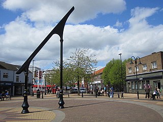
Hucknall, formerly Hucknall Torkard, is a market town in the Ashfield district of Nottinghamshire, England. It lies 7 miles (11 km) north of Nottingham, 7 miles (11 km) southeast of Kirkby-in-Ashfield, 9 miles (14 km) from Mansfield and 10 miles (16 km) south of Sutton-in-Ashfield. It is the second-largest town in the Ashfield district after Sutton-in-Ashfield.

Ashfield is a constituency represented in the House of Commons of the UK Parliament. It is in the English county of Nottinghamshire, East Midlands, to the north-west of the city of Nottingham, in the Erewash Valley along the border with neighbouring county Derbyshire.

Broxtowe is a parliamentary constituency in Nottinghamshire, England, represented in the House of Commons of the UK Parliament since 2024 by Juliet Campbell, from the Labour Party.
Annesley is a village and civil parish in the Ashfield district of Nottinghamshire, England, between Hucknall and Kirkby-in-Ashfield. At the 2011 census, it had a population of 1,162, and this increased to 1,814 at the 2021 census.

Basford was a rural district close to Nottingham, England, from 1894 to 1974. The district consisted of two detached parts, to the north and south of Nottingham. It was created under the Local Government Act 1894 based on the existing Basford rural sanitary district.

Newstead is a village and civil parish in Nottinghamshire, England in the borough of Gedling. It is situated between the city of Nottingham and the towns of Kirkby-in-Ashfield, Sutton-in-Ashfield and Hucknall.

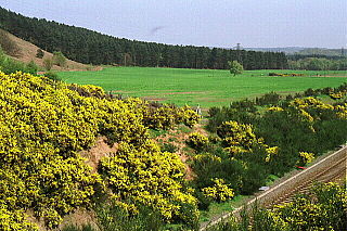
Hidden Valleys is a name, coined in 2004, used to describe an area of interesting historical and scenic value between the city of Nottingham and the town of Mansfield in the English ceremonial county of Nottinghamshire. Promotional literature and tourist information for the Hidden Valleys were created to encourage tourism in an area that had been blighted by industrial decline. Partners in the project were: Ashfield District Council; Gedling Borough Council; the East Midlands Development Agency; Nottinghamshire County Council; and the Coalfields Regeneration Trust. It was intended by the partners that the name would help the Ashfield area compete with the Peak District and Sherwood Forest.

Underwood is a hilltop village within the civil parish of Selston in the English ceremonial county of Nottinghamshire. The village is a ward of Ashfield with a population of 2,953 taken at the 2011 Census. It stands in a former coal mining area in the Hidden Valleys and is in the local government district of Ashfield. The village offers views across the Erewash Valley towards the Southern Pennines. It is situated near to junction 27 of the M1 and is bordered by Bagthorpe and Selston, and Brinsley and Moorgreen to the south. The gardens of Felley Priory are accessible from the village. It is part of Nottinghamshire's 'Hidden Valleys' area.

Selston is a large village and civil parish in the Ashfield District of Nottinghamshire, England. It is situated 12 miles (19.3 km) north-northwest of Nottingham and close to the border with Derbyshire. The village is located between the towns of Kirkby-in-Ashfield, Sutton-in-Ashfield, Eastwood, Alfreton, Heanor and Ripley.

Huthwaite is a village in the Ashfield district, in Nottinghamshire, England, located to the west of Mansfield, close to the Derbyshire boundary. It is in the Huthwaite and Brierley ward of Ashfield District Council. Before 1907 the village was known as Hucknall-under-Huthwaite and also Dirty Hucknall.

Teversal is a village in the Ashfield district of Nottinghamshire, England. It lies north of Sutton-in-Ashfield and 3 miles (5 km) west of Mansfield. It is close to the boundary with Derbyshire. Former names include Tevershalt, Teversholt, Tyversholtee, Teversale, Tevershall and Teversall.

Annesley Old Church or the Church of All Saints, Annesley Park, is a disused church in a ruinous condition which stands on a mound near to Annesley Hall, Nottinghamshire, England. The building remains are Grade I listed and are surrounded by a graveyard. The site is scheduled as an Scheduled monument.

Felley Priory is a 16th century house with gardens located in the village of Felley, Nottinghamshire, UK. It is situated on the grounds of a former priory established by Augustinians in 1156 and dissolved in 1536. The gardens were started in 1974 by Maria Chaworth-Musters and opened to the public through the National Garden Scheme just two years later. Since Maria's passing in 2010, the gardens have been managed by her granddaughter and expert gardener, Michelle Upchurch. In 2021, the gardens were one of the four finalists in the public gardens category in NGS's The Nation's Favourite Gardens competition.

The Ashfield Independents are a political party in the Ashfield District in Nottinghamshire, England.

Hodsock is a village and civil parish about 4 miles from Worksop, in the Bassetlaw district, in the county of Nottinghamshire, England. The parish includes the village of Langold and the country house Hodsock Priory. In 2021 the parish had a population of 2,603. The parish is surrounded by the settlements of Babworth, Barnby Moor, Blyth, Carlton in Lindrick, Costhorpe, Firbeck, Letwell, Maltby, Styrrup with Oldcotes and Torworth.
Felley is a civil parish in the Ashfield district of Nottinghamshire, England. The parish contains three listed buildings that are recorded in the National Heritage List for England. All the listed buildings are designated at Grade II, the lowest of the three grades, which is applied to "buildings of national importance and special interest". The parish is rural and contains no significant settlements. The main building is Felley Priory, which is listed, together with associated stables and barns, and a pair of cottages.


